I know during the show today, I mentioned a chance for 1” to 4” of snow across the high plains next Tuesday.
So how did I come to that conclusion? How does it breakdown? Let’s take a look!
In order for the panhandles to get a good shot at significant snowfall, we need a few things to happen.
And the 0z GFS is suggeting we will get a few of the necessary ingredients on Tuesday of next week.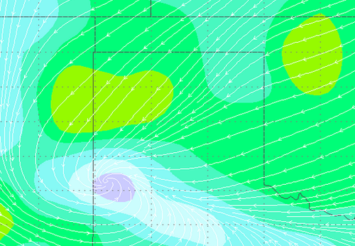 The first is an “upslope flow” with winds from the northeast and east. That does two things, it ushers in colder air and as the air moves up onto the caprock is rises, cools and condenses. That helps squeeze moisture out of the air, raising our humidity levels… but i’ll touch more on that in a second.
The graphic above and the one below indicated the wind directions and speeds (blue = 10-20mph / green 15-25mph). The top graphic is from Tuesday morning and the one below is from Tuesday evening.
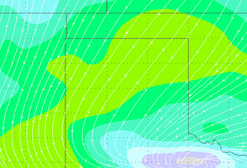 Notice that the winds will increase during the day and shift from the east-northeast and eventually from the northeast Tuesday morning into the afternoon. The east wind will give us the greatest influx of moisture.
So, we increase our available moisture big deal, right? Well, it’s a bigger deal that you think. As our humidity goes up so does the chance that a raindrop or snowflake make it all the way to the ground before evaporating.
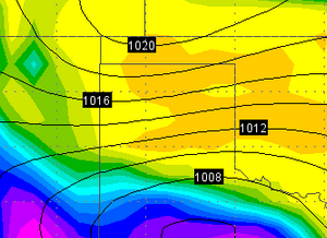 And the humidity levels graphic to the right (green=70% / orange=90%) shows most of the high plains with humidity levels at or above 80 percent. That will help us get all of that moisture from the clouds above, to the ground below.
But that’s not all, with all of the moisture at the surface, let’s take a look aloft to see if it will have a chance to go anywhere.
The graphic below shows isobars (the lines which measure of smilar pressure) and wind direction at about 30,000ft.
Where we see the isobars are diverging, or spreading out, it shows that there is a void in the atmosphere which means the air below – if buoyant enough – can rise into that space.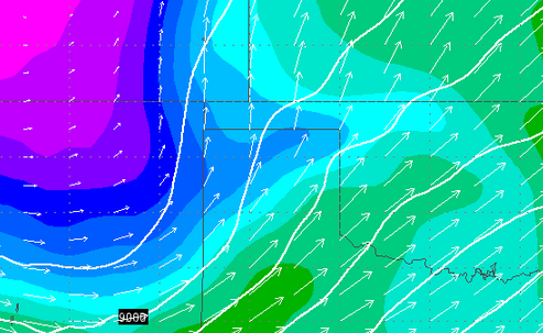 And rising air, recall from above, cools and condenses. But in this case, instead of rising from 1,500ft to 3,600ft, its rising from 3,600ft to 30,000ft… and now has a chance to eventually precipitate! And if it precipitates back into air with a humidity level high enough, it won’t evaporate as virga on the way down! Meaning it will reach the surface!
So the question is, based on all of this information, what are some of the models projecting for precipitation totals? Well, the graphic below is the snowfall totals for the 0z rendering of the GFS.

The totals (green=1” / orange=12”) range from 1” to 12” of snow across the high plains. This model runs suggesting 4” to 6” in Amarillo.
Now with that being said, you can’t always trust just ONE weather model. And this model run, the GFS, is rendered (offering meteorologists new numbers) every 6 hours. So this total isn’t the end-all-be-all, but it is a possibility.
Right now, based on other weather models, my “gut” feeling and historical data, I am leaning more toward a 1” to 4” snow event for the high plains.
Like always though, I’ll be watching it as we close out the week, head into the weekend and start our next work week!


