Hail, high winds, tornadoes… And snow? The high plains, central plains and south plains are all bracing for another round of severe weather followed by another bout with Jack Frost.
It’s like the uncle that won’t leave the Christmas party – winter is holding on, refusing to move.
As an upper low pinwheels it’s way through the Great Basin and out onto the high plains the atmospheric set up is ripe for another chance for severe thunderstorms capable of producing damaging downburst winds, large hail, flooding rains and tornadoes.
I know what you’re thinking. You’re saying, “Hold on a second, Nick!”
You’re right. Nearly one week ago when a similar scenario was projected and it was almost a complete severe weather dud.
And you’re – sort of – correct.
Yes, we will be dealing with a cap of warm air aloft. Yes, some models suggest that the cold front will meander around, therefore lack the necessary forcing for severe storms.
And yes, across part of the area slated for severe weather it might be too cloudy.
But hold on! It is April and you shouldn’t let your guard down.
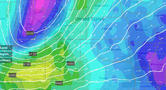
The latest models are projecting CAPE values between 1,000 J/kg and 3,000 J/kg on Wednesday. That will be coupled with Bulk Shear values above 40 knots. The combination of the two along with Helicity levels suggested by models to be above 500 m2/s-2, is painting a picture for a severe weather outbreak.
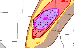
The Storm Prediction Center is on-board with the severe weather threat as well. They have already issued a “Moderate” risk for severe weather across parts of Oklahoma tomorrow. The Weather Channel has issued a TOR:CON of 6 at last check, too.
 Not sure what they “named” this storm, though.
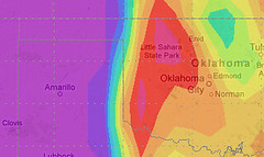
So where exactly is the biggest threat? Right now it looks like Central Oklahoma.
On Wednesday afternoon, at 300mb, the atmosphere will be diverging over parts of central and western Oklahoma. This is one of the first things to look for with any kind of precipitation. We need to make sure the atmosphere can support some kind of ascent.
Over the same area, at 300mb, the winds will be from the southwest at – roughly – 35- to 70-knots. Meanwhile at the surface, wind will be from the southeast at 12- to 24-knots.
The winds from the southeast at the surface will help pump in the Gulf moisture necessary in the afternoon. Dewpoints are projected to be in the upper 50s to low 70s.
Also, the CAPE values, Bulk Shear and Helicity – as stated above – will all be more than ample to produce severe weather. So the table is set, it will just be a matter of cold front speed.


