There is currently a lot of misinformation (and fear) floating around the internet about the development of a hurricane in the Atlantic Ocean threatening the Gulf Coast of the United States late next week. While there is a cluster of storms east of the Greater and Lesser Antilles, there isn’t any clear sign that the cluster of storms will develop into anything – much less a major hurricane.
From the National Hurricane Center (as of 8/19/14, 11:00pm):
1. Disorganized shower and thunderstorm activity continues in association with an elongated area of low pressure that extends from the northeastern coast of South America into the central tropical Atlantic. Environmental conditions are forecast to be more conducive for gradual development of this system during the next few days as it approaches the Lesser Antilles and moves into the Caribbean Sea.
* Formation chance through 48 hours…medium…30 percent.
* Formation chance through 5 days…medium…50 percent.
In short, the National Hurricane Center is only giving it a 50 percent chance of developing into a tropical depression, much less a hurricane, during the next five days. If you are reading or hearing otherwise from other people – keep your skeptical antennae up.
But to keep people informed and aware of potential hazardous weather, a lot of meteorologists try to forecast beyond that five day window. And it isn’t easy. There are a lot of things that can and will inhibit or increase the rate of development in the coming days.
Some factors that meteorologists are watching:
- Sea surface temperature
- Low level rotation
- Upper level high pressure
- Wind shear
- Steering winds
Some factors that meteorologists are not watching but that some people insist are worthy of watching:
- The number of bugs in the air this year compared to before Hurricane Katrina hit New Orleans
- The number of dry days in a row this year compared to before Hurricane Camille hit Mississippi
- How long between the need to mow the yard this year compared to when Hurricane Andrew hit Florida
The truth is, at this distance in time, there is very little that anyone can accurately predict about this cluster of storms. Because it also has a 50 percent chance of not developing at all. But meteorologists can show maps, post computer weather models and discuss the possibilities. But possibilities aren’t predictions. And computer weather model maps are not forecasts.
Plus, at this distance in time, there is a lot of inconsistency – even within the same models! Here is a perfect example of model inconsistency. The following four pictures are four consecutive model outputs from the GFS computer weather model for roughly the same time period – between 1am and 7am Thursday August 28th. These pictures are in order from most recent to least recent.
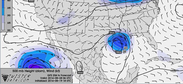


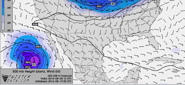
Notice that in just 18 hours the track and strength suggested by this one model vary drastically. In one the wind speed at 500mb (18,000 feet) is above 50kts (about 60mph) and in another, the storm doesn’t even exist. And again, that is just 18 hours. The latest rendering of the GFS, the 0z for 8/20/14 keep it in the Gulf of Mexico during the same time frame as above, just north of the Yucatan with a 500mb wind of roughly 20kts.
I get it, though.
I know you want an accurate weather forecast a week – or even two weeks! – in advance of your wedding, your birthday party or just because you want to know. But right now, the science and math are only so good. Every day the computer models get better and every day meteorologists learn more, but there is a limit to what we can predict accurately due to the complexity of the atmosphere. That limit right now is about five days. We’re “okay” to eight.
If anyone else tells you otherwise, they’re wrong. Including those predicting a major hurricane will hit the Gulf Coast. Ten days from now.
(UPDATE: 12:00 PM 8/21/14)
The National Hurricane Center has upgraded the cluster of storms to “likely” development:
Data from an Air Force Reserve Hurricane Hunter aircraft indicate that the circulation associated with the small low pressure area approaching the Leeward Islands is poorly defined. In addition, the associated shower activity has decreased during the past few hours. The aircraft did, however, find a small area of tropical-storm-force winds on the northeast side of the low. Environmental conditions are expected to be conducive for some development during the next day or so, and a tropical depression or tropical storm could still form while the system moves west-northwestward at around 20 mph across the Lesser Antilles. The mountainous terrain of Hispaniola could limit development during the first part of the weekend, but conditions are expected to become more conducive for development by Sunday when the system is forecast to move near or over the Bahamas. Regardless of tropical cyclone formation, gusty winds and heavy rainfall are expected across portions of the Lesser Antilles, Puerto Rico, and the Virgin Islands through Friday, and over Hispaniola late Friday and Saturday. Interests in those islands and in the Bahamas should closely monitor the progress of this disturbance. An Air Force Reserve Hurricane Hunter aircraft is scheduled to investigate this system again tomorrow afternoon.
* Formation chance through 48 hours…medium…50 percent.
* Formation chance through 5 days…high…70 percent.
Most of the forecast models now keep the storm farther east and out to sea. Because we are a few days closer, we are also entering the time period where we can get a better feel for strength. And most forecast models keep this storm at “Tropical Storm” strength. Again, that doesn’t mean we are out of the woods, but just goes to show that you can’t always trust computer weather models more than five days out.


