It doesn’t appear that Invest 96L is in any hurry to get to where it wants to go. The tropical wave is still a tropical wave and is still slowly moving toward the Bahamas. Latest model data suggests that shear may inhibit development during the next 6 – 18 hours, but that eventually that atmosphere will be conducive to strengthening.
From the National Hurricane Center:
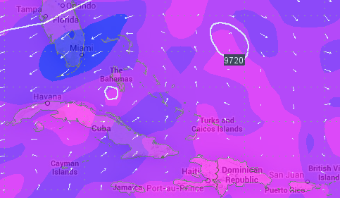
Updated…Reports from an Air Force Reserve Hurricane Hunter aircraft and satellite imagery indicate that the disturbance located near Hispaniola continues to lack a well-defined surface circulation. As a result, advisories are not being initiated at this time. However, environmental conditions are favorable for the development of a tropical depression or tropical storm later today or Sunday. Another Air Force Reserve Hurricane Hunter aircraft is scheduled to investigate the system this afternoon.
This disturbance is forecast to move west-northwestward over or near the southeastern Bahamas today, and over or near the central Bahamas Sunday and Sunday night. Heavy rains and gusty winds are expected to continue over Puerto Rico and Hispaniola today. Winds to tropical storm force and heavy rains are expected to spread over the
southeastern Bahamas, the Turks and Caicos Islands, and the central Bahamas through Sunday night. These rains could cause life-threatening flash floods and mudslides, especially in mountainous areas of Hispaniola and Puerto Rico. Interests in the Turks and Caicos and all of the Bahamas should monitor the progress of this disturbance, since tropical storm watches and warnings could be required with little advance notice.
* Formation chance through 48 hours…high…80 percent.
* Formation chance through 5 days…high…90 percent.
The Good
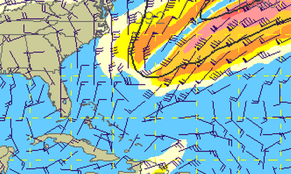
Most of the computer weather model output right now (a mixture of overnight and early morning model runs) keeps the storm track – if anything develops – out to sea.
And the development will be slow and very traceable. As it looks right now, meteorologists will be able to easily follow this storm during the next 72 hours.
The Bad
After about 48 hours out, not all of the models are on the same page. Here is a look a graphic of different models all put on the same map.

Notice that the lines really start to spread out after the 48 hour mark. This morning there are still three general conclusions – the storm is swept far out to sea, the storm barely grazes the coast of Florida, Georgia, and South Carolina, or It moves across Florida and into Georgia and Alabama
The Ugly
Regardless of strength and where ever it goes, it will be quite the rainmaker. Flooding is likely if it decides to head toward land.

So, What’s Going on Here… Give Me the Deets!
Right now, wind shear is keeping the storm disorganized. Wind shear is a change in wind speed and/or direction with height in the atmosphere. So while at the surface Invest 96L is moving west-northwest at 10mph, the winds above the storm are actually moving from the southwest at 20 to 30mph in some places and back from the northeast at 30 to 40mph in others.
That means the cloud tops get peeled off to the side. That is very bad for the health of a developing hurricane. Tropical systems want little to no wind in the atmosphere above it. That allows storms to develop freely, without interference.
I know what you might be thinking, too. Sometimes you hear meteorologists talk about shear as a “good” thing for storm development – like during the spring months. Well because severe thunderstorms and tornadoes are completely different types of systems (despite what your 8th grade science class may have taught you) they require different environments to grow.
So, for the next 6 to 18 hours, with the shear in place, the development of Invest 96L into a tropical depression or tropical storm will be drastically inhibited.

There is another piece of info meteorologists are watching right now, too: There isn’t much in the way of a center to Invest 96L, either. Oh sure, there is a middle. But not much in the way of low-level circulation – or a center. In order for a tropical depression / tropical storm / hurricane to be what it is, it needs to have low-level circulation. That helps keep it alive and helps it strengthen. It brings in warm tropical air to the center by wrapping it around an area of low pressure at the surface. And because the pressure is low at that point it allows the air to rise, quickly, to form the strongest storms right around the center.
Until Invest 96L has a defined center, it will be just a cluster of storms.
The other thing we’re keeping an eye on is the placement and interaction between the big ridge of high pressure in the middle of the Atlantic and an incoming trough of low pressure from the Midwest.
The track of Invest 96L is very dependent on the interaction between the ridge and trough.
Often times when any tropical system moves toward the east coast, a trough – or cold front – is what takes it back out to sea. You hear meteorologists say things like, “It will get caught in the Jet Stream and pushed out to sea” or “This next cold front will likely move it up the coast and keep it out of harms way”
At this time, some computer weather models show the big ridge getting squeezed down and pushed to the south by the trough by Monday. That means the trough will be closer to Invest 96L and will be able to “pick it up” in a way and carry it back out to sea. But the concern right now is that the trough won’t squeeze enough and ridge will hang tough and allow the storm to continue to move west or northwest into the US coast.
Until the computer weather models come into better agreement, we can’t give a 100-percent accurate forecast.
So You’re Tellin’ Me There’s a Chance
Right now, beyond the next 48 hours, Invest 96L is creating quite a headache for forecasters. But there is a chance it develops into a tropical storm or hurricane. There is a chance that is may threaten the Florida coast.
And there is a chance that it stays out to sea, where all hurricanes belong.
In the end, I have a sneaking suspicion that it may graze the coast before getting swept out to sea, but I think the NAM and the ECMWF are probably the best computer weather models to follow this morning. Invest 96L slowly trudges northwest then north and then back out to sea while perhaps pushing some feeder bands (the storms that wrap around the outside) in over parts of Florida, Georgia, and the Carolinas. But no “direct hit” seems like a more possible solution from all of this.
That said, Invest 96L will slowly figure out what it is trying to do while meteorologists quickly work to determine its track.


