Severe weather is possible this week as this very “spring-like” pattern falls apart Monday, Tuesday, and Wednesday.
Recall last week when I mentioned that this Tuesday and Wednesday could look similar to – what I was forecasting at the time – last Thursday and Friday.
It still looks that way. Only in reverse.
Right now, models indicate the threat for severe weather will continue across the TExas and Oklahoma panhandles Monday, Tuesday and Wednesday before shifting east by Thursday.
The main bulk of the severe weather threats will be damaging wind, large hail and isolated tornadoes.
Quick Breakdown
The southern plains remains in a southwest flow aloft with an area of low pressure to the west. As has been the case for the past four days, this pattern will continue to hold the door open for scattered showers and thunderstorms to develop.
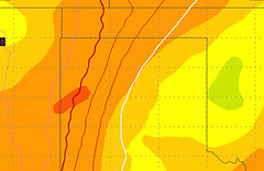
Dryline indicated by red/white lines
The main bulk of the severe action will be relegated to along the dryline. This is where hot dry air interacts with warm moist air and acts as a focal point for convection to begin. The surface convergence forces air upward and can eventually lead to cloud development.
Right now, all of the models are suggesting very isolated storms for Monday. In fact the WRF, RAP and RPM short-range, high-res computer weather models all suggest only a few very isolated cells with no major developing storms.
The NAM computer weather models wants to break out a handful of showers and thunderstorms along a line from Elk City, Oklahoma to Lubbock, Texas. Along with a few isolated cels around Stratford, Texas, too.
Often, I’ll favor the high-res short-range models, but today I think the NAM might be handling things better. The past few days we have watched convection fire here and there and I don’t know if I con completely rule out a shower or storm today.

Tuesday looks to be a little more active. The aforementioned WRF computer weather model wants to break out multiple discrete supercells across the Texas panhandle. The RPM does as well.
If storms do develop as predicted they would be severe. The predicted atmospheric soundings show CAPE values between 500 J/kg and 4,000 J/kg and bulk shear (surface-500mb) values between 25kts and 45kts.
Because of that, if storms do develop on Tuesday they could have very large hail.
Most of the computer weather models have all of the action to the east of a line from Guymon, Oklahoma back south toward Hereford, Texas. That said, the places where the atmosphere is most ripe for severe weather will be northeast of a line from Borger, Texas to Matador, Texas.
Wednesday is a bit of a mystery right now because it will be highly dependent on convection on both Monday and Tuesday. There is a chance that we could “spend” all of the atmospheric energy and be left with a few strong to marginally severe storms on Wednesday.
As it looks now, the atmosphere doesn’t look quite as conducive for severe weather development on Wednesday. Most of the models are suggesting showers and storms, but with CAPE values between 200 J/kg and 2,000 J/kg and bulk shear (surface-500mb) values between 10kts and 25kts.
While that doesn’t scream severe weather, but it also doesn’t point to benign conditions, either.
We’ll have to wait and see what happens Monday and Tuesday before we can get a good handle on what Wednesday will bring.
As always, we’ll be watching it closely.


