In the past 24 hours things have gotten whiter. A lot whiter. At this time yesterday, we were looking at the chance for some rain showers and a rumble of thunder or two. The GFS, EMCWF and our RPM computer weather models all suggested – roughly – the same thing. Only the NAM computer weather model suggested the infiltration of “cooler” air with temps in the 30s and 40s in some of our northeastern counties.
Turns out, the NAM might have been the most correct. Right now, all of the other computer weather models are starting to look a lot like the NAM did yesterday. And the NAM is looking even colder.
Based on this, I’m thinking the forecast for tomorrow will be heavily predicated on your location. Some spots will see rain while others get a rain/snow mix and few places will be mostly snow. I’m still confident that EVERYWHERE will switch over to – at least – a rain/snow mix at some point tomorrow with how cold we will be. The only place looking at all rain will be points south of a line from Clarendon to Clovis.
So here is the breakdown.
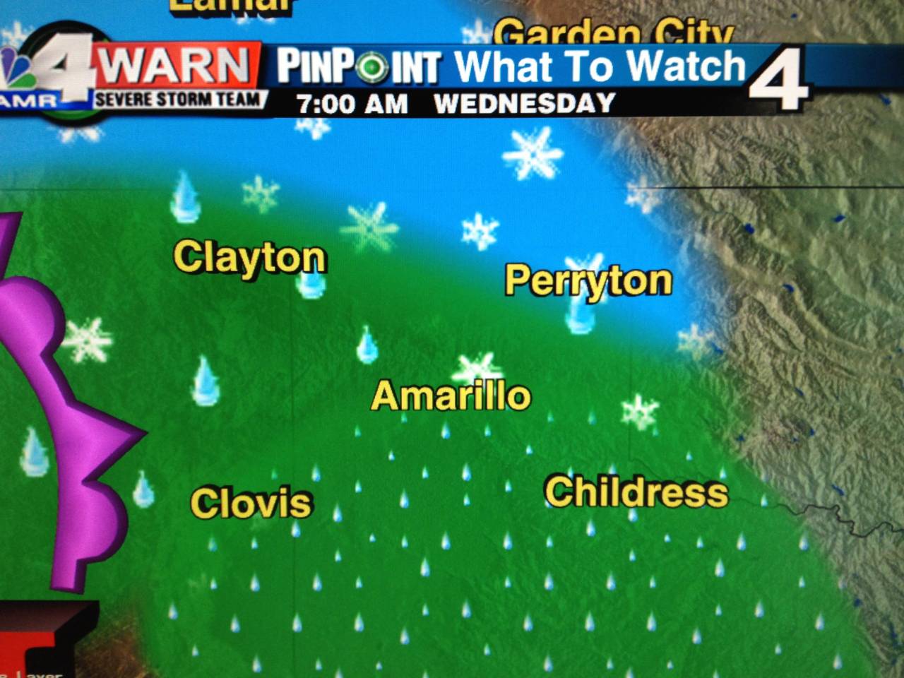 As the next system approaches moisture will increase out ahead of it. A few spotty showers will begin after midnight tonight. And the shower activity will increase as we head toward sunrise. We will start off with rain here in Amarillo and a rain/snow mix north of town with plain snow in some of our far northern counties.
Temperatures by sunrise will be hovering in the mid 30s area wide. Those places with colder air throughout the atmosphere will start with all snow, those with warmer air aloft, will get rain.
The graphic above indicates the TYPE of precipitation at a given location, not the coverage. Showers will be widely scattered, but we won’t be socked in with moisture in the morning.
As we move through the morning and toward the noon hour more of the colder air will settle further south. I think we’ll still manage to warm up in most spots, but the warming will be quite marginal. Temperatures will climb from the mid 30s to the upper 30s at best. Some places might not change more than a degree or two.
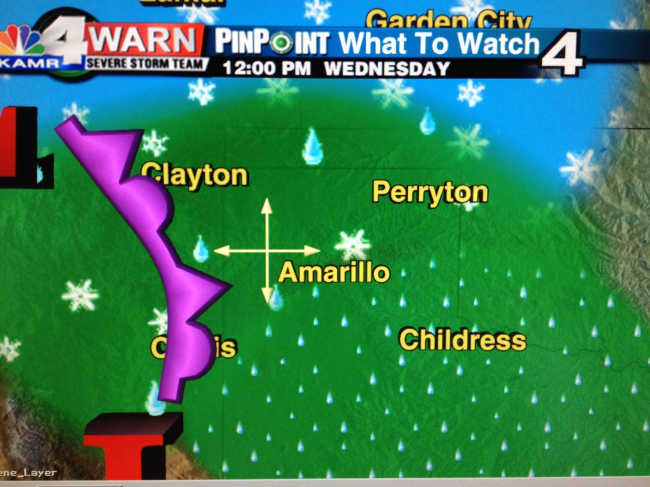 The precipitation will increase in coverage and in severity. The graphic to the right, again, indicates precipitation type and not coverage. Notice that with more of the colder air infiltrating that Amarillo has changed to a rain/snow mix but also with the increased southeasterly flow, Perryton has changed from an all-snow morning to a rain/snow mix.
It’s looking like at the noon hour, the delineation between rain and rain/snow will be on a lin from Wheeler southwest to Tulia.
As we head toward the 5 o’clock hour, the colder air will continue to hold onto some of our northern and eastern counties.
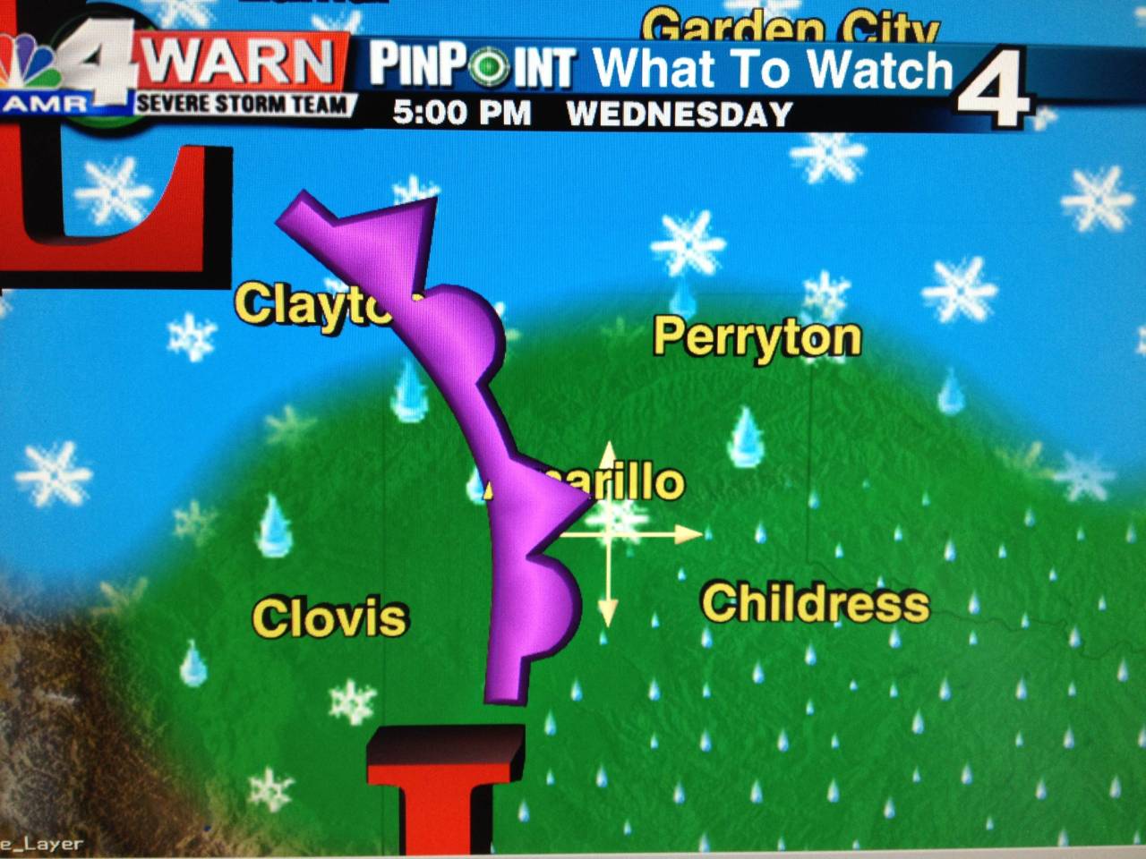 At this point, it’s looking like Guymon, Perryton and back toward Clayton all make the switch BACK to all snow. While most of us to the south continue with a very cold rain or rain/snow mix.
Again, the graphic on the left is precipitation type and not coverage. At this point in time, it’s looking like the moisture will run dry in Clovis, but if any showers were to survive, they would fall as a rain/snow mix.
As we head into the overnight hours the system pushes through and we are left with wrap-around moisture. Colder air will spill in behind the area of low pressure as it moves through and most spots on the map will then switch to all snow as a precipitation type.
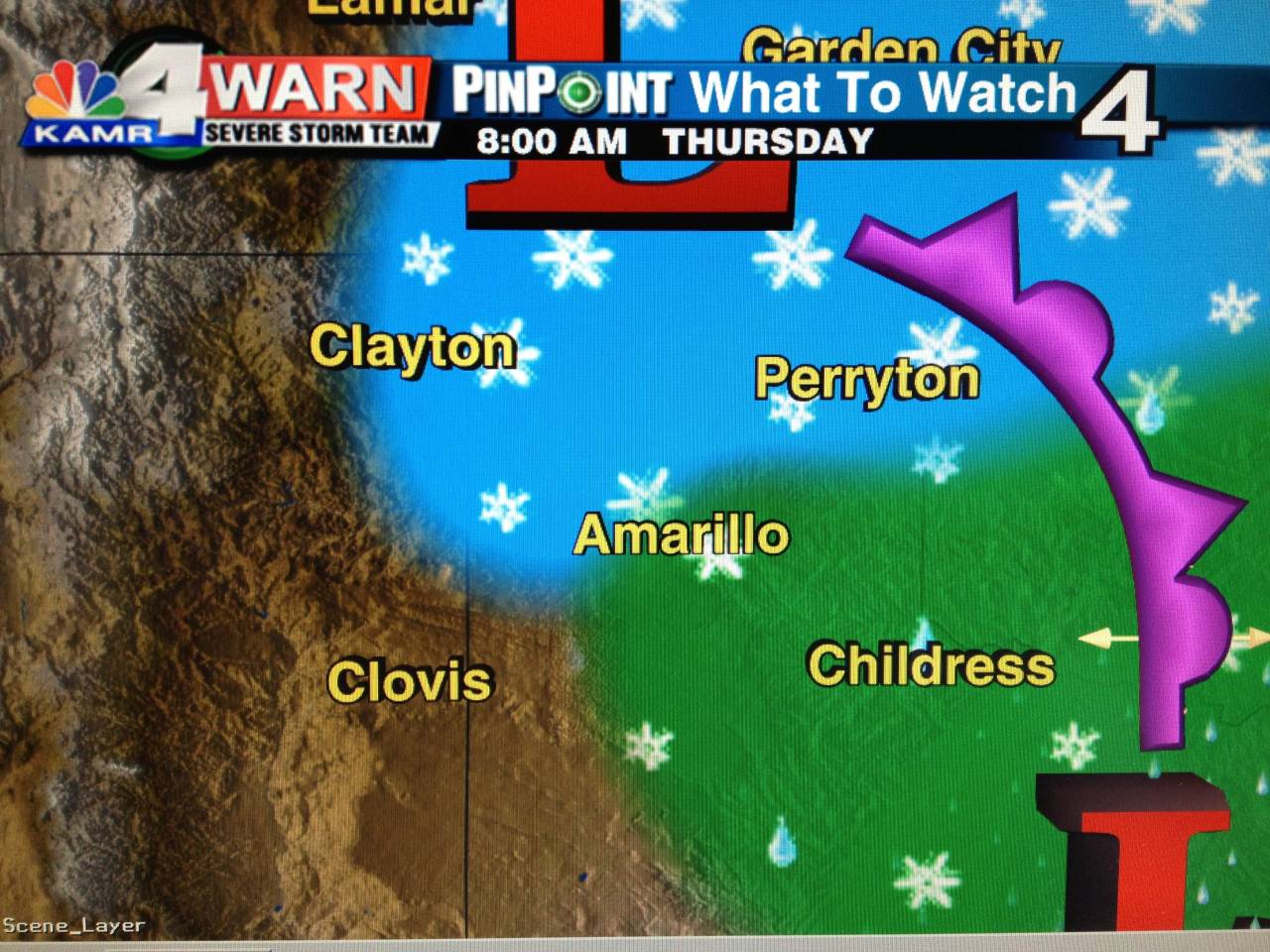 By Thursday morning only a few remnant flurries and light snow showers will be left over, but at that point most spots will have picked up some beneficial rains or some good snow.
Temperatures on Thursday will be highly dependent on snowpack. If you were one of the lucky places that picked up a little bit of snow you will be a bit colder.
Speaking of snowpack, how much are we looking at? Well, I still think areawide we probably won’t accumulate more than 2″ to 3″ of snow. The deepest will be to the north and east. Places like Beaver, Perryton and Higgins will most likely see the most snow. Here in Amarillo by the time Thursday morning clears out, it looks like a light dusting to a half-inch of snow could be realized on the grass and exposed porches and decks.
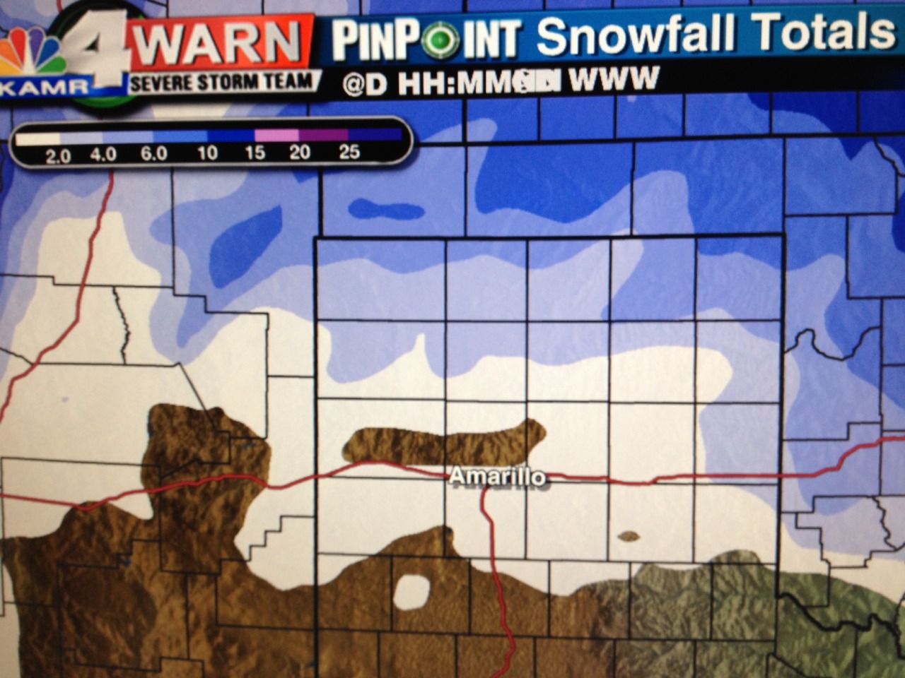 But. I will also say that more snow could be in the cards. Our in-house model is suggesting a colder, snowier scenario.
It suggests Amarillo will get less than 2″ of snow, sure. But look at Guymon, Beaver, Perryton and Boise City! It suggests 4″ to 6″ of the white stuff! Even up to 8″ locally in some areas!
But, with that being said, I still think, based on other computer weather models and with how much of this looks like it will be falling as a rain/snow mix, we will only accumulate between 2″ and 3″ of snow in those areas.
Of course, as always, I’ll be watching it closely!


