UPDATE 11:55am: The SPC is now considering a tornado WATCH for sections of the area. Details here
The SPC is recognizing the evolving nature of this severe weather event and moved the areas of concern for this afternoon farther south.
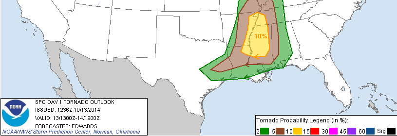
The 10 percent tornado threat now looks like it noses into northwest sections of the Pine Belt.
And while you are looking at this tornado risk map, one thing to keep in mind is that this doesn’t read exactly like a forecast map for rain. If there is a 2 percent or 5 percent chance for rain, you likely wouldn’t care. But when there is a 2, 5 or 10 percent risk for a tornado in a given area, it is worth paying close attention.
Because keep in mind that means you are 2, 5 or 10 times more likely to see a tornado in that area during that time than on any regular day.
The timing for storms is evolving, too. IIf you caught my 10pm weahtercast last night I mentioned that I was waiting for run-to-run consistency before changing the timing…. Well it looks like the models are being more consistent now. And they are all moving the line into our neighborhood sooner.
Here is a look at the HRRR, RPM and WRF sugested radar for 7pm tonight:
So while I still think there will afternoon storms – some severe – with rain wind and lightning, it looks like the main event is now pegged to get here later tonight between 8pm and 10pm and linger into the overnight hours
A brief timeline:
2pm – 7pm
Scattered storms. These won’t be as severe, but could pack some gusty wind, frequent lightning and could possibly spawn a brief and very weak tornado. These will develop ahead of the line and these are difficult to predict where they will form.
7pm – 2am
A line of strong to severe storms will move through the entire area. Everywhere will see rain, wind and lightning. A few isolated tornadoes cannot be ruled out within the line. These storms will move from west to east across the area and will likely pack winds exceeding 60mph and rainfall rates above 1.0″ per hour.
If you live across southern Mississippi and you aren’t on the immediate coastline, yes, you will see this line of storms move through your area.
More info on social media
I will have more information as all of the 12z computer weather models render as well as the 15z and 18z models, too. I’ll be updating the facebook page, the station facebook page, my personal facebook page and twitter through the rest of the day, but may not be able to post an update here. Please find me on social media for the very latest info!


