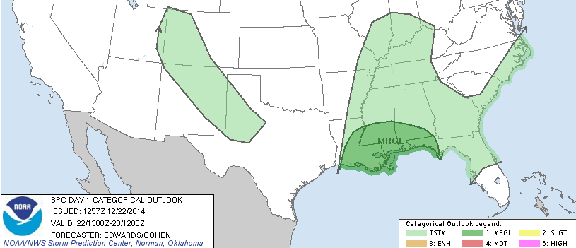
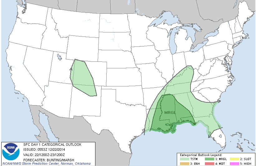
UPDATE 9:00 AM: The NWS SPC has updated the forecast graphics for today. They have removed the mention for severe hail and moved the “Marginal” risk farther south.
The surface observations show most of the region with winds from the east or northeast. In other words, the warm front that will push north across Louisiana, Mississippi and Alabama is still off the coast. Severe storms won’t develop until that warm front pushes north, as the warm Gulf moisture behind it is the catalyst for storm development. It looks like that warm front will push through the coastal regions around 10am and through the I-20 corridor around 3pm.
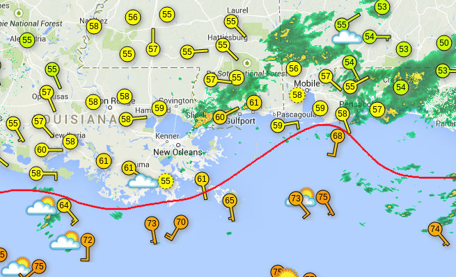
While the radar does show some storm development, severe storm development won’t occur until the warm front passes and dewpoints rise above the 60 degree mark.
From the NWS SPC:
At least weakly favorable parameter spaces and conditional risk of damaging gusts/tornadoes will exist across this region throughout latter 12-15 hours of day-1 period — from late aftn onward. However…Lack of substantial deep-layer lift and weakness/absence of low-level foci indicate very sparse coverage of sfc-based Tstms…Keeping unconditional probabilities mrgl attm.
Deep shear will be increasing over this region throughout period…As will low-level moisture and thetae. Moreover…Somewhat enlarged/loopy low-level hodographs likely will develop invof warm front. Subtle large-scale ascent is expected mainly n of i-20 over corridors of weak elevated instability…In relation to right-entrance region of strengthening jet aloft…Contributing to elevated thunder potential over mid south and oh valley. However…Ascent/destabilization aloft related to mid-upper-level dcva likely will remain displaced from most favorable low-level thermodynamic fields this period. Moreover…Support for sustained/deep convection is lacking given… 1. Shallow slope of warm front… 2. Lack of apparent/additional mesoscale foci to augment low-level lift over delta/gulf coast region…And 3. Likelihood of weak midlevel lapse rates and stable layers aloft per 12z lch raob and multiple model-fcst soundings.
Sfc dew points mid-upper 60s f may offset those poor lapse rates enough to result in 500-1000 j/kg mlcape near coast after dark…Though sources for low-level forcing appear weak/uncertain attm. Some potential also exists for small supercells to form within relatively weakly capped and highest-thetae air mass over gulf late in period…Moving ewd toward coast. Prind greatest concentration of any such convection will remain offshore through period…Though one or two such tstms cannot be ruled out tonight over coastal areas from fl panhandle wwd across sern la.
ORIGINAL POST: The atmosphere is still looking charged to produce at least some severe weather Monday and Tuesday across sections of Arkansas, Louisiana, Mississippi, Alabama and Florida. The National Weather Service Storm Prediction Center, NWS SPC, issued a “Marginal” risk for severe weather Monday and a “Slight” risk for Tuesday.
SPC Says…
Here is what the NWS SPC is currently thinking for Monday:
Some variability persists among numerical guidance regarding the location of the warm front…Initially just south of the central/eastern gulf coast…During the day monday. Most likely scenario is for the warm front to extend from central/northern mississippi into southern alabama/georgia by monday evening. North of the warm front…Modest elevated instability will exist with mucape of 250 to 500 j/kg during the afternoon/evening. With generally weak isentropic ascent and large-scale lift with the initial shortwave remaining north of the area…Only isolated thunderstorms are expected. Effective bulk shear of 50-60 kts suggests a risk of marginally severe hail/wind will exist with the strongest storms. Near and south of the warm front…Lower to mid 60s surface dewpoints will advect northward during the day and contribute to mucape of 500 to 1000 j/kg in the presence of 40-50 knots of effective bulk shear. Low-level srh will be maximized near the warm front…And any storm that develops would pose at least some wind/tornado threat. However…With the strongest height falls/forcing for ascent with the southern shortwave remaining upstream…Thunderstorms should remain isolated in this area until after 12z tue.
The main threats with storms on Monday will be heavy rain, damaging winds, hail and isolated tornadoes. Both model guidance and the CIPS historical guidance suggests that any isolated tornado would likely remain below EF-1 strength.
Timing
Monday Morning: Showers and fog. Maybe a rumble of thunder
Monday Afternoon: Hit and miss storms firing across southern sections of Louisiana, Mississippi and Alabama. These storms would move north or northeast and have the potential to turn severe. Due to the atmospheric setup, storms that are able to become established and remain discrete would have the greatest chance to turn severe and produce a tornado. The main threats are heavy rain, hail, damaging straight-line winds and isolated tornadoes
Monday Night: Continued isolated thunderstorms for eastern Arkansas and Louisiana, most of Mississippi, westner Alabama, and the Florida panhandle. A few could be severe. The main threats – at this time – would be shifting to heavy rain, straight-line wind and brief, and weak, isolated tornadoes.
Tuesday Morning: A continued chance for thunderstorms – some that could be severe – with more coverage of storms for the entire region. The main threat at this point would switch to heavy rain, some localized flooding, and damaging straight-line winds. The threat for a tornado at this point is lower, but not zero, because current model guidance shows that hodographs wouldn’t be as favorable for tornadic development. It is something I’m watching very closely.
Tuesday Afternoon / Night: More details coming later. Right now, the afternoon and evening forecast is going to be determined by how much convection the area sees through the next 24 hours.
Before I go
Based on the current model guidance and trends, I wouldn’t be surprised if the NWS SPC moved a small section of southeastern Louisiana, south central Mississippi and extreme western Alabama into a “Slight” risk later today.
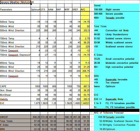
The numbers