A plume of monsoonal moisture continues to traverse sections of eastern New Mexico and the western Texas and Oklahoma panhandles this afternoon and evening.
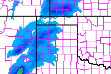
So far, radar estimates show between one and three inches of rain across the region. Because the moisture is tropical in origin, according to the National Weather Service, the radar estimates are likely undercutting the possible rainfall totals.
Earlier this afternoon the National Weather Service even issued a Flash Flood Watch for some areas given the rainfall rates and the predicted length of the rain event.
From the National Weather Service Chat:
We issued the flash flood watch because locations near Texline have already received upwards of 3″ of rain since last night, and we expect much more to fall through Friday evening in these locations. The showers and occasional storms will be very efficient precipitation producers, so the potential for 1″/hr rain rates will be common at times.
Right now, it looks like the rain will stick around through Friday as sub-tropical moisture interacts with a frontal boundary draped to the north of the Oklahoma panhandle.
According to the NAM computer weather model the highest rain totals will be relegated to the northwestern counties of the Texas panhandle, the Oklahoma panhandle, western sections of Kansas and parts of Colorado and New Mexico.
Most of the computer weather models keep the front north of the Texas panhandle, but should it slide south it would increase the rain chances for those areas farther south, too.
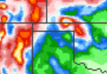
The one computer weather model worth noting is the Texas Tech University WRF model. Often, it has a pretty goo handle on high plains weather and right now it is doing its best impression of McKayla Maroney (unimpressed).
The latest TTU-WRF leaves the area mostly dry even through tomorrow afternoon. It keeps most of the rain through tonight and tomorrow in sections of central and eastern New Mexico, parts of Colorado and Kansas. To the right is a look at what it suggests tomorrow afternoon will look like across the area.
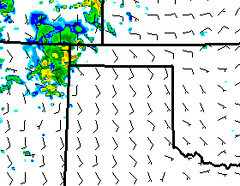
It will be interesting to see how all of this progresses through the evening tonight and into tomorrow. There is a slot of dry air in western New Mexico that, if it moves through, could cut off the area’s rain chances much like the TTU-WRF suggests.


