UPDATE (1/21/15 @ 9:55am): Snow totals are being increased for some western counties and the snow will being slightly earlier than anticipated for some areas of the northern Texas panhandle.
Snowfall estimates:
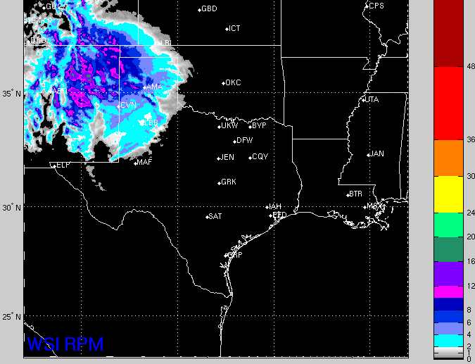
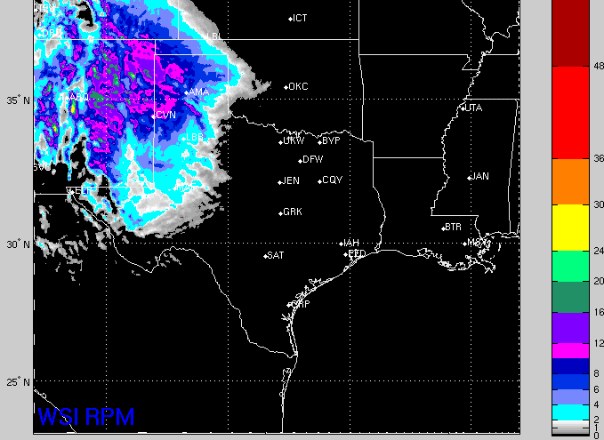
- 8″ to 14″ of snow in eastern New Mexico and the western Texas panhandle – places like Clayton, NM, Tucumcari, NM, Clovis, NM, Dalhart, TX, and Herefored, TX.
- 6″ to 10″ of snow for the central and western Oklahoma panhandle and the central and southern Texas panhandle – places like Boise City, OK, Guymon, OK, Stratford, TX, Dumas, TX, Amarillo, TX, Canyon, TX, Tulia, TX, and Plainview, TX.
- 3″ to 5″ of snow in the northeastern Texas panhandle and sections of west Texas – places like Perryton, TX and Canadian, TX as well as Lubbock, TX.
- 2″ to 4″ of snow for the other eastern sections of the Texas and Oklahoma panhandles – places like Beaver, OK and Shamrock, TX.
Within the areas above there will be isolated spots that pick up more snow. Here is a look at the latest estimates from the RPM computer weather model…
Other than that, this forecast is on track.
ORIGINAL (1/20/15 @ 4:52pm): The next system to drop out of the Rockies is looking like it will pack quite the wallop for sections of southeastern Colorado, eastern New Mexico, the Oklahoma panhandle, southwestern Kansas and the Texas panhandle as well as parts of west Texas.
What will likely start out as a cold rain for sections of the area will turn to snow and stay as snow from Wednesday morning through Thursday night. The snow will build in from the northwest and eventually clear to the south.
The Breakdown
The pictures below illustrate the Vertical Velocity, the surface wind, and the suggested radar from the 12z NAM computer weather model. In the suggested radar graphic, everywhere to the west of the red line will be mainly all snow while to the east there will be a mix of rain and snow.
The biggest concern is the development of heavier snow bands where the surface, upsloping wind ends up underneath the area of the highest vertical velocity (shown in the red). Where this happens, along with a few other parameters, there will be a tendency to produce heavier snow bands. Underneath these bands, locally heavy snow may develop. Areas may pick up an additional one to three inches of snow as compared to places nearby.
There will also be a wind of 10 to 20 mph so locally reduced visibility will be likely, too.
Timeline
WED 2AM: Light rain / snow begins to fall NW of a line from Tucumcari, NM to Guymon, OK.
WED 7AM: Light snow begins to fall NW of a line from Tucumcari, NM to Beaver, OK. Now, light rain begins to fall NW of a line from Clovis, NM to Perryton, TX.
WED 12PM: Moderate snow begins to fall across NE New Mexico, the western Texas and Oklahoma panhandles. Light rain continues along the edge of the snowfall line and to the SW to a line from Clovis, NM to Beaver, OK.
WED 5PM: Moderate snow continues in the areas above, while light rain/snow begins to push south toward Lubbock, TX.
WED 10PM: Moderate snow continues for the areas listed above and begins for places that were getting a rain/snow mix. Light snow moves south into Lubbock, TX and surrounding areas. Rain continues to the south and east.
THU 2AM: Moderate snow continues for the areas listed above. Light snow stalls around Lubbock, TX. Light rain continues to the south and east.
THU 7AM: Snow will be falling NW of a line from Vernon, TX to Roswell, NM. A rain/snow mix will fall near and to the south of that line. Turning to rain farther south.
THU 12PM: Snow ending for the Oklahoma and northern Texas panhandle. Light snow continues in the mountains of eastern New Mexico and along the I-40 corridor. Moderate snow tapers to light snow to the south of I-40.
THU 5PM: Most of the snow is now south of I-40. Snow is falling NW of a line from Midland, TX to Childress, TX but south of I-40. Light rain continues east of that line.
In a nutshell
If you have plans to travel, and you can delay those plans, it is recommended.
Overall the area is likely to see between 2″ to 4″ of snow to the east and between 6″ and 8″ to the west. Higher totals likely in the NW counties of Texas and the NE counties of New Mexico. Some places could see up to 15″ of snow.