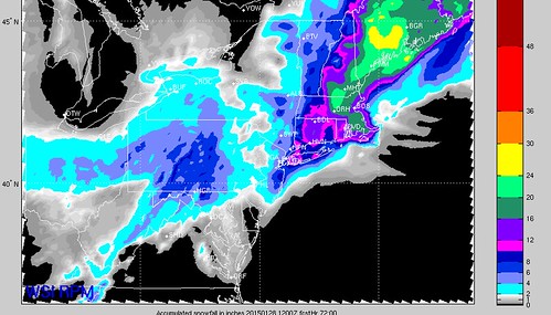
UPDATE (1/25/15 11:00pm): Here is the latest graphics from the 21z SREF (for Boston and NYC), 0z GFS and 0z NAM:
It will be interesting to see where the most intense snow bands occur. Depending on which model you look at, you get a little bit of a different answer.
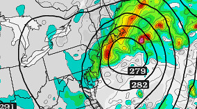
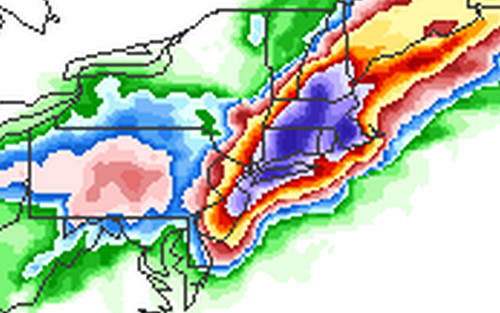
The 0z NAM seems to have a decent handle on where the most vertical velocity at 700mb may decide to setup.
You can see here that at 9z and 12z there is substantial vertical motion just along the coast of New Jersey, New York, Connecticut, Rhode Island, and Massachusetts.
Where you have the most vertical motion is often where you see the heaviest snow bands as this is the area with the most lift.
Notice, though, that in both the 9z and 12z pictures that the strongest vertical velocity is just off-shore.
This could save some areas from truly getting pummeled.
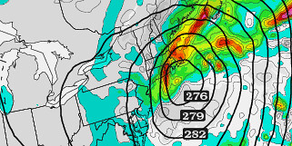
But don’t bet on it.
Right now it looks like a safe bet for between 6″ and 36″ of snow depending on location. The heaviest snow will be in the areas under these heavier snow bands.
The image at the bottom of this page is a rough estimate of our forecast for snow totals. It was issued this morning at 9am and still holds true.
UPDATE (1/25/15 7:45pm): Here is the latest graphic from the National Weather Service office in Boston…
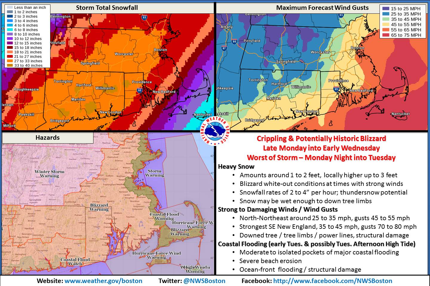
This won’t be a typical storm breakdown, as this isn’t a typical storm – in terms of impacts. A Blizzard Watch was issued by the National Weather Service from roughly New York City to Boston and all points between and nearby. That means that the weather will include snowfall, visibility below 1/4 mile due to blowing snow, and winds in excess of 35mph. Continuously. For more than three hours.
If you live in the north of Baltimore and close enough to the Atlantic Ocean to drive there – without traffic – within about two hours you will likely see these, or worse, conditions.
Per the National Weather Service:
...BLIZZARD WATCH IN EFFECT FROM MONDAY AFTERNOON THROUGH TUESDAY
EVENING...

THE NATIONAL WEATHER SERVICE IN NEW YORK HAS ISSUED A BLIZZARD WATCH...WHICH IS IN EFFECT FROM MONDAY AFTERNOON THROUGH TUESDAY EVENING.

* LOCATIONS...THE GREATER NEW YORK CITY METROPOLITAN AREA.
* HAZARD TYPES...HEAVY SNOW AND BLOWING SNOW...WITH BLIZZARD CONDITIONS LIKELY.
* ACCUMULATIONS...SNOW ACCUMULATION OF 1 TO 2 FEET...WITH LOCALLY HIGHER AMOUNTS POSSIBLE.
* WINDS...NORTH 20 TO 30 MPH WITH GUSTS UP TO 50 MPH.
* VISIBILITIES...ONE QUARTER MILE OR LESS AT TIMES.
* TEMPERATURES...IN THE LOWER 20S.
* TIMING...HEAVIEST SNOW AND STRONGEST WINDS WILL OCCUR OVERNIGHT MONDAY INTO TUESDAY.
* IMPACTS...EXTREMELY DANGEROUS TRAVEL DUE TO HEAVY SNOWFALL AND STRONG WINDS...WITH WHITEOUT CONDITIONS LIKELY. SECONDARY AND TERTIARY ROADS MAY BECOME IMPASSABLE. STRONG WINDS MAY DOWN POWER LINES AND TREE LIMBS.

PRECAUTIONARY/PREPAREDNESS ACTIONS...

A BLIZZARD WATCH MEANS THERE IS A POTENTIAL FOR FALLING AND/OR BLOWING SNOW WITH STRONG WINDS AND EXTREMELY POOR VISIBILITIES. THIS CAN LEAD TO WHITEOUT CONDITIONS AND MAKE TRAVEL VERY DANGEROUS.
...BLIZZARD WATCH IN EFFECT FROM MONDAY EVENING THROUGH LATE TUESDAY NIGHT... THE NATIONAL WEATHER SERVICE IN TAUNTON HAS ISSUED A BLIZZARD WATCH...WHICH IS IN EFFECT FROM MONDAY EVENING THROUGH LATE TUESDAY NIGHT. * LOCATIONS...EASTERN MASSACHUSETTS AND RHODE ISLAND. * HAZARD TYPES...HEAVY SNOW...STRONG WINDS AND BLIZZARD CONDITIONS. CONSIDERABLE BLOWING AND DRIFTING SNOW. * ACCUMULATIONS...SNOW ACCUMULATION OF 18 TO 24 INCHES. * TIMING...THE WORST OF THE STORM WILL BE MONDAY NIGHT THROUGH TUESDAY AFTERNOON. * IMPACTS...HEAVY SNOW AND STRONG WINDS WILL RESULT IN THE POTENTIAL FOR BLIZZARD CONDITIONS WITH NEAR ZERO VISIBILITY. ALONG THE SOUTHEAST NEW ENGLAND COAST...THE SNOW MAY BE WET ENOUGH TO RESULT IN SOME DOWNED TREE LIMBS AND POWER OUTAGES. TRAVEL MAY BECOME IMPOSSIBLE AND LIFE THREATENING ACROSS THE ENTIRE REGION. THIS HAS THE POTENTIAL TO BE A HISTORIC STORM. * WINDS...NORTH 20 TO 30 MPH WITH GUSTS UP TO 60 MPH. * TEMPERATURES...IN THE LOWER 20S. * VISIBILITIES...ONE QUARTER MILE OR LESS AT TIMES. PRECAUTIONARY/PREPAREDNESS ACTIONS... A BLIZZARD WATCH MEANS THERE IS A POTENTIAL FOR CONSIDERABLE FALLING AND/OR BLOWING SNOW WITH SUSTAINED WINDS OR FREQUENT GUSTS OVER 35 MPH AND VISIBILITIES BELOW 1/4 MILE FOR AT LEAST 3 HOURS. WHITEOUT CONDITIONS WILL BE POSSIBLE...MAKING TRAVEL VERY DANGEROUS. BE PREPARED TO ALTER ANY TRAVEL PLANS.
In a nutshell, travel is highly discouraged and preparations are highly encouraged. The Weather Channel is calling it Juno, most everyone else is calling it Suck-O.
Looking at the available forecast models, the snow machine will be full throttle. Most of the American computer weather models are kicking out between 6″ and 24″ of snow between Monday afternoon and Wednesday morning for most of the Northeast.
Below is the snowfall totals from the SREF computer weather model for the NYC Metro area.
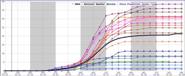
The spread here is normal. This is the SREF Plume View and it takes a bunch of different variables into account and spits out a bunch of extra data. The line to look at here is the black line. For those who want to live dangerously, you could make the argument that any of these lines could happen, but that’s not exactly the point of the model.
That said, keep in mind, that any of those lines… could happen.
There is some good news, though it is mixed with some bad news. The good news is that a few of the models take this system farther north before it slows down. That would put all of the dreadfully deep snowfall into Inland Massachusetts, Vermont, Connecticut and Maine.
The RPM computer weather model, for example, does this.
But don’t bank on that. Plan for the worst, hope for the best. The flip-side to that RPM model is the GFS. It slams NYC, Boston and surrounding communities with more than 20 inches of snow.
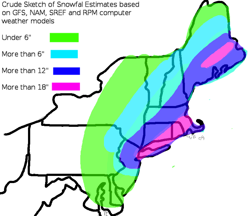
Based on all of the American models, here is a rough sketch of what snow totals may look like by the time things are all said and done for the Northeast. This map does not include snow totals for sections of Pennsylvania and West Virginia.
And please remember that it isn’t just the snow. There will be winds gusting more than 50mph and visibility will be reduced to less than one-quarter of a mile. Snow drifting is likely and power outages are almost a guarantee. Please get the necessary things together to brave this storm. Don’t wait until the power goes out to find your flashlights or get some wood in the fireplace.


