If you live across the Texas and Oklahoma panhandles, enjoy temperatures in the 80s and 90s today, tomorrow and Thursday.
But buckle up for Friday, Saturday and Sunday.
Scenario
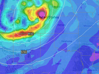
As it looks right now a strong autumn system will push through the upper-Midwest and open the door for a cold front to bring the coldest temperatures of the year to the area. Some places by Sunday morning could be hovering around the freezing mark.
Latest computer models suggest temperatures in the 30s.
Quick Breakdown
During the day on Friday an area of low pressure will glide by to our north and as it passes, it will open the door for much cooler air to spill across the area. Winds will shift from southwest to north and that shift will help usher in much cooler air. Now that it is October, it is becoming much easier for the cooler continental air mass to sag southward.
And boy howdy, will it!
By Friday afternoon winds from the north at 20 to 30mph with gusts to 45mph will shove all of the warmth south and the mercury will going into free-fall throughout the afternoon and evening.
Right now, while the forecast high temperatures are in the 70s, I would argue that it will likely be the same temperatures at breakfast and dinner on Friday for most places north of a line from Portales, New Mexico to Altus, Oklahoma.
That cooler air will stick around, too. As that cooler area of high pressure builds into the area, most places will wake up to the 30s and 40s Saturday morning. Then high temperatures on Saturday will only muster the 50s and 60s. Average highs on Saturday are will in the mid- to upper-70s!
By Sunday morning, some places are looking like they will wake up with frost on the ground. Perhaps even the first freeze of the year in places in northeastern New Mexico and southeastern Colorado!
By Sunday afternoon, though, the winds will begin to shift back to the southwest and a downsloping wind will help boost temperatures back to around average. And by Monday, seasonal conditions return… Before the next front pushes through.
For the Wx Curious
A strong autumn storm will press across the central plains and upper midwest this week and allow for the passage of a cold front through the area on Friday. This won’t be much of a “weather maker” for the high plains, outside of a windshift and much cooler temperatures.
That said, there is some disagreement between the weather models. The consensus is that a strong push of cold air will arrive Friday and into Saturday via gusty north winds at 20 to 30mph. The piece that is a little more up in the air (pun intended) is just how fast this system will move and if there is the chance for precipitation.
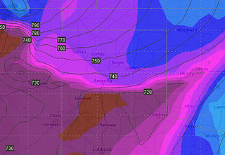
All of the computer weather models put the cold front north of the area by Friday morning and south of the area by Saturday morning – but between 7am Friday and 7am Saturday, the GFS, EURO, GEM, SREF and UKMET all have their own solutions.
The tendency at this point is to push the front through the northeastern sections of New Mexico by noon, the central Texas panhandle by 5pm and the southeastern Texas panhandle by 9pm.
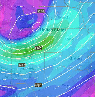
And the rain chances will be minimal. Two reasons, really. The first is the atmosphere aloft isn’t conducive to precipitation development. On the picture above, notice how the isobars are closer together? That indicates the atmosphere, at 300mb, isn’t “opening up” for air to rise and form clouds and eventually precipitation.
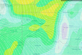
The other reason, as it looks right now, there won’t be much moisture available. Therefore, there isn’t the concern about rain, snow or severe weather.
Given the track of this area of low pressure, the high plains will be in the wrong quadrant for severe weather chances. The panhandles will be “dry slotted” and the available moisture will be too far east.
Take a look at this graphic. Where you see the purple indicates dewpoints below 30 degrees fahrenheit. Often, you need a dewpoint above 45 degrees fahrenheit
That said, if it digs a little farther to the south, the Texas and Oklahoma panhandles would be in a better place to see rain and thunderstorms. Or if there is enough available moisture behind the front as it passes, there might be a few rain showers across the area.
At this time, given the GFS and the Euro computer weather models depiction of where this low pressure will be moving, the chances for rain are slim and the chances for a windshift and cooler air are pretty high.


