The overnight computer weather model data just came down and things are starting to come into better focus, and while things are looking a little more *wintry* the majority of the information isn’t pointing to snow for southern Mississippi, Louisiana and Alabama.
Historically speaking
There isn’t much here. Pulling data from the Baton Rouge site, the Hattiesburg site, and Mobile site, there are two events that brought snow to all three sites at the same time. Once in January of 2014 and back in January of 1972.
That is a 40-year spread!
In terms of meaningful snowfall – more than a Trace – the three sites haven’t had much since 1970. Hattiesburg led the way with 12 such events. Mobile has tallied 10. Baton rouge came in last with just four.
I did some quick comparisons and there isn’t a pattern when compared to El Nino or La Nina. It seems as though Gulf Coast snowfall events have been relatively random during the last 40 years.
The strength of the El Nino or La Nina didn’t seem to matter either.
Enough history, tell me about the setup
An area of surface low pressure will move to the ENE across east Texas and into western Tennessee. As it does so, a cold front will push colder air south across parts of the lower Mississippi valley and toward the Gulf Coast.
Ahead of the cold front, temperatures will be in the 50s and 60s, aided by a southwest wind. Behind the front, temperatures will fall quickly from the 40s to the 30s.
The coldest air won’t be directly behind the cold front, but will barrel through the area overnight Tuesday and into Wednesday morning.
You were cold as ice…
While the threat for severe weather is diminishing according to the latest rendering from the GFS and ECMWF, the threat for wintry weather is on the rise across parts of northern Mississippi and Alabama, as well as Arkansas and Tennessee.
For the Gulf Coast, creating a winter weather scenario will be a matter of cooling the column of air while also maintaining saturation. And that doesn’t look like it will happen for very long – if at all.
Here is a look at the Tuesday 1pm Skew-T chart from the GFS for southern Mississippi, southwestern Louisiana and southeastern Alabama.
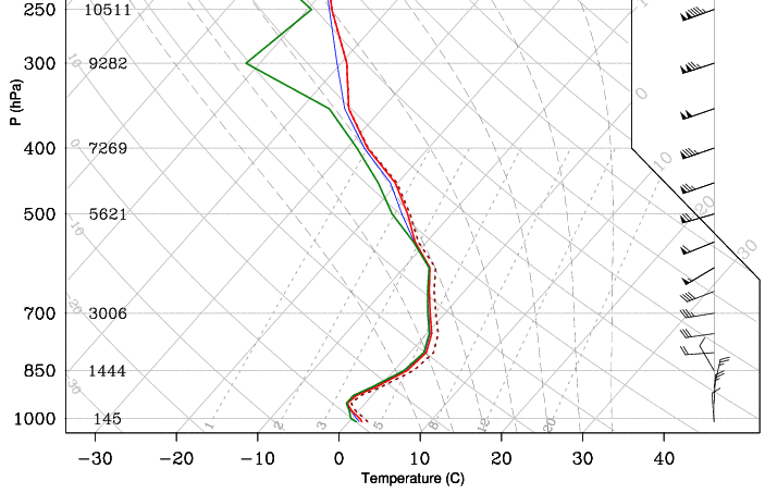
It shows a saturated column from the surface to about 550mb (16,000ft). And above 600mb the air temperature drops to -10C, still saturated, which means you can start to build snowflakes.
But from 925mb to 750mb in the atmosphere there is a layer of warm air. Converted over to altitude, that means there is roughly 5,500 feet of air above freezing that a snowflake has to fall through. And because that layer of warmer air is also saturated, it won’t likely be cooled much by any snow falling into it. So that layer will likely melt the snow.
But below 925mb and almost to the surface there is another layer of air that is back below freezing. This will likely re-freeze some of the melted snow and raindrops, creating some sleet pellets.
This will be short-lived, though.
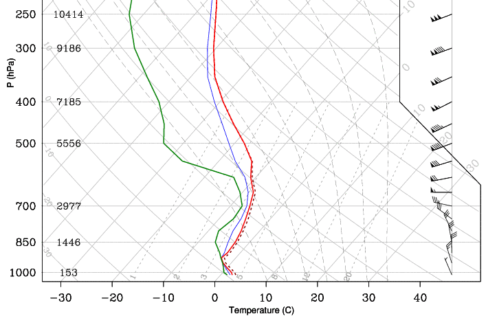
This is the Skew-T from 7pm Tuesday night. According to the GFS, the atmosphere is already starting to dry out – especially in the DGZ.
That said, the column of air is below freezing the entire way up. So if there is any snow to be made, it will remain snow all the way down to the surface. But at this point, there may not be enough moisture left to create any snow, sleet or even plain rain.
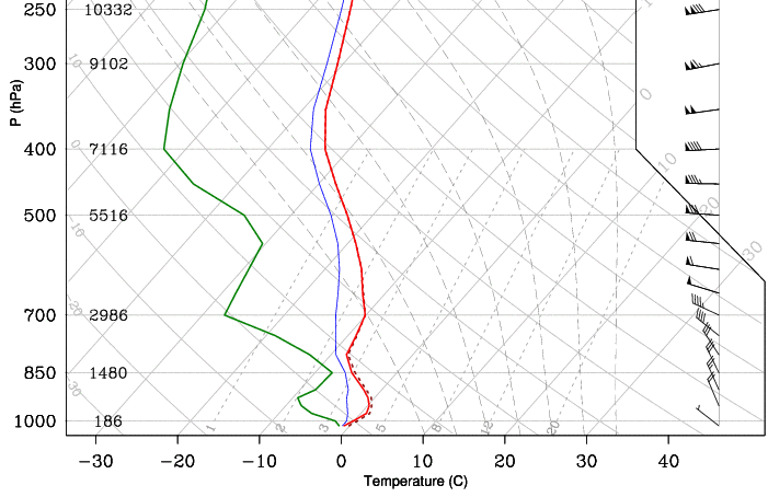
Beyond that, things really start to dry out and cool off.
Take a look at the 1am Skew-T:
These are just the Skew-Ts, too. We haven’t looked at Vertical Velocity, Frontogenesis, nor any simulated reflectivity.
But what about the Euro?
I have been using a lot of GFS maps, true. The European model is little less aggressive with the push of cold air and a little more temperate with the temperatures. Instead of the 50s to the 30s – it keeps most of the area in the 40s. Then brings the 30s and 20s in overnight and into Wednesday morning after all of the clouds and moisture exit the area.
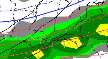
This is a look at what the European model suggests for Tuesday night at 6pm. On these precipitation maps there are a few things to notice. The first is this is a map of precipitation during the previous six hours, not a “radar” shot. It doesn’t differentiate between rain and snow. And the places with the yellows received a lot of liquid-equivalent rain in the previous six hours, while the lighter green areas haven’t received much at all. The grey color is an estimate of the cloud cover.
The blue lines are also very important. They signify the 1000mb-500mb thickness. But as a quick reference, you want to find the 5400 line. This is where – generally – the rain is going to change to snow. South of the 5400 line it will be rain, north of it, it will be snow. Again, that is a general rule, and doesn’t apply across the board.
In this picture that thicker blue line is the 5400 line. Notice how far north that is in comparison to the Gulf Coast. That is one of the hangups to the “snow along the Gulf” argument. And why it is difficult to say that it will snow.
The bottom line, snow-lovers
As it looks right now, the chance that it snows in southern Louisiana or Mississippi and southwestern Alabama is pretty small. Likely around 10-percent. The chance that there is sticking snow is quite a bit lower. Sticking snow is closer to, say, two-percent.
Most of the area will see some elevated thunderstorms on Monday followed by a cold rain through Tuesday evening. The cold rain may briefly switch to a rain-snow mix or all snow for short bursts of time.
The period of time with the highest chance to see snow will be between 8pm Tuesday and 1am Wednesday morning.
Also, it should be noted, the air that is moving in behind the front is quite dry and should do a decent job of evaporating a lot of the water that is left behind from all of the rain before it freezes.
But! There will likely be a few places that the water sticks around long enough to be frozen and not evaporated, so be prepared for a slow-go on Wednesday morning.


