Friday afternoon, while the upper Midwest will be battling severe weather, sections of Kansas, Nebraska and Missouri should also prepare for showers and thunderstorms that may be severe as a potent early autumn storm spins across the upper midwest.
And while severe weather will be the main concern ahead of the system, snow will be a possibility as the cold front pushes through.
Scenario
As an area of low pressure pinwheels through Wyoming and the Dakotas, it will spark off showers and thunderstorms across the plains states and the midwest. Ahead of this system, temperatures in the 80s and – whoa! – 90s with plenty of available moisture.
Back behind the system, temperatures will fall into the 30s and 40s in some spots but mostly the 50s, 60s and 70s. That’s right, snow will be possible across parts of Nebraska that were tracking tornadoes not too long ago.
Quick Breakdown
During Friday evening, showers and storms will initiate across the plains states and move, generally, from west to east. The main threats in the afternoon will be high wind and large hail. A few tornadoes cannot be ruled out, but the main concern is large hail and wind with a liner-storm event.
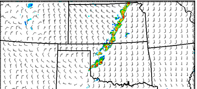
The Texas Tech WRF computer weather model is above. It suggests storm initiation between 4pm and 6pm Friday evening on a line of storms from Nebraska City, Nebraska to Altus, Oklahoma. These storms will press east and norheast into the overnight hours.
From the Storms Prediction Center:
Farther south/southwest…Additional tstm development should occur late friday afternoon and especially into friday evening from eastern ks and northern/western mo into ok near the east-southeastward moving cold front. Some initial supercells will be possible…But squall line development should steadily occur while at least isolated bouts of damaging winds/severe hail continue friday night…But on an increasingly marginal basis overnight/early saturday.
Keep in mind that winds in excess of 60mph and hail to the size of golfballs will be possible with the strongest cells embedded in this line.
For the Wx-Curious
As the area of low pressure ramps up, the main bulk of the severe action will be shifted to the northeast in Minnesota, Iowa and Wisconsin, but places to the south and west in Nebraska, Kansas and Missouri should be prepared for severe storms, too.
The area will have sufficient low-level moisture as well as the upper-level support for severe weather development.
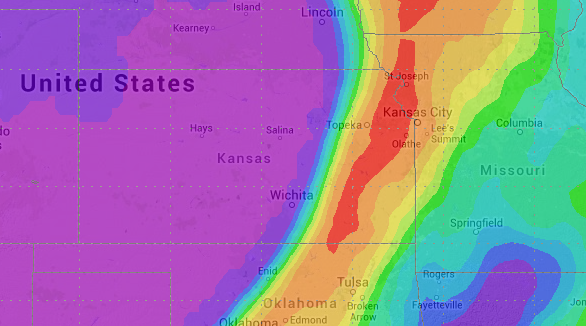
How much low-level moisture? Well, right now soundings suggest dewpoint readings in the 60s and 70s. That will translate, with the help of afternoon heating, to CAPE values well into the 1,000 J/Kg to 2,000 J/Kg range. And in some areas in eastern Kansas up above 3,000 J/Kg.
Often, when investigating the severe weather threat, CAPE values – which is a measure of atmospheric instability – generally need to be about 1,000. When a CAPE value gets above 1,500 J/Kg things are pretty favorable for severe weather development.
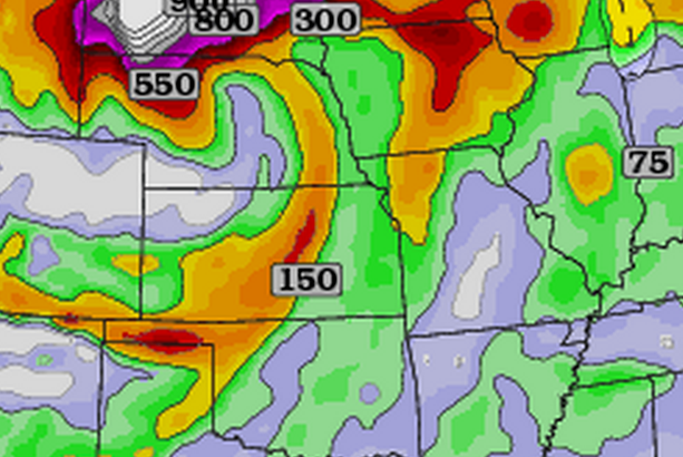
Take a look at the 12z NAM computer weather model 500MB estimation.

At the 500MB level (roughly 18,000ft) there is separation in the isobars – the white lines on the map – that will allow the low-level, moisture-laden air to rise out ahead of the area of low pressure and along the cold front.
As that air rises, it will interact with the other upper-level ingredients that will promote severe weather development.
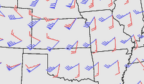
Given the available crossover (the change in wind direction with height) from the surface to 500mb, there is a concern for large hail and damaging winds because as the air gets higher, it will have a tendency to spin with stronger updrafts. The stronger the updraft, the larger the hailstone that can be suspended in the air. Also, keep in mind the stronger the updraft, often the stronger the downdraft on the backside, too.
Speaking of the crossover and the change in wind direction with height – the helicity for Friday is looking “decent” for severe weather.
Right now, the suggested helicity by the NAM computer weather model is modest, and will likely rise in the coming hours as we inch toward Friday afternoon. Readings between 100 and 350 – mainly behind the front – are what is suggested.
Helicity helps determine the possibility of supercell thunderstorms. Right now, this lines up with the current projections that a line of showers and storms will fire across the area while the threat for discrete supercells is minimal.
That said, I still think the threat for a few very isolated supercells will be realized on Friday afternoon/evening before the line of storms congeles and presses east.
Like always, keep an eye to the sky and check back for updates!


