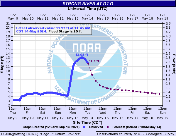
Strong River near D’Lo
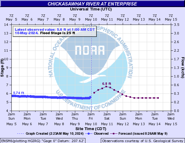
Chickasaway near Enterprise
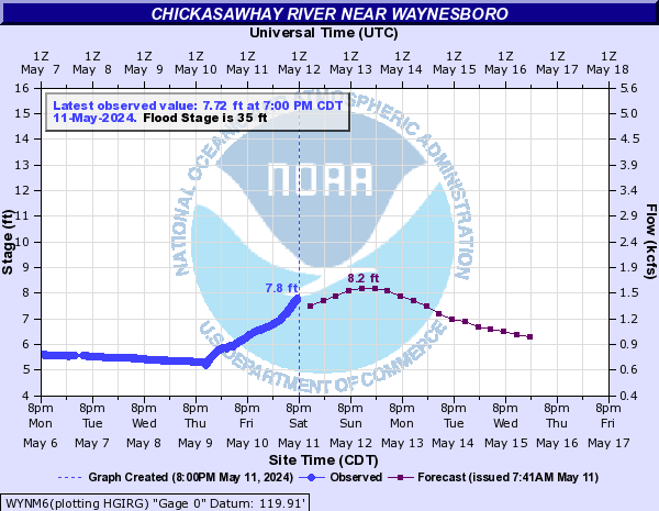
Chickasaway near Waynesboro
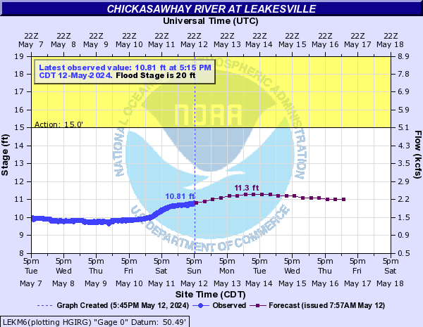
Chickasawhay near Leakesville
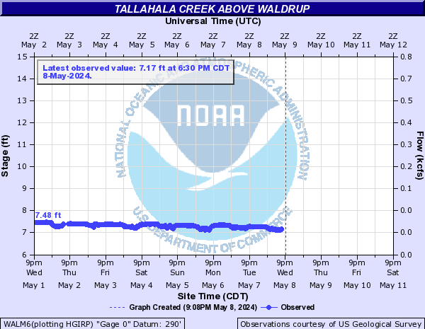
Tallahala Creek above Waldrup
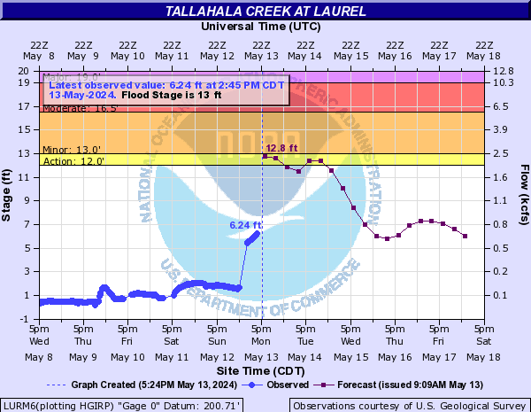
Tallahala Creek near Laurel
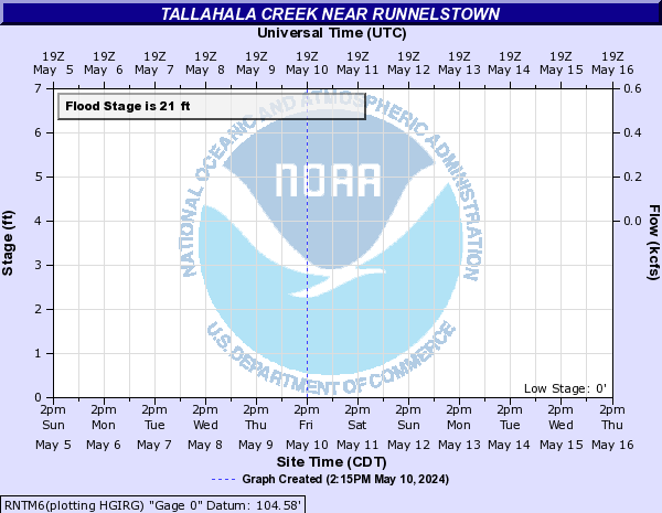
Tallahala Creek near Runnelstown
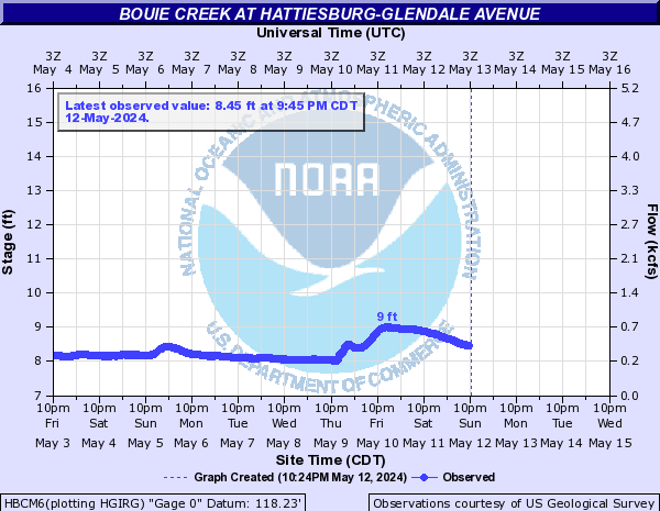
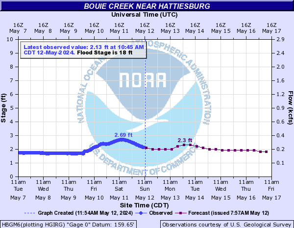
Bouie Creek in Hattiesburg
Bouie Creek near Hattiesburg
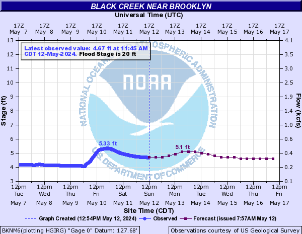
Black Creek near Brooklyn
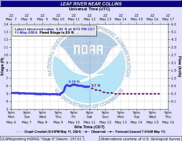
Leaf River near Collins
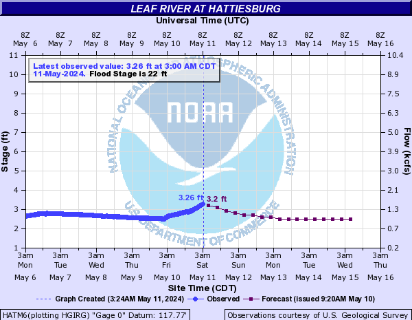
Leaf River near Hattiesburg
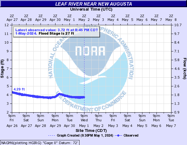
Leaf River near New Augusta
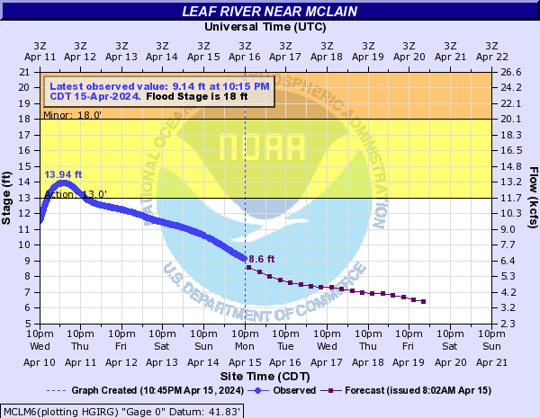
Leaf River near McLain
Pearl River at Jackson

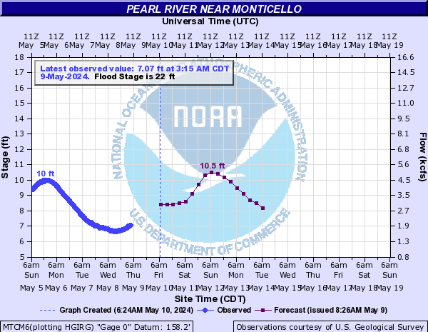
Pearl River near Monticello
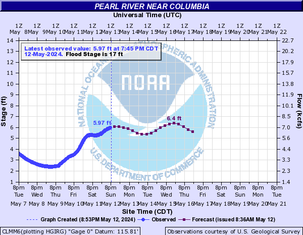
Pearl River near Columbia
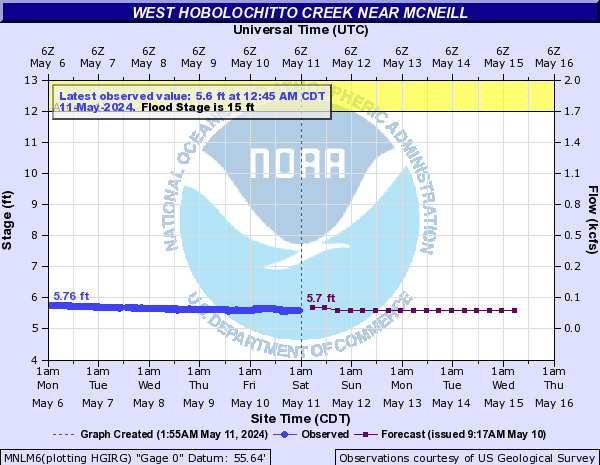
West Hobolochitto Creek near McNeill
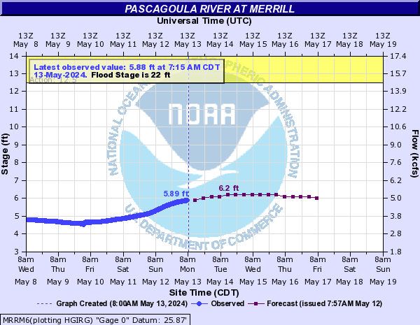
Pascagoula River near Merrill
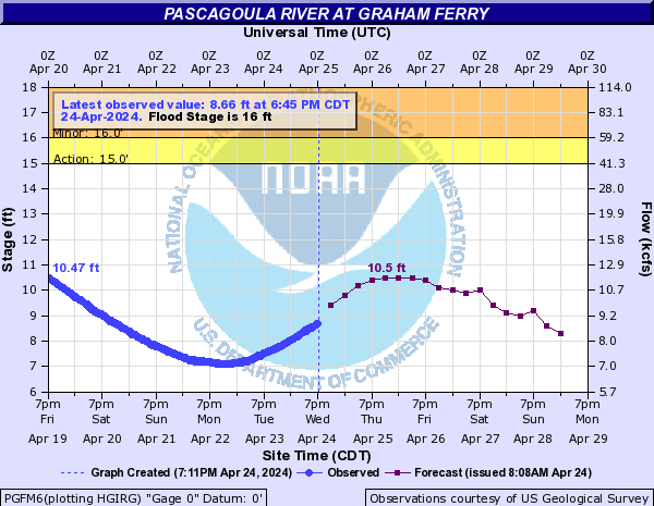
Pascagoula River near Graham Ferry
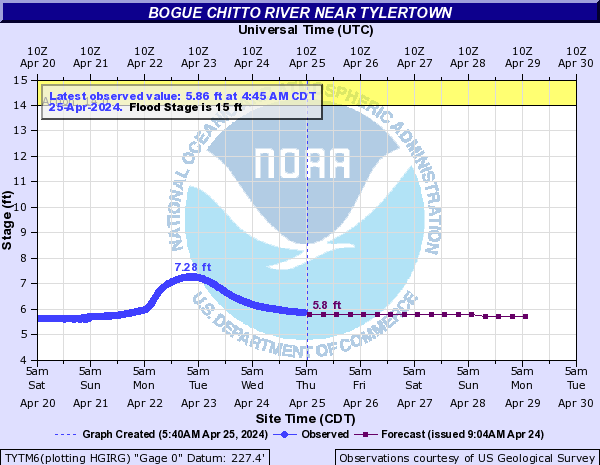
Bogue Chitto River near Tylertown
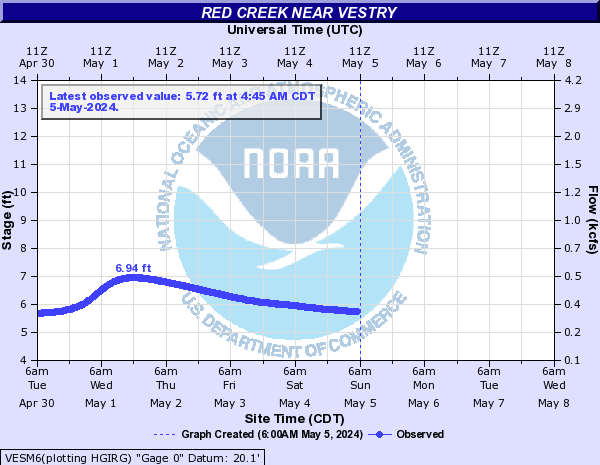
Red Creek near Vestry
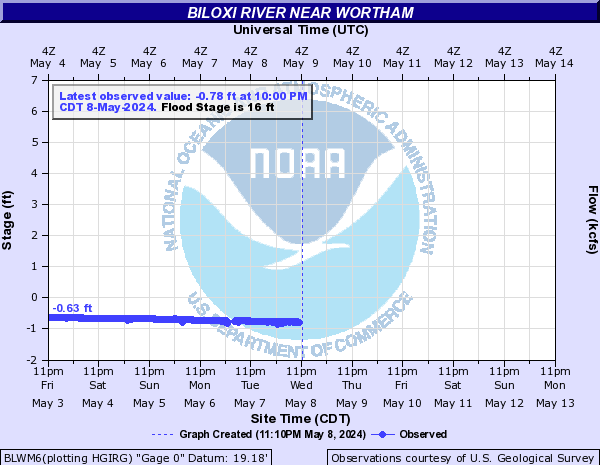
Biloxi River near Wortham
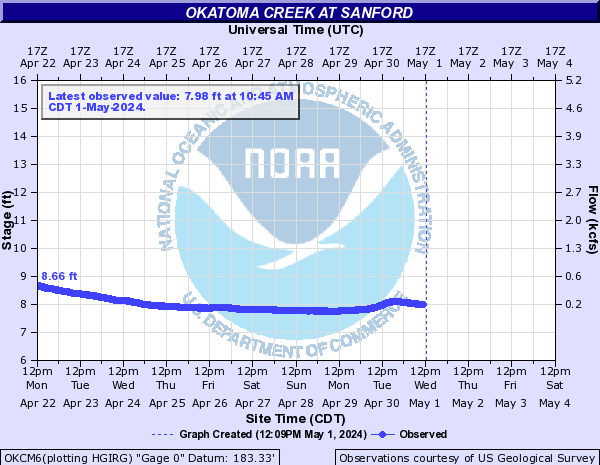
Okatoma near Sanford
Cyprus Creek near Janice

Explaining River Stages
From the River Forecast Center:
NWS High Water Level Terminology
The purpose of this document is to explain the terminology used by the National Weather Service related to high water levels on streams and lakes in Alaska. There are uncountable numbers of streams and lakes of various sizes in Alaska and only a very small fraction of these have gauges that monitor the water levels.
Gauges are devices that allow for the manual or automated monitoring of water level. The term used for the water level of a stream or lake at a gauge is stage.
Stage – the level of the water surface of a river or stream above an established gauge datum at a given location. The gauge datum is a horizontal surface used as a zero point for measurement of water level. This gauge datum level usually is located slightly below the lowest point of the stream bottom such that the stage is greater than the maximum depth of water.
Since gauges are sparse in Alaska, the stage measured at each gauge is used as an index of water level characteristics upstream and downstream of the gauge in addition to the status at the gauge. In many cases, there is only one gauge on a stream system and thus the gauge represents the water level characteristics in the entire stream basin.
The gauge is also often used to indicate the water level status of other streams or lakes in the general area that have similar characteristics to the gauged stream. People living or recreating near any stream or lake should identify the closest gauge that can be used as an index for the expected water level changes at their location.
High water terms used by the National Weather Service include bankfull stage, action stage, and flood stage as defined below. In Alaska, the sparse gauge network requires that these terms be defined with a broader definition that reflects characteristics of the gauged waterbody and well as nearby waterbodies. Thus the definitions consider both the specific impacts that can be documented in the vicinity of the gauge as well as the expected impacts that could result on any waterbody in the general area during an event of that magnitude.
The assignment of these stages thus includes the combined assessment of specific impacts and the frequency of occurrence of the event. The concept of using the frequency of occurrence of high water events to supplement the assessment of flood stages is based on the assumption that frequently occurring water levels such as the 2-year flood (50% chance of occurring in any year) will have few impacts in comparison to the significant impacts expected during an infrequent event such as a 100-year flood (1% chance of occurring in any year).
When high water stages are determined from a flood frequency analysis, the impacts listed for the applicable stages will be the recurrence interval associated with that level and a qualifier to assess the quality of the recurrence interval estimate.
Bankfull Stage – an established gauge height at a given location along a river or stream, above which a rise in water surface will cause the river or stream to overflow the lowest natural stream bank somewhere in the corresponding reach. The term “lowest bank” is however, not intended to apply to an unusually low place or a break in the natural bank through which the water inundates a small area. Bankfull stages on streams with natural or manmade high banks can be defined by the predominant vegetation line on the banks. The bankfull stage on many streams is associated with the 2-year recurrence interval flood. Bankfull stage is not necessarily the same as flood stage.
Action (Near) Stage – the stage which, when reached by a rising stream, represents the level where the NWS or a partner/user needs to take some type of mitigation action in preparation for possible significant hydrologic activity. The type of action taken varies for each gauge location. Gage data should be closely monitored by any affected people if the stage is above action stage.
Flood Stage – an established gauge height for a given location above which a rise in water surface level begins to create a hazard to lives, property, or commerce. The issuance of flood advisories or warnings is linked to flood stage.
Not necessarily the same as bankfull stage. Flood categories are terms defined for each gauge location that describe or categorize the observed or expected severity of flood impacts in the corresponding stream segment or nearby stream. The severity of flooding at a given stage is not necessarily the same at all locations along a stream due to varying channel/bank characteristics on portions of the stream.
Therefore, the stage for a given flood category is usually associated with lowest water level corresponding to the most significant flood impacts somewhere in the reach. The flood categories used in the NWS are minor, moderate, and major flooding, but all three of the flood categories do not necessarily exist for each gage location. Most commonly, gages in remote areas may not have a major flood stage assigned.
Record flooding is flooding that equals or exceeds the highest stage or discharge at a given site during the period of record keeping.
Minor Flooding is defined to have minimal or no property damage, but possibly some public threat.
A FLOOD ADVISORY product is issued to advise the public of flood events that are expected not to exceed the minor flood category.
Examples of conditions that would be considered minor flooding include: water over banks and in yards no building flooded, but some water may be under buildings built on stilts (elevated) personal property in low lying areas needs to be moved or it will get wet water overtopping roads, but not very deep or fast flowing water in campgrounds or on bike paths inconvenience or nuisance flooding small part of the airstrip flooded, and aircraft can still land one or two homes in the lowest parts of town may be cut off or get a little water in the crawl spaces or homes themselves if they are not elevated. In remote areas with few specific impacts, floods with 5-10 year recurrence interval would be assumed to be causing minor flooding on streams in the area.
Moderate Flooding is defined to have some inundation of structures and roads near the stream. Some evacuations of people and/or transfer of property to higher elevations may be necessary.
A FLOOD WARNING should be issued if moderate flooding is expected during the event.
Examples of conditions that would be considered moderate flooding include: several buildings flooded with minor or moderate damage various types of infrastructure rendered temporarily useless (i.e. fuel tanks cannot be reached due to high water, roads flooded that have no alternates, generator station flooded) elders and those living in the lowest parts of the village are evacuated to higher ground access to the airstrip is cut off or requires a boat water over the road is deep enough to make driving unsafe gravel roads likely eroded due to current moving over them widespread flooding, but not deep enough to float ice chunks through town water deep enough to make life difficult, normal life is disrupted and some hardship is endured airstrip closed travel is most likely restricted to boats In remote areas with few specific impacts, floods with 15-40 year recurrence interval would be assumed to be causing moderate flooding on streams in the area.
Major Flooding is defined to have extensive inundation of structures and roads. Significant evacuations of people and/or transfer of property to higher elevations are necessary.
A FLOOD WARNING should be issued if major flooding is expected during the event.
Examples of conditions that would be considered major flooding include: many buildings flooded, some with substantial damage or destruction infrastructure destroyed or rendered useless for an extended period of time multiple homes are flooded or moved off foundations everyone in threatened area is asked to evacuate National Guard units assist in evacuation efforts erosion problems are extreme the airstrip, fuel tanks, and the generator station are likely flooded loss of transportation access, communication, power and/or fuel spills are likely fuel tanks may float and spill and possibly float downstream ice chunks floating though town that could cause structural damage high damage estimates and high degree of danger to residents In remote areas with few specific impacts, floods with 50-100 year recurrence interval would be assumed to be causing major flooding on streams in the area.
Courtesy: lmrfc.noaa.gov

