There is a chance for showers and storms across the area tonight as a cold front kicks through the area. There will be the threat for severe weather, including the risk for brief heavy rain, lightning, wind gusts up to 7-mph, hail up to the size of half dollars, and the potential for a few tornadoes – including tornadoes stronger than EF2.
There will be a Tornado Watch issued tonight.
There will be Tornado Warnings issued tonight.
Severe Weather Ingredients:
- Moisture & Instability: Low-level moisture will increase, leading to 500-1000 J/kg of MLCAPE by mid to late afternoon. However, modest mid-level lapse rates may limit storm intensity.
- Forcing Mechanisms: Strengthening low-level warm advection and strong dynamic lift from the approaching upper trough will trigger thunderstorm development.
- Wind Shear: A 45-55+ kt low-level jet will enhance wind shear, supporting storm organization and rotation.
Expected Evolution:
- Severe Threats Tonight:
- Tornadoes:
- Embedded supercells within the squall line may produce several tornadoes, some of which could be strong, given the enhanced low-level shear.
- Potential for isolated pre-line supercells remains uncertain.
- Damaging Winds:
- Widespread severe-level wind gusts are likely across the area which means large Severe Thunderstorm Warning boxes will be likely from the NWS
- Localized significant wind gusts (>75 mph) may occur where strong mid/low-level flow overlaps with sufficient buoyancy, particularly across the shaded area below (in the middle graphic).
- Tornadoes:


As noted below, the general timeline for storms is generally between 9p and 5a, but it will depend on your location.
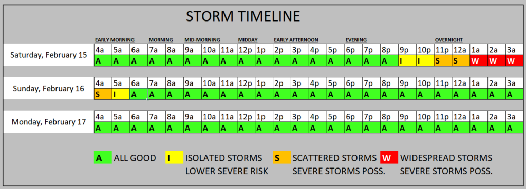
Since we are looking at a single line of storms – with a few isolated cells developing here and there just out ahead of it, this won’t be a wide-window of opportunity at any one given point. Once the storms are nearby, they may only last for about three total hours from the first raindrop to the last raindrop.
But because I cover such a wide area geographically, I have to widen the window since these storms will be moving from west to east. That means if storms start at 9p for you, then they should be done by about midnight. And if rain doesn’t start for you until midnight, it should be done by 3am.
The complicating factor for that timeline forecast will be the instability showers that may develop ahead of the line. These may have a few rumbles of thunder here and there as well as some brief moderate rain. But these are unlikely to pose any kind of severe weather threat.
SOME DATA
I’m not going to go “full bore” digging into the data this morning for a few reasons:
1 – My brain isn’t fully functional yet (only halfway through my morning dose of caffeine)
2 – There is WAY too much for just a single post
3 – I think there is more important stuff to spend my time on for you guys
BUT! I did want to highlight a few things to help contextualize the forecast.
RECENT MODEL TRENDS
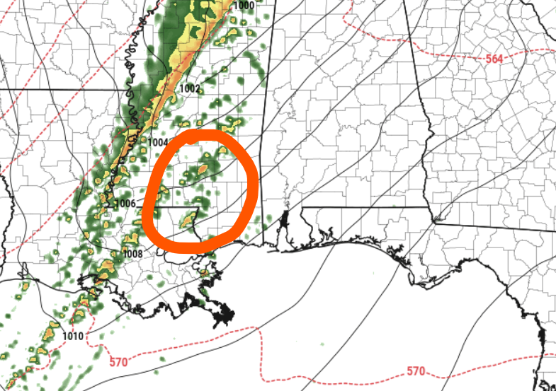
There has been some indication from the higher resolution guidance that the transition to a squall line of storms may not be as quick and storms may develop farther ahead of the line than originally anticipated. This is the latest data from the 13z HRRR model showing storms developing well ahead of the line (the line at the LA/MS border and storms firing out near I-59).
The is a trend during the last handful of runs that has just started to pop up.
There is also a trend that the alignment of the squall line will be more meridional (north-south) and less zonal (west-east). Anecdotally, I’ve found that meridional lines of storms tend to limit the risk for tornadoes embedded within the line to specific points (that we won’t know until the line develops) where there is bowing and apexing, rather than “kinks” developing in the line that foster the development of tornadoes. That may limit the overall number of tornadoes that develop tonight, but we won’t know if that is the case until the line fully develops.
SKEW-Ts
You guys know I love my Skew-Ts. These charts are super helpful for meteorologists to understand what the models think the full atmosphere is looking like at a single point, from top to bottom. We can glean all kinds of good data from these things.
Looking at the averaged data across the warm sector ahead of the front, the near-storm environment is going to be rather ripe for the development of severe weather.

We will have plenty of instability, plenty of shear, plenty of low-level forcing, and even enough ‘umph’ in the downdrafts to scoop up the low-level baroclinicity into a tornado.
Quite literally we can say, “all of the ingredients are there.”
But I think we can pull out some specific details about the risks.
1 – The risk for EF-5 tornadoes is very low.
2 – The risk for baseball-sized hail is very low
3 – There is a chance for some brief spin-up tornadoes where boundaries converge quickly
4 – Many storms will be rotating, not all of those will produce tornadoes
5 – The veer-back-veer signal in the hodograph isn’t as pronounced here, but would bolster support for the risk for strong tornadoes
6 – Peak potential wind gusts should top out at 70mph for our area
7 – General wind will be breezy and gusty, even outside of the storms
UH STREAKS
Speaking of Skew-Ts, I know the other thing that is helpful to meteorologists is the Updraft Helicity Streaks.
This is when we code the computers like, “okay, here is the math to create the strongest storms… tell us where that math all comes together to produce the strongest of the storms.”
And the answer is:
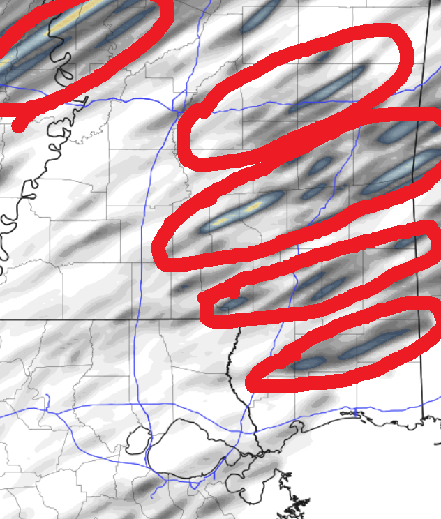
This is just a single map, so don’t get too caught up in the specific placement of those lines. Instead, cehck out the red circles I’ve put on there. Those indicate the average area where the last handful of model runs, across multiple different model suites, suggest the risk for some of the stronger storms.
I know what some of you are thinking: “Nick, that is like the entire area….”
Yeah. It kind of is.
Others of you are thinking, “I live outside of the red circled area, so I am safe! No severe weather for me!”
No. Not quite.
This is where the computer thinks the strongest of the storms may be. Not the only storms. This is a bit of a relative scale on days like today. So we will probably still see some severe storms west of I-55 or down into Louisiana, but the strongest of those storms have been identified across model guidance as being across southern Mississippi.
Does that guarantee tornadoes? No.
Does that guarantee warnings? Also no.
Does it meant he likelihood of those things is much higher? Yes.
TORNADOES LIKE SUNSETS
I mean, who doesn’t, right? But the atmosphere generally likes to produces tornadoes around sunset in our (and many others) area.
Right now, these storms shouldn’t be in our area around sunset. I only point this out because i know some folks may be monitoring storms through the evening as they go about their business.
And if that’s you and you see a big burst of tornadoes between 6p and 8p don’t be alarmed that the level of activity is just going to continue to increase and “oh man, if its that bad over there, and we are in a worse category over here, then it’s going to be way worse over here!”
That isn’t necessarily the case.
Tornadoes just like sunset.
The action should calm down a bit once we get beyond the hour or two after sundown, and then pick back up again once the low-level juet picks back up as we head into the overnight hours. And that is when it will be nearer to our area.
THE BOTTOM LINE
Storms will be possible tonight from around 9 PM to 5 AM, depending on your location. These storms could bring:
– Very heavy rain with the potential for brief, localized flooding
– Frequent lightning
– Wind gusts up to 70 mph
– Hail up to the size of half dollars
– A few tornadoes
How to Stay Safe
Make sure you have multiple ways to receive alerts from the National Weather Service (NWS). Given the strong winds expected, treat both Severe Thunderstorm Warnings and Tornado Warnings similarly. When a warning is issued for your area get to a safe, interior room on the lowest floor of your home or building and hang there until the storms pass.
Should You Stay Up Overnight?
It depends. If you have multiple reliable ways to be alerted—such as a NOAA Weather Radio AND a loud, wake-you-up phone alert like from the NickelBlock Forecast Weather App—you can go to bed. If not, consider staying up or sleeping in a central room with the TV on so you can quickly access storm information.
What About Mobile Homes?
This also depends. Properly anchored and fortified mobile homes can mostly withstand EF-0 and EF-1 tornadoes. Without such provisions they cannot. And we may have a few of those. On top of that, we may also see EF-2 and stronger tornadoes. And those can cause significant damage to all types of buildings – but more specifically to all types of mobile homes. If a Tornado Warning is issued and storms are approaching, consider having a sturdier shelter option in mind ahead of time.
Hang in there, friends. We will get through this round of weather by tomorrow morning and then we will be talking about cooler temperatures trying to push into the area.


