Here is a look, county-by-county, at the forecast for tonight. I tried my best to breakdown the timeline and threats. In this case, a lot of the threats are pretty similar spot-to-spot, so there is goingt o be more overlap than normal.
Here is the general storm timeline:
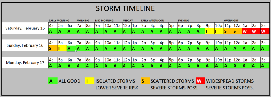
A more specific timeline by county is below….
COUNTY-BY-COUNTY FORECAST
I-20 CORRIDOR
HINDS COUNTY
A line of storms is set to move through the area later tonight. This line may produce severe weather.
Everyone should expect:
✅ Brief heavy rain
✅ Frequent lightning
✅ Wind gusts up to 40 mph
🔴 Some areas may see hail
🔴 A few areas could also see a tornado
7 PM – 9 PM: Showers and storms possible. Main concerns: brief heavy rain, lightning, and wind gusts up to 45 mph. Severe weather is less likely but cannot be ruled out.
9 PM – 12 AM: Severe storms likely. Main concerns: heavy rain, frequent lightning, wind gusts up to 70 mph, hail up to the size of half dollars, and a few tornadoes (up to EF-4 strength).
12 AM – 2 AM: Storms ending. Severe weather less likely.
🟡 A Tornado Watch from the NWS is likely
🟡 Storm-related warnings from the NWS are likely
⚠️ Brief, localized flash flooding possible
🌳 Downed trees possible
🚧 Roads may become impassable for a short time
⚡ Power outages possible (lasting up to 6 hours)
COPIAH COUNTY
A line of storms is set to move through the area later tonight. This line may produce severe weather.
Everyone should expect:
✅ Brief heavy rain
✅ Frequent lightning
✅ Wind gusts up to 40 mph
🔴 Some areas may see hail
🔴 A few areas could also see a tornado
7 PM – 9 PM: Showers and storms possible. Main concerns: brief heavy rain, lightning, and wind gusts up to 45 mph. Severe weather is less likely but cannot be ruled out.
9 PM – 12 AM: Severe storms likely. Main concerns: heavy rain, frequent lightning, wind gusts up to 70 mph, hail up to the size of half dollars, and a few tornadoes (up to EF-4 strength).
12 AM – 2 AM: Storms ending. Severe weather less likely.
🟡 A Tornado Watch from the NWS is likely
🟡 Storm-related warnings from the NWS are likely
⚠️ Brief, localized flash flooding possible
🌳 Downed trees possible
🚧 Roads may become impassable for a short time
⚡ Power outages possible (lasting up to 6 hours)
RANKIN COUNTY
A line of storms is set to move through the area later tonight. This line may produce severe weather.
Everyone should expect:
✅ Brief heavy rain
✅ Frequent lightning
✅ Wind gusts up to 40 mph
🔴 Some areas may see hail
🔴 A few areas could also see a tornado
7 PM – 9 PM: Showers and storms possible. Main concerns: brief heavy rain, lightning, and wind gusts up to 45 mph. Severe weather is less likely but cannot be ruled out.
9 PM – 12 AM: Severe storms likely. Main concerns: heavy rain, frequent lightning, wind gusts up to 70 mph, hail up to the size of half dollars, and a few tornadoes (up to EF-4 strength).
12 AM – 3 AM: Storms ending. Severe weather less likely.
🟡 A Tornado Watch from the NWS is likely
🟡 Storm-related warnings from the NWS are likely
⚠️ Brief, localized flash flooding possible
🌳 Downed trees possible
🚧 Roads may become impassable for a short time
⚡ Power outages possible (lasting up to 6 hours)
SIMPSON COUNTY
A line of storms is set to move through the area later tonight. This line may produce severe weather.
Everyone should expect:
✅ Brief heavy rain
✅ Frequent lightning
✅ Wind gusts up to 40 mph
🔴 Some areas may see hail
🔴 A few areas could also see a tornado
7 PM – 9 PM: Showers and storms possible. Main concerns: brief heavy rain, lightning, and wind gusts up to 45 mph. Severe weather is less likely but cannot be ruled out.
9 PM – 12 AM: Severe storms likely. Main concerns: heavy rain, frequent lightning, wind gusts up to 70 mph, hail up to the size of half dollars, and a few tornadoes (up to EF-4 strength).
12 AM – 3 AM: Storms ending. Severe weather less likely.
🟡 A Tornado Watch from the NWS is likely
🟡 Storm-related warnings from the NWS are likely
⚠️ Brief, localized flash flooding possible
🌳 Downed trees possible
🚧 Roads may become impassable for a short time
⚡ Power outages possible (lasting up to 6 hours)
SCOTT COUNTY
A line of storms is set to move through the area later tonight. This line may produce severe weather.
Everyone should expect:
✅ Brief heavy rain
✅ Frequent lightning
✅ Wind gusts up to 40 mph
🔴 Some areas may see hail
🔴 A few areas could also see a tornado
8 PM – 10 PM: Showers and storms possible. Main concerns: brief heavy rain, lightning, and wind gusts up to 45 mph. Severe weather is less likely but cannot be ruled out.
10 PM – 1 AM: Severe storms likely. Main concerns: heavy rain, frequent lightning, wind gusts up to 70 mph, hail up to the size of half dollars, and a few tornadoes (up to EF-3 strength).
1 AM – 4 AM: Storms ending. Severe weather less likely.
🟡 A Tornado Watch from the NWS is likely
🟡 Storm-related warnings from the NWS are likely
⚠️ Brief, localized flash flooding possible
🌳 Downed trees possible
🚧 Roads may become impassable for a short time
⚡ Power outages possible (lasting up to 6 hours)
SMITH COUNTY
A line of storms is set to move through the area later tonight. This line may produce severe weather.
Everyone should expect:
✅ Brief heavy rain
✅ Frequent lightning
✅ Wind gusts up to 40 mph
🔴 Some areas may see hail
🔴 A few areas could also see a tornado
8 PM – 10 PM: Showers and storms possible. Main concerns: brief heavy rain, lightning, and wind gusts up to 45 mph. Severe weather is less likely but cannot be ruled out.
10 PM – 1 AM: Severe storms likely. Main concerns: heavy rain, frequent lightning, wind gusts up to 70 mph, hail up to the size of half dollars, and a few tornadoes (up to EF-3 strength).
1 AM – 4 AM: Storms ending. Severe weather less likely.
🟡 A Tornado Watch from the NWS is likely
🟡 Storm-related warnings from the NWS are likely
⚠️ Brief, localized flash flooding possible
🌳 Downed trees possible
🚧 Roads may become impassable for a short time
⚡ Power outages possible (lasting up to 6 hours)
NEWTON COUNTY
A line of storms is set to move through the area later tonight. This line may produce severe weather.
Everyone should expect:
✅ Brief heavy rain
✅ Frequent lightning
✅ Wind gusts up to 40 mph
🔴 Some areas may see hail
🔴 A few areas could also see a tornado
9 PM – 11 PM: Showers and storms possible. Main concerns: brief heavy rain, lightning, and wind gusts up to 45 mph. Severe weather is less likely but cannot be ruled out.
11 PM – 2 AM: Severe storms likely. Main concerns: heavy rain, frequent lightning, wind gusts up to 70 mph, hail up to the size of half dollars, and a few tornadoes (up to EF-3 strength).
2 AM – 4 AM: Storms ending. Severe weather less likely.
🟡 A Tornado Watch from the NWS is likely
🟡 Storm-related warnings from the NWS are likely
⚠️ Brief, localized flash flooding possible
🌳 Downed trees possible
🚧 Roads may become impassable for a short time
⚡ Power outages possible (lasting up to 6 hours)
JASPER COUNTY
A line of storms is set to move through the area later tonight. This line may produce severe weather.
Everyone should expect:
✅ Brief heavy rain
✅ Frequent lightning
✅ Wind gusts up to 40 mph
🔴 Some areas may see hail
🔴 A few areas could also see a tornado
9 PM – 11 PM: Showers and storms possible. Main concerns: brief heavy rain, lightning, and wind gusts up to 45 mph. Severe weather is less likely but cannot be ruled out.
11 PM – 2 AM: Severe storms likely. Main concerns: heavy rain, frequent lightning, wind gusts up to 70 mph, hail up to the size of half dollars, and a few tornadoes (up to EF-3 strength).
2 AM – 4 AM: Storms ending. Severe weather less likely.
🟡 A Tornado Watch from the NWS is likely
🟡 Storm-related warnings from the NWS are likely
⚠️ Brief, localized flash flooding possible
🌳 Downed trees possible
🚧 Roads may become impassable for a short time
⚡ Power outages possible (lasting up to 6 hours)
LAUDERDALE COUNTY
A line of storms is set to move through the area later tonight. This line may produce severe weather.
Everyone should expect:
✅ Brief heavy rain
✅ Frequent lightning
✅ Wind gusts up to 40 mph
🔴 Some areas may see hail
🔴 A few areas could also see a tornado
9 PM – 11 PM: Showers and storms possible. Main concerns: brief heavy rain, lightning, and wind gusts up to 45 mph. Severe weather is less likely but cannot be ruled out.
11 PM – 2 AM: Severe storms likely. Main concerns: heavy rain, frequent lightning, wind gusts up to 70 mph, hail up to the size of half dollars, and a few tornadoes (up to EF-3 strength).
2 AM – 4 AM: Storms ending. Severe weather less likely.
🟡 A Tornado Watch from the NWS is likely
🟡 Storm-related warnings from the NWS are likely
⚠️ Brief, localized flash flooding possible
🌳 Downed trees possible
🚧 Roads may become impassable for a short time
⚡ Power outages possible (lasting up to 6 hours)
CLARKE COUNTY
A line of storms is set to move through the area later tonight. This line may produce severe weather.
Everyone should expect:
✅ Brief heavy rain
✅ Frequent lightning
✅ Wind gusts up to 40 mph
🔴 Some areas may see hail
🔴 A few areas could also see a tornado
9 PM – 11 PM: Showers and storms possible. Main concerns: brief heavy rain, lightning, and wind gusts up to 45 mph. Severe weather is less likely but cannot be ruled out.
11 PM – 2 AM: Severe storms likely. Main concerns: heavy rain, frequent lightning, wind gusts up to 70 mph, hail up to the size of half dollars, and a few tornadoes (up to EF-3 strength).
2 AM – 4 AM: Storms ending. Severe weather less likely.
🟡 A Tornado Watch from the NWS is likely
🟡 Storm-related warnings from the NWS are likely
⚠️ Brief, localized flash flooding possible
🌳 Downed trees possible
🚧 Roads may become impassable for a short time
⚡ Power outages possible (lasting up to 6 hours)
HWY 84 CORRIDOR
LINCOLN COUNTY
A line of storms is set to move through the area later tonight. This line may produce severe weather.
Everyone should expect:
✅ Brief heavy rain
✅ Frequent lightning
✅ Wind gusts up to 40 mph
🔴 Some areas may see hail
🔴 A few areas could also see a tornado
7 PM – 9 PM: Showers and storms possible. Main concerns: brief heavy rain, lightning, and wind gusts up to 45 mph. Severe weather is less likely but cannot be ruled out.
9 PM – 12 AM: Severe storms likely. Main concerns: heavy rain, frequent lightning, wind gusts up to 70 mph, hail up to the size of half dollars, and a few tornadoes (up to EF-3 strength).
12 AM – 2 AM: Storms ending. Severe weather less likely.
🟡 A Tornado Watch from the NWS is likely
🟡 Storm-related warnings from the NWS are likely
⚠️ Brief, localized flash flooding possible
🌳 Downed trees possible
🚧 Roads may become impassable for a short time
⚡ Power outages possible (lasting up to 6 hours)
LAWRENCE COUNTY
A line of storms is set to move through the area later tonight. This line may produce severe weather.
Everyone should expect:
✅ Brief heavy rain
✅ Frequent lightning
✅ Wind gusts up to 40 mph
🔴 Some areas may see hail
🔴 A few areas could also see a tornado
8 PM – 10 PM: Showers and storms possible. Main concerns: brief heavy rain, lightning, and wind gusts up to 45 mph. Severe weather is less likely but cannot be ruled out.
10 PM – 1 AM: Severe storms likely. Main concerns: heavy rain, frequent lightning, wind gusts up to 70 mph, hail up to the size of half dollars, and a few tornadoes (up to EF-3 strength).
1 AM – 4 AM: Storms ending. Severe weather less likely.
🟡 A Tornado Watch from the NWS is likely
🟡 Storm-related warnings from the NWS are likely
⚠️ Brief, localized flash flooding possible
🌳 Downed trees possible
🚧 Roads may become impassable for a short time
⚡ Power outages possible (lasting up to 6 hours)
JEFF DAVIS COUNTY
A line of storms is set to move through the area later tonight. This line may produce severe weather.
Everyone should expect:
✅ Brief heavy rain
✅ Frequent lightning
✅ Wind gusts up to 40 mph
🔴 Some areas may see hail
🔴 A few areas could also see a tornado
8 PM – 10 PM: Showers and storms possible. Main concerns: brief heavy rain, lightning, and wind gusts up to 45 mph. Severe weather is less likely but cannot be ruled out.
10 PM – 1 AM: Severe storms likely. Main concerns: heavy rain, frequent lightning, wind gusts up to 70 mph, hail up to the size of half dollars, and a few tornadoes (up to EF-3 strength).
1 AM – 4 AM: Storms ending. Severe weather less likely.
🟡 A Tornado Watch from the NWS is likely
🟡 Storm-related warnings from the NWS are likely
⚠️ Brief, localized flash flooding possible
🌳 Downed trees possible
🚧 Roads may become impassable for a short time
⚡ Power outages possible (lasting up to 6 hours)
COVINGTON COUNTY
A line of storms is set to move through the area later tonight. This line may produce severe weather.
Everyone should expect:
✅ Brief heavy rain
✅ Frequent lightning
✅ Wind gusts up to 40 mph
🔴 Some areas may see hail
🔴 A few areas could also see a tornado
9 PM – 11 PM: Showers and storms possible. Main concerns: brief heavy rain, lightning, and wind gusts up to 45 mph. Severe weather is less likely but cannot be ruled out.
11 PM – 2 AM: Severe storms likely. Main concerns: heavy rain, frequent lightning, wind gusts up to 70 mph, hail up to the size of half dollars, and a few tornadoes (up to EF-3 strength).
2 AM – 4 AM: Storms ending. Severe weather less likely.
🟡 A Tornado Watch from the NWS is likely
🟡 Storm-related warnings from the NWS are likely
⚠️ Brief, localized flash flooding possible
🌳 Downed trees possible
🚧 Roads may become impassable for a short time
⚡ Power outages possible (lasting up to 6 hours)
JONES COUNTY
A line of storms is set to move through the area later tonight. This line may produce severe weather.
Everyone should expect:
✅ Brief heavy rain
✅ Frequent lightning
✅ Wind gusts up to 40 mph
🔴 Some areas may see hail
🔴 A few areas could also see a tornado
9 PM – 11 PM: Showers and storms possible. Main concerns: brief heavy rain, lightning, and wind gusts up to 45 mph. Severe weather is less likely but cannot be ruled out.
11 PM – 2 AM: Severe storms likely. Main concerns: heavy rain, frequent lightning, wind gusts up to 70 mph, hail up to the size of half dollars, and a few tornadoes (up to EF-3 strength).
2 AM – 4 AM: Storms ending. Severe weather less likely.
🟡 A Tornado Watch from the NWS is likely
🟡 Storm-related warnings from the NWS are likely
⚠️ Brief, localized flash flooding possible
🌳 Downed trees possible
🚧 Roads may become impassable for a short time
⚡ Power outages possible (lasting up to 6 hours)
WAYNE COUNTY
A line of storms is set to move through the area later tonight. This line may produce severe weather.
Everyone should expect:
✅ Brief heavy rain
✅ Frequent lightning
✅ Wind gusts up to 40 mph
🔴 Some areas may see hail
🔴 A few areas could also see a tornado
9 PM – 11 PM: Showers and storms possible. Main concerns: brief heavy rain, lightning, and wind gusts up to 45 mph. Severe weather is less likely but cannot be ruled out.
11 PM – 2 AM: Severe storms likely. Main concerns: heavy rain, frequent lightning, wind gusts up to 70 mph, hail up to the size of half dollars, and a few tornadoes (up to EF-3 strength).
2 AM – 4 AM: Storms ending. Severe weather less likely.
🟡 A Tornado Watch from the NWS is likely
🟡 Storm-related warnings from the NWS are likely
⚠️ Brief, localized flash flooding possible
🌳 Downed trees possible
🚧 Roads may become impassable for a short time
⚡ Power outages possible (lasting up to 6 hours)
HWY 98 CORRIDOR
PIKE COUNTY
A line of storms is set to move through the area later tonight. This line may produce severe weather.
Everyone should expect:
✅ Brief heavy rain
✅ Frequent lightning
✅ Wind gusts up to 40 mph
🔴 Some areas may see hail
🔴 A few areas could also see a tornado
8 PM – 10 PM: Showers and storms possible. Main concerns: brief heavy rain, lightning, and wind gusts up to 45 mph. Severe weather is less likely but cannot be ruled out.
10 PM – 1 AM: Severe storms likely. Main concerns: heavy rain, frequent lightning, wind gusts up to 70 mph, hail up to the size of half dollars, and a few tornadoes (up to EF-3 strength).
1 AM – 4 AM: Storms ending. Severe weather less likely.
🟡 A Tornado Watch from the NWS is likely
🟡 Storm-related warnings from the NWS are likely
⚠️ Brief, localized flash flooding possible
🌳 Downed trees possible
🚧 Roads may become impassable for a short time
⚡ Power outages possible (lasting up to 6 hours)
WALTHALL COUNTY
A line of storms is set to move through the area later tonight. This line may produce severe weather.
Everyone should expect:
✅ Brief heavy rain
✅ Frequent lightning
✅ Wind gusts up to 40 mph
🔴 Some areas may see hail
🔴 A few areas could also see a tornado
8 PM – 10 PM: Showers and storms possible. Main concerns: brief heavy rain, lightning, and wind gusts up to 45 mph. Severe weather is less likely but cannot be ruled out.
10 PM – 1 AM: Severe storms likely. Main concerns: heavy rain, frequent lightning, wind gusts up to 70 mph, hail up to the size of half dollars, and a few tornadoes (up to EF-3 strength).
1 AM – 4 AM: Storms ending. Severe weather less likely.
🟡 A Tornado Watch from the NWS is likely
🟡 Storm-related warnings from the NWS are likely
⚠️ Brief, localized flash flooding possible
🌳 Downed trees possible
🚧 Roads may become impassable for a short time
⚡ Power outages possible (lasting up to 6 hours)
MARION COUNTY
A line of storms is set to move through the area later tonight. This line may produce severe weather.
Everyone should expect:
✅ Brief heavy rain
✅ Frequent lightning
✅ Wind gusts up to 40 mph
🔴 Some areas may see hail
🔴 A few areas could also see a tornado
9 PM – 11 PM: Showers and storms possible. Main concerns: brief heavy rain, lightning, and wind gusts up to 45 mph. Severe weather is less likely but cannot be ruled out.
11 PM – 2 AM: Severe storms likely. Main concerns: heavy rain, frequent lightning, wind gusts up to 70 mph, hail up to the size of half dollars, and a few tornadoes (up to EF-3 strength).
2 AM – 4 AM: Storms ending. Severe weather less likely.
🟡 A Tornado Watch from the NWS is likely
🟡 Storm-related warnings from the NWS are likely
⚠️ Brief, localized flash flooding possible
🌳 Downed trees possible
🚧 Roads may become impassable for a short time
⚡ Power outages possible (lasting up to 6 hours)
LAMAR COUNTY
A line of storms is set to move through the area later tonight. This line may produce severe weather.
Everyone should expect:
✅ Brief heavy rain
✅ Frequent lightning
✅ Wind gusts up to 40 mph
🔴 Some areas may see hail
🔴 A few areas could also see a tornado
9 PM – 11 PM: Showers and storms possible. Main concerns: brief heavy rain, lightning, and wind gusts up to 45 mph. Severe weather is less likely but cannot be ruled out.
11 PM – 2 AM: Severe storms likely. Main concerns: heavy rain, frequent lightning, wind gusts up to 70 mph, hail up to the size of half dollars, and a few tornadoes (up to EF-3 strength).
2 AM – 4 AM: Storms ending. Severe weather less likely.
🟡 A Tornado Watch from the NWS is likely
🟡 Storm-related warnings from the NWS are likely
⚠️ Brief, localized flash flooding possible
🌳 Downed trees possible
🚧 Roads may become impassable for a short time
⚡ Power outages possible (lasting up to 6 hours)
FORREST COUNTY
A line of storms is set to move through the area later tonight. This line may produce severe weather.
Everyone should expect:
✅ Brief heavy rain
✅ Frequent lightning
✅ Wind gusts up to 40 mph
🔴 Some areas may see hail
🔴 A few areas could also see a tornado
10 PM – 12 AM: Showers and storms possible. Main concerns: brief heavy rain, lightning, and wind gusts up to 45 mph. Severe weather is less likely but cannot be ruled out.
12 AM – 3 AM: Severe storms likely. Main concerns: heavy rain, frequent lightning, wind gusts up to 70 mph, hail up to the size of half dollars, and a few tornadoes (up to EF-3 strength).
3 AM – 5 AM: Storms ending. Severe weather less likely.
🟡 A Tornado Watch from the NWS is likely
🟡 Storm-related warnings from the NWS are likely
⚠️ Brief, localized flash flooding possible
🌳 Downed trees possible
🚧 Roads may become impassable for a short time
⚡ Power outages possible (lasting up to 6 hours)
PERRY COUNTY
A line of storms is set to move through the area later tonight. This line may produce severe weather.
Everyone should expect:
✅ Brief heavy rain
✅ Frequent lightning
✅ Wind gusts up to 40 mph
🔴 Some areas may see hail
🔴 A few areas could also see a tornado
10 PM – 12 AM: Showers and storms possible. Main concerns: brief heavy rain, lightning, and wind gusts up to 45 mph. Severe weather is less likely but cannot be ruled out.
12 AM – 3 AM: Severe storms likely. Main concerns: heavy rain, frequent lightning, wind gusts up to 70 mph, hail up to the size of half dollars, and a few tornadoes (up to EF-3 strength).
3 AM – 5 AM: Storms ending. Severe weather less likely.
🟡 A Tornado Watch from the NWS is likely
🟡 Storm-related warnings from the NWS are likely
⚠️ Brief, localized flash flooding possible
🌳 Downed trees possible
🚧 Roads may become impassable for a short time
⚡ Power outages possible (lasting up to 6 hours)
GREENE COUNTY
A line of storms is set to move through the area later tonight. This line may produce severe weather.
Everyone should expect:
✅ Brief heavy rain
✅ Frequent lightning
✅ Wind gusts up to 40 mph
🔴 Some areas may see hail
🔴 A few areas could also see a tornado
11 PM – 1 AM: Showers and storms possible. Main concerns: brief heavy rain, lightning, and wind gusts up to 45 mph. Severe weather is less likely but cannot be ruled out.
1 AM – 4 AM: Severe storms likely. Main concerns: heavy rain, frequent lightning, wind gusts up to 70 mph, hail up to the size of half dollars, and a few tornadoes (up to EF-3 strength).
4 AM – 6 AM: Storms ending. Severe weather less likely.
🟡 A Tornado Watch from the NWS is likely
🟡 Storm-related warnings from the NWS are likely
⚠️ Brief, localized flash flooding possible
🌳 Downed trees possible
🚧 Roads may become impassable for a short time
⚡ Power outages possible (lasting up to 6 hours)
HWY 26 CORRIDOR
PEARL RIVER COUNTY
A line of storms is set to move through the area later tonight. This line may produce severe weather.
Everyone should expect:
✅ Brief heavy rain
✅ Frequent lightning
✅ Wind gusts up to 40 mph
🔴 Some areas may see hail
🔴 A few areas could also see a tornado
9 PM – 11 PM: Showers and storms possible. Main concerns: brief heavy rain, lightning, and wind gusts up to 45 mph. Severe weather is less likely but cannot be ruled out.
11 PM – 2 AM: Severe storms likely. Main concerns: heavy rain, frequent lightning, wind gusts up to 70 mph, hail up to the size of half dollars, and a few tornadoes (up to EF-3 strength).
2 AM – 4 AM: Storms ending. Severe weather less likely.
🟡 A Tornado Watch from the NWS is likely
🟡 Storm-related warnings from the NWS are likely
⚠️ Brief, localized flash flooding possible
🌳 Downed trees possible
🚧 Roads may become impassable for a short time
⚡ Power outages possible (lasting up to 6 hours)
STONE COUNTY
A line of storms is set to move through the area later tonight. This line may produce severe weather.
Everyone should expect:
✅ Brief heavy rain
✅ Frequent lightning
✅ Wind gusts up to 40 mph
🔴 Some areas may see hail
🔴 A few areas could also see a tornado
10 PM – 12 AM: Showers and storms possible. Main concerns: brief heavy rain, lightning, and wind gusts up to 45 mph. Severe weather is less likely but cannot be ruled out.
12 AM – 3 AM: Severe storms likely. Main concerns: heavy rain, frequent lightning, wind gusts up to 70 mph, hail up to the size of half dollars, and a few tornadoes (up to EF-3 strength).
3 AM – 5 AM: Storms ending. Severe weather less likely.
🟡 A Tornado Watch from the NWS is likely
🟡 Storm-related warnings from the NWS are likely
⚠️ Brief, localized flash flooding possible
🌳 Downed trees possible
🚧 Roads may become impassable for a short time
⚡ Power outages possible (lasting up to 6 hours)
GEORGE COUNTY
A line of storms is set to move through the area later tonight. This line may produce severe weather.
Everyone should expect:
✅ Brief heavy rain
✅ Frequent lightning
✅ Wind gusts up to 40 mph
🔴 Some areas may see hail
🔴 A few areas could also see a tornado
10 PM – 12 AM: Showers and storms possible. Main concerns: brief heavy rain, lightning, and wind gusts up to 45 mph. Severe weather is less likely but cannot be ruled out.
12 AM – 3 AM: Severe storms likely. Main concerns: heavy rain, frequent lightning, wind gusts up to 70 mph, hail up to the size of half dollars, and a few tornadoes (up to EF-3 strength).
3 AM – 5 AM: Storms ending. Severe weather less likely.
🟡 A Tornado Watch from the NWS is likely
🟡 Storm-related warnings from the NWS are likely
⚠️ Brief, localized flash flooding possible
🌳 Downed trees possible
🚧 Roads may become impassable for a short time
⚡ Power outages possible (lasting up to 6 hours)
COASTAL COUNTIES
HANCOCK COUNTY
A line of storms is set to move through the area later tonight. This line may produce severe weather.
Everyone should expect:
✅ Brief heavy rain
✅ Frequent lightning
✅ Wind gusts up to 40 mph
🔴 Some areas may see hail
🔴 A few areas could also see a tornado
9 PM – 11 PM: Showers and storms possible. Main concerns: brief heavy rain, lightning, and wind gusts up to 45 mph. Severe weather is less likely but cannot be ruled out.
11 PM – 2 AM: Severe storms likely. Main concerns: heavy rain, frequent lightning, wind gusts up to 70 mph, hail up to the size of half dollars, and a few tornadoes (up to EF-3 strength).
2 AM – 4 AM: Storms ending. Severe weather less likely.
🟡 A Tornado Watch from the NWS is likely
🟡 Storm-related warnings from the NWS are likely
⚠️ Brief, localized flash flooding possible
🌳 Downed trees possible
🚧 Roads may become impassable for a short time
⚡ Power outages possible (lasting up to 6 hours)
HARRISON COUNTY
A line of storms is set to move through the area later tonight. This line may produce severe weather.
Everyone should expect:
✅ Brief heavy rain
✅ Frequent lightning
✅ Wind gusts up to 40 mph
🔴 Some areas may see hail
🔴 A few areas could also see a tornado
10 PM – 12 AM: Showers and storms possible. Main concerns: brief heavy rain, lightning, and wind gusts up to 45 mph. Severe weather is less likely but cannot be ruled out.
12 AM – 3 AM: Severe storms likely. Main concerns: heavy rain, frequent lightning, wind gusts up to 70 mph, hail up to the size of half dollars, and a few tornadoes (up to EF-3 strength).
3 AM – 5 AM: Storms ending. Severe weather less likely.
🟡 A Tornado Watch from the NWS is likely
🟡 Storm-related warnings from the NWS are likely
⚠️ Brief, localized flash flooding possible
🌳 Downed trees possible
🚧 Roads may become impassable for a short time
⚡ Power outages possible (lasting up to 6 hours)
JACKSON COUNTY
A line of storms is set to move through the area later tonight. This line may produce severe weather.
Everyone should expect:
✅ Brief heavy rain
✅ Frequent lightning
✅ Wind gusts up to 40 mph
🔴 Some areas may see hail
🔴 A few areas could also see a tornado
10 PM – 12 AM: Showers and storms possible. Main concerns: brief heavy rain, lightning, and wind gusts up to 45 mph. Severe weather is less likely but cannot be ruled out.
12 AM – 3 AM: Severe storms likely. Main concerns: heavy rain, frequent lightning, wind gusts up to 70 mph, hail up to the size of half dollars, and a few tornadoes (up to EF-3 strength).
3 AM – 5 AM: Storms ending. Severe weather less likely.
🟡 A Tornado Watch from the NWS is likely
🟡 Storm-related warnings from the NWS are likely
⚠️ Brief, localized flash flooding possible
🌳 Downed trees possible
🚧 Roads may become impassable for a short time
⚡ Power outages possible (lasting up to 6 hours)
LOUISIANA PARISHES
TANGIPAHOA PARISH
A line of storms is set to move through the area later tonight. This line may produce severe weather.
Everyone should expect:
✅ Brief heavy rain
✅ Frequent lightning
✅ Wind gusts up to 40 mph
🔴 Some areas may see hail
🔴 A few areas could also see a tornado
8 PM – 10 PM: Showers and storms possible. Main concerns: brief heavy rain, lightning, and wind gusts up to 45 mph. Severe weather is less likely but cannot be ruled out.
10 PM – 1 AM: Severe storms likely. Main concerns: heavy rain, frequent lightning, wind gusts up to 70 mph, hail up to the size of half dollars, and a few tornadoes (up to EF-3 strength).
1 AM – 4 AM: Storms ending. Severe weather less likely.
🟡 A Tornado Watch from the NWS is likely
🟡 Storm-related warnings from the NWS are likely
⚠️ Brief, localized flash flooding possible
🌳 Downed trees possible
🚧 Roads may become impassable for a short time
⚡ Power outages possible (lasting up to 6 hours)
WASHINGTON PARISH
A line of storms is set to move through the area later tonight. This line may produce severe weather.
Everyone should expect:
✅ Brief heavy rain
✅ Frequent lightning
✅ Wind gusts up to 40 mph
🔴 Some areas may see hail
🔴 A few areas could also see a tornado
9 PM – 11 PM: Showers and storms possible. Main concerns: brief heavy rain, lightning, and wind gusts up to 45 mph. Severe weather is less likely but cannot be ruled out.
11 PM – 2 AM: Severe storms likely. Main concerns: heavy rain, frequent lightning, wind gusts up to 70 mph, hail up to the size of half dollars, and a few tornadoes (up to EF-3 strength).
2 AM – 4 AM: Storms ending. Severe weather less likely.
🟡 A Tornado Watch from the NWS is likely
🟡 Storm-related warnings from the NWS are likely
⚠️ Brief, localized flash flooding possible
🌳 Downed trees possible
🚧 Roads may become impassable for a short time
⚡ Power outages possible (lasting up to 6 hours)
ST. TAMMANY PARISH
A line of storms is set to move through the area later tonight. This line may produce severe weather.
Everyone should expect:
✅ Brief heavy rain
✅ Frequent lightning
✅ Wind gusts up to 40 mph
🔴 Some areas may see hail
🔴 A few areas could also see a tornado
9 PM – 11 PM: Showers and storms possible. Main concerns: brief heavy rain, lightning, and wind gusts up to 45 mph. Severe weather is less likely but cannot be ruled out.
11 PM – 2 AM: Severe storms likely. Main concerns: heavy rain, frequent lightning, wind gusts up to 70 mph, hail up to the size of half dollars, and a few tornadoes (up to EF-3 strength).
2 AM – 4 AM: Storms ending. Severe weather less likely.
🟡 A Tornado Watch from the NWS is likely
🟡 Storm-related warnings from the NWS are likely
⚠️ Brief, localized flash flooding possible
🌳 Downed trees possible
🚧 Roads may become impassable for a short time
⚡ Power outages possible (lasting up to 6 hours)


