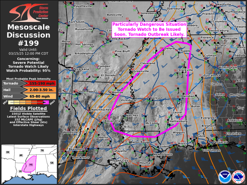
The Storm Prediction Center and local NWS offices are preparing to issue a Potentials Dangerous Situation Tornado Watch for parts of the area.
Summarizing the SPC Discussion:
A tornado outbreak is likely today across eastern Louisiana and Mississippi, with conditions increasingly resembling past high-impact tornado events. Morning data confirms that key ingredients for significant tornado development are in place, including rich low-level moisture beneath a steep elevated mixed layer (EML), which will support strong instability throughout the day. The EML will also help suppress widespread convection early on, favoring the development of discrete, long-lived supercells, which are the most concerning storm mode for strong tornadoes.
Wind shear is already strong across the region and will continue to intensify as a deepening low-pressure system strengthens the low-level jet to 65-70 knots by mid-afternoon. This will create extreme conditions for tornado development, with low-level helicity values supporting efficient stretching of ambient vorticity. As a result, multiple supercells will likely develop across Louisiana later this morning, with bands of tornado-producing storms expected to persist well into the evening.
Given these factors, today’s environment is highly conducive to a tornado outbreak, with multiple, intense to violent, long-track tornadoes expected. The greatest threat window begins around midday and continues through the evening across eastern Louisiana and much of Mississippi. To address this high-end tornado threat, a Particularly Dangerous Situation (PDS) Tornado Watch will be issued soon. This is a serious and potentially life-threatening situation—have multiple ways to receive warnings, know where to take shelter, and take all alerts seriously.
In English: The factors that go into making a significant severe weather day are in place. That includes the ability for the atmosphere to produce strong, long-track tornadoes. While we won’t see storms develop for another few hours in many spots, once they do start to go up, the storm mode will start out with discrete supercells and then a line of storms will press through the area.
Have multiple ways to be alerted by the NWS for watches and warnings today. And keep an eye to the sky.


Thank you as always, Nick. You keep us calm, even in the worst of storms.
Keeping a CLOSE watch on the radar. Just west of here now. Glad we have someone we can rely on to keep us aware of what’s going on … even on a weekend! MANY thanks!