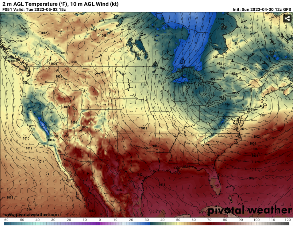
With the last trough moving out of the Southeast and low pressure system moving out of the Great Lakes, we’ll see some very pleasant weather for the next few days with drier air moving in. Like it has been for the past few months, however, it’ll be cut short by another set of troughs pushing in from the West with on and off rain chances for the weekend.

As shown above, the low from Saturday is moving fairly slowly out of the Northeast which means that the northwesterly flow at the surface is going to hang around for a few days which means that all the air will be dry and pleasant for early May. A surface high pressure system will also develop out of this which will block off any chance of rain through the mid-week, but temperatures will begin to climb as the high breaks down. With all of this, pleasant, dry weather for most of the week!

Friday is the first chance of rain. A surface low will slowly move into the Great Plains and will pull in Gulf moisture to bring in scattered rain chances across the Pinebelt and the southern part of Louisiana. Temperatures will be in the mid-80’s for most of the weekend so expect it to be warm and humid with the scattered rain. Saturday will also have another chance for rain with a few other scattered showers, however the surface trough will begin to break down which may inhibit the rain as compared to Friday.
Looking at both the mid-levels and the surface, Sunday is our biggest chance for rain with a trough developing from the Rockies pushing northeast. This trough is slightly more well-developed compared to the last one and will likely bring more rain to the coast and Pinebelt since it has a little more “push” to it. Rain could reach up to over an inch for some areas.


So far, the Storm Prediction Center doesn’t have an outlook for any of these systems yet. Partially because of how far out they are, and also because these systems are fairly weak. There isn’t a lot of dynamic flow for both of the low’s which inhibits any sort of straightline winds and tornadoes, but that doesn’t mean that it can’t happen. Hail could be possible with a few dry slots in the Skew-T’s and lightning is also possible. For now, the main concern is rain and how much, especially later in the weekend. These systems are fairly slow moving due to the lack of dynamic movement which means that they’ll hang around for a few days before they make their exit. We will keep you updated throughout the week!
Regional Day-to-Day Forecast
This Afternoon – Sunny, with a high near 77. West northwest wind around 10 mph, with gusts as high as 25 mph.
Tonight – Clear, with a low around 53. West northwest wind around 5 mph becoming calm in the evening.
Monday – Sunny, with a high near 78. West northwest wind 5 to 10 mph increasing to 10 to 15 mph in the afternoon. Winds could gust as high as 20 mph.
Monday Night – Clear, with a low around 51. Northwest wind around 5 mph becoming calm in the evening.
Tuesday – Sunny, with a high near 81. Light northwest wind becoming west northwest 5 to 10 mph in the morning.
Tuesday Night – Partly cloudy, with a low around 55. Northwest wind around 5 mph becoming calm in the evening.
Wednesday – Sunny, with a high near 80. North northwest wind 5 to 10 mph.
Wednesday Night – Clear, with a low around 53. North wind around 5 mph becoming calm in the evening.
Thursday – Sunny, with a high near 86. East wind around 5 mph becoming south in the afternoon.
Thursday Night – Mostly cloudy, with a low around 62.
Friday – A 30 percent chance of showers and thunderstorms. Partly sunny, with a high near 87.
Friday Night – A 20 percent chance of showers and thunderstorms. Mostly cloudy, with a low around 66.
Saturday – A 30 percent chance of showers and thunderstorms. Partly sunny, with a high near 88.
(adsbygoogle = window.adsbygoogle || []).push({});
