A couple of big hitters for today:
1. It will be windy
2. There will be storms this evening and then overnight
3. Some of those storms will be severe
4. A few of those severe storms will produce tornadoes
5. One or two of those tornadoes may be strong (EF-2 or stronger)
6. Flooding is also a concern
Like always, not everyone will see severe weather. Not everyone will get the “worst” storm. That will only be a select few. But the ceiling for how potent any one storm can be is pretty higher today, especially for folks living on the eastside of I-59.
For those of you who recall watching me on TV I try to break the threat for severe storms down like this:
WHO SEES WHAT DURING THE STORMS?
EVERYONE — Very breezy conditions, brief rain shower with lightning, wind gusts up to 50mph
MOST AREAS — Very breezy conditions, brief heavy rain, lightning, wind gusts up to 55mph
SOME PEOPLE — Very breezy conditions, one extended round of heavy rain, frequent lightning during the rain, wind gusts up to 60mph, small hail
FEW SPOTS — Very breezy conditions, very heavy rain, brief localized flash flooding, frequent lightning during the rain, wind gusts up to 70mph, hail up to the size of quarters, the chance for a tornado (up to EF-3 in strength)
TIMELINE FOR SEVERE RISK
WEST — 5p through 1a
CENTRAL — 8p through 3a
EAST — 10p through 5a
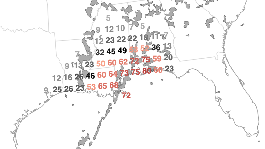
Looking at the NCAR Neural Net forecast for the chance you see a warning, the numbers are down slightly this morning. Buit still higher than 50-percent.
The SPC and WPC have held their outlooks overnight. The only change was the WPC inching the Moderate Risk for flash flooding back to the east a bit.


For a county-by-county breakdown of the severe weather threats and timeline for the local area, check this out: https://www.nickelblock.com/1-7-24-915p-update-windy-everywhere-with-severe-weather-possible-and-localized-flash-flooding-likely-monday/
I think this morning’s data suggests an even finer line between the have’s and the have not’s for severe weather. The image below I’ve painted on three lines. A red line, an orange line and a yellow line.
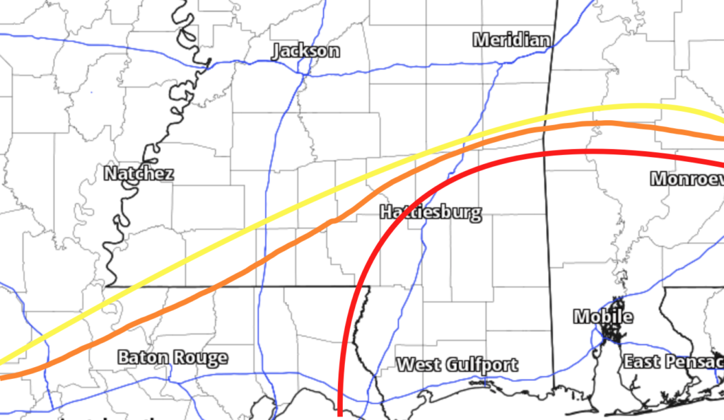
South of the red line, I think is the highest risk for severe weather regardless of how things shake out today.
The orange line indicates the same thing IF we get more daytime heating today and the warm front arrives earlier than model guidance is showing. I think it is a reasonable look at the most likely “change” to the forecast.
The yellow line indicates the reasonable “worst case scenario” for how far north the warm air gets and how widespread the risk for surface-based severe weather (in particular very strong wind gusts and tornadoes) becomes,
All of that said, if you live north of any of those lines, you will still have the chance to see some potent weather today. It just may not be as potent as your friends to the south.
REGIONAL DAY TO DAY FORECAST
Monday: Partly sunny in the morning, then mostly cloudy with showers with a slight chance of thunderstorms in the afternoon. Some storms may be severe. Windy with highs in the upper 60s. East winds 15 to 20 mph with gusts up to 35 mph, becoming southeast 20 to 30 mph with gusts up to 50 mph in the afternoon. Chance of rain 90 percent.
Monday Night: Showers. A slight chance of thunderstorms in the evening, then a chance of thunderstorms after midnight. Some thunderstorms may be severe. Windy and not as cool. More humid with lows in the upper 40s behind the rain, temperatures int eh 60s before it. Southeast winds 25 to 30 mph, becoming south 20 to 30 mph after midnight. Gusts up to 50 mph. Chance of rain near 100 percent.
Tuesday: Mostly sunny. A chance of showers with a slight chance of thunderstorms in the morning. Breezy and less humid with highs in the upper 50s. West winds 15 to 25 mph with gusts up to 40 mph. Chance of rain 50 percent.
Tuesday Night: Partly cloudy in the evening, then becoming mostly clear. Much colder with lows in the lower 30s. West winds 15 to 20 mph with gusts up to 30 mph.
Wednesday: Sunny. Highs in the mid 50s.
Wednesday Night: Partly cloudy. Lows in the mid 30s.
Thursday: Partly sunny. Not as cool with highs in the mid 60s.
Thursday Night: Mostly cloudy. A slight chance of showers in the evening, then showers likely after midnight. Not as cool with lows in the lower 50s. Temperature rising into the upper 50s after midnight. Chance of rain 60 percent.
Friday: Mostly cloudy in the morning, then becoming partly sunny. A slight chance of thunderstorms. Showers likely, mainly in the morning. Highs in the upper 60s. Chance of rain 70 percent.
Friday Night: Partly cloudy. A slight chance of showers and thunderstorms in the evening. Much cooler with lows in the mid 30s. Chance of rain 20 percent.
Saturday: Mostly sunny. Much cooler with highs in the lower 50s.
Saturday Night: Mostly clear. Cold with lows in the lower 30s.
Sunday: Sunny. Highs in the upper 50s.


Thank you