Expect weather similar to the past few days. Most storms will develop this afternoon with the peak heat and will continue into the early evening as temperatures drop. There’s a small chance for a stronger storm, but severe weather is not expected. The main concern is the heat, with heat index values between 105-110F. A Heat Advisory is in effect for most of the area.
ACtual temperatures will get as warm at 97F in some spots this afternoon. With Experienced Temperature values (that is when we factor in sunlight, and wind, along with temperature and humidity) between 95 and 105F.


In short: Hot.
And this will stick around for tomorrow, too. But it should start to wane a bit on Thursday. On top of that, we may see some extra showers and storms develop. That trend continues into the weekend. Folks closer to the coast may see some pretty heavy rainfall, increasing the risk of flash flooding.
By Sunday into next week, another high-pressure system will build in, and we will be right back where we started.
A quick note about those 15-day forecasts I posted about on facebook the other day: They’re still a work in progress.
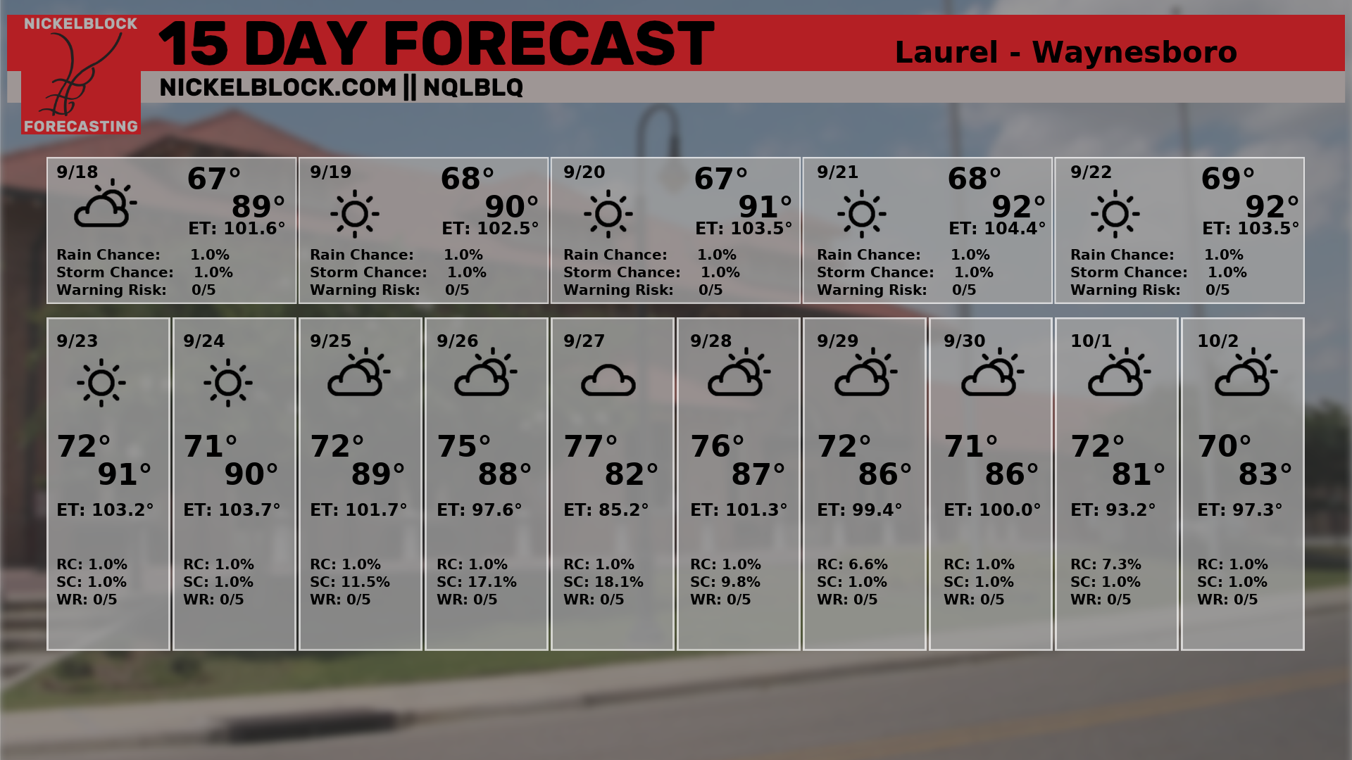
So far, NQLBOT, our AI Weather Helper, has been far too chilly with out afternoon highs beyond Day 5. For example, in the forecast above, look at Saturday’s high! Just 81F! Don’t we all wish! And then next week a string of highs around 80F.
Fat chance.
So, I will continue to work with the data and see if I can’t figure out what our little AI Weather Dude is doing.
REGIONAL DAY TO DAY FORECAST
Today: Mostly sunny. A slight chance of showers and thunderstorms this morning, then a chance of showers and thunderstorms this afternoon. Highs in the mid 90s. West winds around 5 mph, becoming south this afternoon. Chance of rain 40 percent. Heat index values up to 109.
Tonight: Partly cloudy. A slight chance of showers and thunderstorms in the evening. Humid with lows in the mid 70s. South winds around 5 mph. Chance of rain 20 percent.
Wednesday: Mostly sunny. A slight chance of showers and thunderstorms in the morning, then showers and thunderstorms likely in the afternoon. Humid with highs in the mid 90s. Southwest winds around 5 mph. Chance of rain 40 percent. Heat index values up to 109.
Wednesday Night: Partly cloudy in the evening, then clearing. A slight chance of showers and thunderstorms. Humid with lows in the mid 70s. South winds around 5 mph in the evening, becoming light and variable. Chance of rain 20 percent.
Thursday: Mostly sunny. A chance of showers and thunderstorms in the morning, then showers and thunderstorms in the afternoon. Humid with highs in the lower 90s. Southwest winds around 5 mph. Chance of rain 60 percent. Heat index values up to 109.
Thursday Night: Showers and thunderstorms likely, mainly in the evening. Lows in the lower 70s. Chance of rain 30 percent.
Friday: Showers and thunderstorms. Highs in the upper 80s. Chance of rain 60 percent. Heat index values up to 105.
Friday Night: Mostly cloudy with a chance of showers and thunderstorms. Lows in the lower 70s. Chance of rain 20 percent.
Saturday: Partly sunny. A chance of showers and thunderstorms in the morning, then showers and thunderstorms likely in the afternoon. Highs in the upper 80s. Chance of rain 40 percent.
Saturday Night: Mostly cloudy with a chance of showers and thunderstorms in the evening, then partly cloudy with a slight chance of showers and thunderstorms after midnight. Lows in the lower 70s. Chance of rain 20 percent.
Sunday: Partly sunny. A chance of showers and thunderstorms in the morning, then showers and thunderstorms likely in the afternoon. Highs in the upper 80s. Chance of rain 30 percent. Heat index values up to 105.
Sunday Night: Mostly cloudy with a chance of showers and thunderstorms in the evening, then partly cloudy with a slight chance of showers and thunderstorms after midnight. Lows in the lower 70s. Chance of rain 20 percent.
Monday: Partly sunny. A chance of showers and thunderstorms in the morning, then showers and thunderstorms likely in the afternoon. Highs in the upper 80s. Chance of rain 30 percent. Heat index values up to 105.


