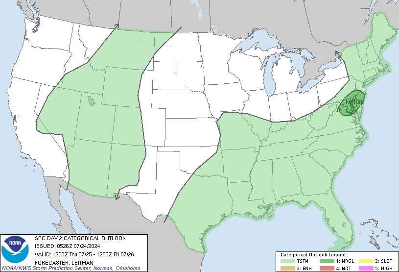
It has been an incredibly wet June for the central and southern planes, and this pattern continues through the mid-week, with showers and thunderstorms expected in the high and central planes, as well as the southeast, some of which could bring flash flooding to this already parched region. As for severe weather, people from central Texas to the Georgia coast need to be prepared for severe storms. The primary threat is damaging winds and hail, but one can’t rule out an isolated tornado or two. Those in central and southern Texas can expect dangerously high temperatures, with record-high temperatures possible.
Flood threat for Southeast and Intermountain West

An wet pattern continues for the west, as well as the southeast associated with the severe weather threat. A cold front from the Gulf of Alaska is expected to increase showers and general thunderstorm activity in the intermountain west. Not only will this front increase the chance for rainfall, it will also keep temperatures below average for the region, so make sure to bring the raincoat and dress for cooler weather on Tuesday 6/13. Burn scar areas as well as areas of snowmelt should see the greatest threat for flash flooding.
As for the Southeast, heavy rain associated with severe weather could increase the threat for flash flooding in the region. Looking at the NAM, the greatest threat for heavy rain is from 7AM to 3PM on Tuesday 6/13, so make sure to carry an umbrella with you. People in low lying areas and poor drainage areas should prepare for flash flooding.
Severe Weather Expected for Southest

A stationary front associated with a low pressure system from the Great Lakes and a trough in the Eastern United States is expected to form over the Southeast Region of the US, bringing an organized set of thunderstorms, some of which could be severe. The primary threat from these storm will be damaging winds in excess of 60 mph, as well as hail greater than 1 inch in diameter. The threat for tornados during this outbreak is low, but that dose not mean one can’t rule out the chance for an isolated tornado. The region with the greatest threat for severe weather is from Northeastern Texas to the Georgia Coast. Some Cities that could see severe weather are Dallas Texas, Shreveport Louisiana, Jackson Mississippi, Birmingham Alabama, and Columbus Georgia.
The Heat is on For Southern Texas and Florida


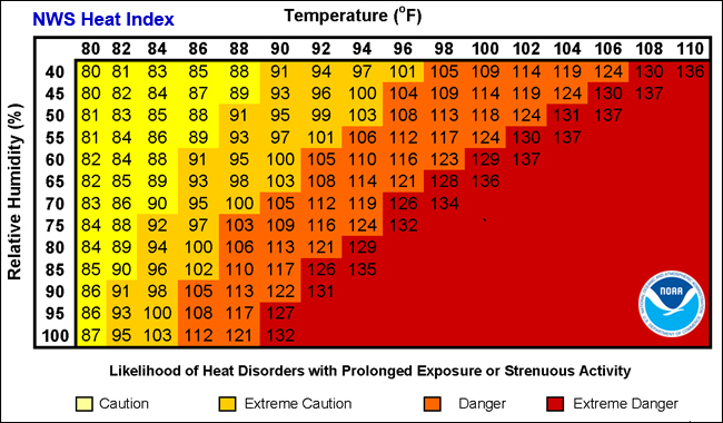
Hot and potentially dangerous temperatures are expected for the southern portion of Texas as well as most of Florida. A ridge of high pressure is currently stationed over the desert southwest, causing hot and humid air to move up from the tropics. The combination of hot air and relatively high humidly will make it fell oppressive in portions of Southwest Texas and most of the Florida Peninsula. Areas in Southwest Texas can expect record breaking temperatures of 110 or higher with heat index values of 120 or greater. These temperatures can induce heat related illness in as little as 30 minutes or less. As for Florida, no record breaking temperatures are expected; although heat index are expected to be greater than 100 degress during the daytime, which is typical for this time of year. People venturing outside in these regions should be prepared for extreme heat and take proper precautions.
Travel Impacts For 6/13/2023
For folks traveling by air tomorrow, the airports that have the greatest chance for seeing delays tomorow are areas that will be impacted by severe weather and rain. Those areas are Atlanta, Birmingham, Dallas, and Denver. Those who will be traveling through those airports should keep an eye on their flight information as well as the current weather at those airports. For those who are planning on traveling by road, drivers in the Southeast and the Intermountain west can expect rain and thunderstorsm, so make sure your windshield wipers are working. For those who plan on driving in Southwest Texas, make sure your cars cooling system is in working order.
Extended Outlook
Areas in the Planes and Mountain West should expect this active pattern to continue for the next several days before warmer and dryer air from the southwest starts to move in; however, expect above average precipitation to continue for the region for the next 7 to 10 days. For severe weather, expect more severe thunderstorms in the southeast for 6/14/2023. After that, the chances for severe weather should be much lower. Most of New England can expect to see rain and cool temperatures later this week from the same canter of low pressure that is causing the severe weather in the Southeast Today. For Southwest Texas, expect the oppressively hot temperatures to continue for the next several day, so make sure to drink plenty of water.
Conclusion
For anyone who likes rainfall the Southeast and the Intermountain West are the best areas to see rainfall, but look for this pattern to switch as dryer air begins to build in these regions. For all the storm chasers out there, the southeast is your best opportunity to see severe storms for the next 48 hours. For anyone who wants hot weather, head to Southwest Texas because the ridge of high pressure as well as the heat will be sticking around the area for the foreseeable future.


