We’re nearing the end stages of our wet July. We’ve had on and off rain chances pretty much every day for over a week, but its been a welcome change to the typical hot-humid-afternoon-thunderstorm type of July we normally get. For those who love the rainy days, sadly, it’ll be a little while before something like this will happen again.
Looking at the mid-level analysis above, we can see a few points of interest that we’ll be looking out for in the next couple of days. First off, there’s plenty of moisture from the Gulf filtering in from the Caribbean and hooking north towards south Texas to Alabama. Second off, two areas of low pressure are located off the Atlantic coast and the mid-Mississippi River Valley. This will hang around for another day until it finally gets its feet and moves further into the Atlantic. This is due to a strengthening upper-level high in the Great Lakes region squeezing it out and another ridge forming in the Gulf.
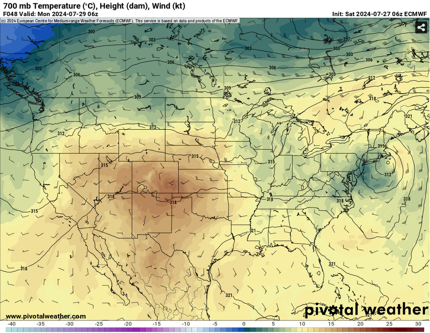
//Courtesy: Pivotal Weather
Before this is all in place, we’ll still have two more days of rain possible.
Today, we’ll have a mix of clouds and sun all day leading to the possible thunderstorms in the mid-afternoon. Around 2-4 will be the highest possible chance for areas in the Pinebelt, however areas closer to the I-20 corridor will see rain starting around noon and it will hang around into the evening. Some storms will be possible around the coastline and linger into the evening hours. Temperatures will reach the upper 80s with the heat index reaching 100 in some areas.
Tomorrow, we’ll have a similar story of on and off rain during the afternoon. The main difference is that we’ll see some northerly influence with these storms in the evening implying that the cold front is on its way out. Temperatures will reach the low 90s with the heat index reaching the low 100s.
Come Monday, we’ll have some overnight showers possible until this cold front moves out. During the day, we’ll reach the low 90s again with partly cloudy skies during the day. A few showers are possible, but most of this looks to be closer to the coastline with the cold front moving towards the Gulf. The heat index will reach the low 100s and the humidity will still be a factor in this heat.
So keep an umbrella with you for the next few days as this system begins to move out. Have a good weekend!
Select Data Set:

Regional Day-to-Day Forecast
Today – Showers and thunderstorms likely in the afternoon. Mostly sunny, with a high in the upper 80s. Heat index values as high as 99. Southeast wind around 5 mph becoming calm. Chance of precipitation is 70%. New rainfall amounts between a quarter and half of an inch possible.
Tonight – A 30 percent chance of showers and thunderstorms, mainly before sunset. Patchy fog after 9pm. Otherwise, mostly cloudy, with a low in the mid 70s. Calm wind.
Sunday – Shower and thunderstorms possible from the mid-morning to the afternoon. Patchy fog before 9am. High in the low 90s. Heat index values as high as 103. Calm wind becoming southwest around 5 mph. Chance of precipitation is 80%. New rainfall amounts of less than a tenth of an inch, except higher amounts possible in thunderstorms.
Sunday Night – Isolated showers and thunderstorms possible overnight. Patchy fog after 9pm. Otherwise, mostly cloudy, with a low in the mid 70s. Calm wind. Chance of precipitation is 20%.
Monday – Isolated showers possible in the early morning, then a slight chance of thunderstorms in the afternoon. Patchy fog before 9am. Otherwise, mostly sunny, with a high in the low 90s. Calm wind becoming west southwest around 5 mph. Chance of precipitation is 60%. New rainfall amounts of less than a tenth of an inch, except higher amounts possible in thunderstorms.
Monday Night – Partly cloudy, with a low in the mid 70s. Calm wind.
Tuesday – Showers and thunderstorms possible in the afternoon. Sunny, with a high in the low to mid 90s. Calm wind becoming west around 5 mph. Chance of precipitation is 50%.
Tuesday Night – Partly cloudy, with a low in the mid 70s. Calm wind.
Wednesday – Scattered showers and thunderstorms, mainly in the afternoon. Sunny, with a high in the mid 90s. Calm wind becoming southwest around 5 mph. Chance of precipitation is 40%.
Wednesday Night – Mostly clear, with a low in the mid 70s.
Thursday – Scattered showers and thunderstorms. Sunny, with a high in the mid 90s. Chance of precipitation is 40%.
Thursday Night – Mostly clear, with a low in the upper 70s.
Friday – Scattered showers and thunderstorms. Sunny, with a high in the mid 90s. Chance of precipitation is 40%.


