Lots of wild weather as we continue through August. Storms coming in the midwest today and over the weekend while the southern US stays dry and hot. We also are watching some destructive wildfires spanning across Hawaii. Let’s get into all the action!
Storms in the Plains, Midwest, and Northeast
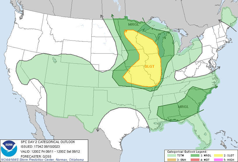
SPC Outlook for Friday 12Z to Saturday 12Z 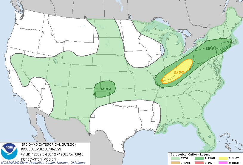
SPC Outlook for Saturday 12Z to Sunday 12Z
This morning the upper midwest will be seeing a storm system move eastward across to the northeast by Sunday morning. The plains region will also see some showers and thunderstorms Sunday and the midwest will get another rain system Sunday evening. This system will have more damaging thunderstorms into Monday morning with possible high winds, hail, and heavy rainfall. This storm system will move into the Northeast Monday night. This pattern of storms is in part from moisture in the air as well as a trough spanning across the area.
Heat Across Southern US
The southern US is still experiencing extreme heat. Highs will be in the upper 90s and low 100s for much of Texas, New Mexico, Arizona, and the Gulf states. This region will remain very hot over the next week with lows not giving much cooling overnight. Over Texas is a ridging pattern with will remain stable and grow over the weekend. These warmer temperatures will creep up into the plains region brining some above average highs. Be cautious when being outside for extended period of times and check the local heat risk for your area.
Hawaii Wildfires
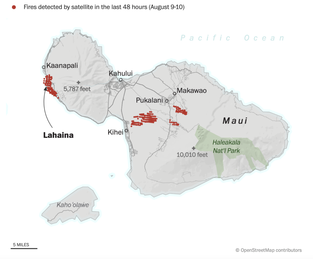
Looking out at the Hawaiian islands we are seeing some big wildfires spreading out on the big island and on Maui. Wildfires have burned hundreds of acres and unfortunately taken the lives of 53 people. The strong winds from Dora off the coast is helping spread the fire across the region. The town of Lahaina has taken the most of the fire. The fire is about 80% con gained but many people are displaced and in a state of chaos. It seems as these fires will be under control soon with more resources on the way hopefully no more lives are lost in these fires.
Travel Impacts
If you are traveling in the midwest metro regions be prepared for flight delays or cancelations especially on Sunday night. Traveling across I-80 will be rainy and windy so drive with caution. Always try to avoid unnecessary travel in wet weather conditions. As for the southern US make sure you travel with some AC because it will be hot! Be sure to check local traffic reports before traveling especially in the northern US this weekend.
Extended Outlook
CONUS will be pretty average or dry for precipitation after this week. A small region of Colorado in the Rocky Mountains will see slightly above average precipitation. The southeast will be slightly drier than average most likely due to the lack of tropical activity in the area. Much of the US will be on average which for some regions may just be dry or others just less rainfall.
The south will remain hot as the temperature mean will be in the 90s for the southern half of the US. Arizona and Southern California will see the greatest heat but Texas and the Gulf states will see a lot of heat as well. This pattern will continue for the next few weeks as the one of the hottest months continues.
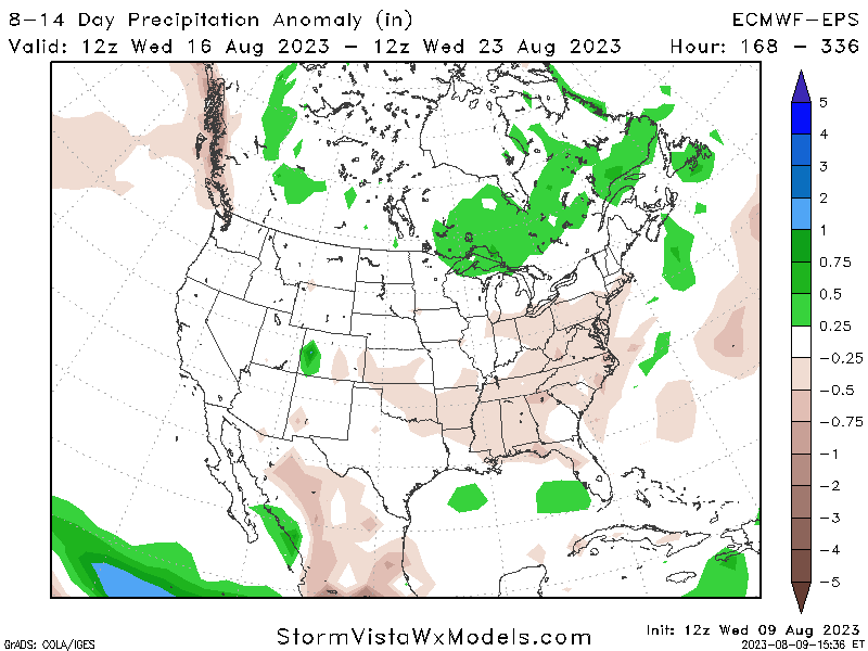
Precipitation Anomaly for 8-14 Days 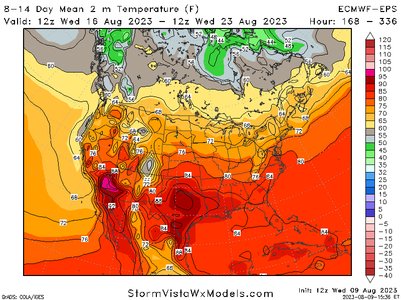
Temperature Mean for 8-14 Days
Conclusion
We will continue to see a stormy pattern this weekend into the early weekend across the midwest and northeast. On the flip side the south will remain dry with extreme heat. This heat will continue for the next few weeks as summer continue along. in Hawaii the wildfires are getting support to be contained hopefully soon with no more loss of life. be sure to check your local forecast for more detailed information!

