As we’ve reached the middle of August, we’ve seen around two week’s worth of highs in the upper 90s to low 100s and unfortunately, it’s not stopping anytime soon. While what could be some rain in the middle of the week may give us some hope, unfortunately it’s just a big tease before we go right back into what we’ve already been dealing with.
The Upper Levels

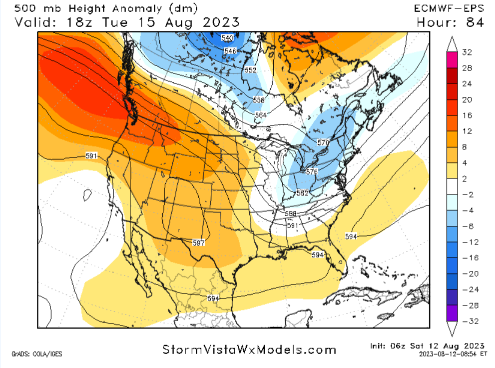
The upper levels show a mostly linear eastern front starting off. Those two ridges I mentioned last week still remain in both the Southwest and Atlantic Ocean and break down just enough to allow the cold front through around Monday and Tuesday. Soon after, there will be a lull by the end of the week. Most all of the eastern US and some of the central US will be under the ridge as shown by the image above. Any sort of dynamic movement has moved far north and the trough in the Pacific is going to stay right there.
One of the reasons for this looks to be is the high pressure zone over Alaska beginning to weaken a bit. As it begins to break down, the low over the Pacific begins to form and the high pressure over the western US will slowly move east. With another trough in Canada moving east, there won’t be much movement south of the border.
This Weekend into Next Week
To no one’s surprise, this weekend is going to be hot. Temperatures will reach the low 100s across most of central and south Mississippi and Louisiana. Temperatures may reach up to 105 depending on where you are. Heat indices will also be dangerously hot with some reaching over 110 especially in the Pinebelt.
Here’s the kicker, though. Be forewarned about burning anything this weekend. The humidity is slightly lower than usual for this time of year which also means that a lot of the fuel for wildfires is primed due to the lack of rain. With barely any relief this weekend, be extremely cautious about where and what you’re burning.
Starting off this coming week, temperatures will remain the same for Monday with a possible evening shower that may spark from the cold front. This looks to be a slightly organized system from the diurnal heat and the front squeezing out enough moisture before sunset.

Tuesday will see our slightly larger chance for rain as the cold front drags across south Mississippi and Louisiana. A line of storms looks possible especially closer to the coastline by the evening. The rain itself may locally produce up to half an inch, however most will probably see a tenth to a quarter of an inch when all is said and done.
Later in the Week
The cold front has passed through by this point and will give us a tiny break in the heat for Wednesday and possibly Thursday. Temperatures will be in the mid and upper 90s for both days with a possible stray shower each day. The same goes for Friday and Saturday, however we will return to our extremely hot conditions again.
Sunday?
Here’s where things get a little weird, and I will also say, not sure if it will happen. While I was scrolling through the models, I noticed a possible backdoor front forming off of Florida that looked like it was moving towards the central Gulf and up towards MS/FL/AL. This could be rain, it could be a blob. The GFS and the Euro both agree that something is forming around Florida after the cold front passes, however they both disagree on what it will do. For now, we’ll have to wait until we get some shorter range model guidance to see what it is.

Select Data Set:

Regional Day-to-Day Forecast
Today – Sunny and hot, with a high near 102. Heat index values as high as 114. West wind around 5 mph.
Tonight – Clear, with a low around 79. West wind around 5 mph becoming calm.
Sunday – Sunny and hot, with a high near 102. Heat index values as high as 114. Calm wind becoming west around 5 mph in the morning.
Sunday Night – Partly cloudy, with a low around 79. South wind around 5 mph becoming calm in the evening.
Monday – A 20 percent chance of showers and thunderstorms in the afternoon. Sunny and hot, with a high near 101. Heat index as high as 111. Calm wind becoming southwest around 5 mph in the afternoon.
Monday Night – Mostly clear, with a low around 78. South southwest wind around 5 mph becoming calm in the evening.
Tuesday – A 40 percent chance of showers and thunderstorms in the afternoon. Sunny and hot, with a high near 97. Calm wind becoming northwest around 5 mph in the afternoon. Winds could gust as high as 20 mph.
Tuesday Night – A 30 percent chance of showers and thunderstorms. Mostly clear, with a low around 71. North wind around 5 mph becoming calm in the evening. Winds could gust as high as 20 mph.
Wednesday – A 20 percent chance of showers and thunderstorms. Sunny, with a high near 94. Calm wind becoming east around 5 mph in the afternoon.
Wednesday Night – Mostly clear, with a low around 71. East wind around 5 mph.
Thursday – A 20 percent chance of showers and thunderstorms. Sunny and hot, with a high near 98. West wind around 5 mph.
Thursday Night – Mostly clear, with a low around 75. South wind around 5 mph.
Friday – A 30 percent chance of showers and thunderstorms. Sunny and hot, with a high near 99. South southeast wind around 5 mph.

