THERE’S A NEWER POST! GET THE LATEST UPDATE ON TROPICAL STORM DEBBIE HERE
About 24 hours ago I mentioned that it would be about 24 to 36 hours before we started to get good model data and could actually start to get a better idea about where this next thing may go.
Here we are about 24 hours later with a better idea about where this thing may go. And the track has shifted a bit to the west.

Of the potential scenarios mentioned this morning, we ended up with “Number 3”
SCENARIOS
- It cross north of Cuba and and turns north up the west coast of Florida making landfall as *something* between Tampa and Panama City.
- The system crosses through Cuba and doesn’t really get orgnaized until after the island, and moves a bit slower, this allows it to meander farther west.
- Invest 97L passes south of the island with convection firing more int he Caribbean than in the Atlantic, this means a wider track into the Gulf and also farther west.
This was the least likely scenario, but happened all the same. That is the tough part about forecasting tropical development – particularly near any land. Weird things happen.
MODEL DATA
In this case, the center formed south of the island of Cuba – aided by the northerly nudging it was receiving aloft that I mentioned last night. This means the track for Tropical Depression 4 (eventually to be named “Debbie”) has shifted to the west.
I want to reiterate here: This was expected given the way the system formed today.
So no surprises here.


Landfall is still shown in ‘roughly’ the same area, but instead of scraping up the western Florida coastline, it looks to bow out into the Gulf a bit farther. I would bet that landfall will continue to shift west, too. This trend may continue for another 12 to 18 hours, with the track shifting to the west as TD 4 getting better organized.
The 18z AIFS model (not known for much specific skill with tropical weather forecasting) tonight, I think, does a reasonable job identifying the possible track with its 500mb forecast.
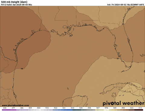
Not perfect, by any means, but a good look at where I think future forecasts may lean toward.
POTENTIAL IMPACTS
As much as I wish I could do a big long portion of this post on the potential impacts for certain areas, I can’t. I don’t think we know enough about the “top end” of TD4 to know for cure what the specific impacts for specific areas will be.
But I will highlight some areas I think will see meaningful tropical impacts (more than just some rain and a breeze). That means, storm surge, heavy rain and flooding, wind gusts strong enough to take down trees and the potential for a few tornadoes.

I would put money on those impacts trending farther north into Georgia and sneaking into more of Alabama, too. Not much, but some. I also am uncertain about how far east we see impacts for the Florida peninsula.
But any more specific than, “There will be some issues” is a bit too difficult to nail down.
CAVEATS & ASTERISKS
I know you guys need more info than I’m giving. Especially folks in Florida. This thing i only a few days from landfall and it probably feels like there isn’t enough consistent data out there to inform your decision-making process.
You’re probably asking, “Do I need water and supplies for a week without power? Or will this be just some wind and rain?”
The reason I don’t want to go “Full Bore” tonight with the center just forming and things just starting to come together is that we are JUST starting to get meaningful model data. The first data isn’t the best data. The best data will start to roll in overnight tonight and through the day tomorrow.
On top of that, I think there is some risk that this system develops quickly once it gets past Cuba and into the Gulf. And I would argue the “top end” for this storm is probably higher than normal for a few reasons:
1. Water temperatures are unseasonably warm
2. The 26C isotherm is quite deep
3. The lack of upper-level wind shear will be quite favorable
4. As it gets halfway through the Gulf, we may see downstream venting
5. There is a chance it moves pretty slowly at times
I won’t bother you guys tonight with the details about those five things I mentioned there, but know that those five things will play a role in how strong it gets – and there isn’t much risk out there to keep TD4 from becoming a hurricane.
With all of that said, the above qualifiers make it difficult to nail down specifics and give you guys a full blown update. The caveats and asterisks add uncertainty to an already difficult forecast.
But hang in there, I think we will start to get a better idea about how things will shake out tomorrow morning and through the day tomorrow. I know that doesn’t give folks in Florida a lot of time, but it is an honest assessment of the available data.


