Tropical Storm Debbie now has wind of 45mph. And it continues to organize.
Here is the latest from the NHC:

Looking at the infrared imagery tonight, Debby looks messy, but is organizing. And looks markedly better than it did this morning.

As we move through the overnight hours tonight, we are likely to continue to see development and organization due nocturnal heat release. This is when storms erupt overnight and help to organize a system. I’ve got more on that later in this post.
The NHC explained in their latest discussion that the NOAA and Air Force Reserve Hurricane Hunter aircraft have been monitoring Tropical Storm Debby and found that its winds have strengthened slightly, with the central pressure dropping to 1003 mb. The current wind speed is about 45 mph.
Debby is slowly turning northward and is expected to move over the eastern Gulf of Mexico, heading towards the Florida Big Bend region within the next couple of days. After that, it will move slowly across northern Florida and towards the coasts of Georgia and South Carolina. This slow movement means there will be significant rainfall and flooding risks.
The conditions are favorable for Debby to get stronger as it approaches Florida, with very warm water temperatures supporting this intensification. There is a possibility that Debby could become a hurricane before it reaches the coast, with wind speeds potentially increasing significantly over the next day and a half. After landfall, the storm will weaken, but its future strength depends on how much time it spends over the Atlantic waters.
Key Points:
- Expect heavy rainfall and potential flash and urban flooding across parts of Florida and the Southeast through Thursday, with significant river flooding also likely.
- Hurricane conditions are expected on Monday in the Florida Big Bend region, with tropical storm conditions starting late Sunday in areas further south, including Tampa Bay and the Lower Florida Keys.
- There is a danger of life-threatening storm surge along the Gulf coast of Florida from Aripeka to Indian Pass. Life-threatening storm surge is also possible from Aripeka to Bonita Beach, including Tampa Bay and Charlotte Harbor.
- Storm surge, strong winds, and heavy rains could impact other areas in Florida and the southeastern U.S. from Georgia to North Carolina through the middle of next week. Stay updated as more watches and warnings may be issued.
Along the lines of potential intensification, one thing worth looking at is the placement of the mid-level trough to the north and how it is impacting the general synoptic environment around Debby.
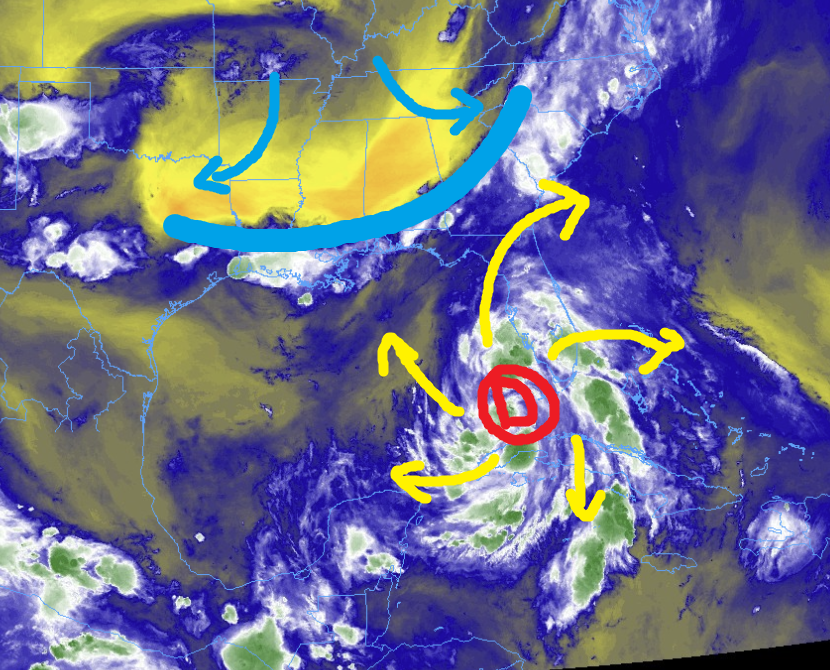
It is helping to vent Debby to the north. While the westerlies to the south of the system are helping to vent the system on the southside, too.
This venting, helps to facilitate the movement of warm and humid air from the surface aloft and then exporting that air away from the system once it has ascended. This sets up a conveyor belt for intensification.
MODEL DATA
Looking at the model data, we continue to get better data in now that the system has formed and the models have a “Center” of a storm to grab ahold of. The animation below doe sa good job to highlight how the forecast has shifted since the system formed.
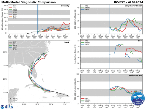
The latest model guidance follows along with the NHC forecast just fine. Nothing here is surprising or odd. I will say the intensity forecast (below, left) may be under-doing it, depending on how Rapid Intensification goes (if at all).


The track forecast (above, right), shows a majority of models taking the system into the Big Bend region of Florida near Apalachee Bay.
As mentioned in previous forecasts, I do have some question about the forward speed of the system as well as the track northward given some of the model data versus what is happening in the real world. But I won’t get into that for this post.
RAPID INTENSIFICATION NUMBERS
After reading up on a few papers, I found one that may be applicable to this situation. Titled, “Diurnal Variations in Tropical Cyclone Intensification” in Geophysical Research Letters of the AGU.
This paper examines daily patterns in how tropical cyclones (TCs) strengthen and weaken over the ocean, using data from 1982 to 2017 across all global TC basins. The study finds that TCs tend to intensify most between 3 AM and 9 AM local solar time, but there are no daily patterns for when TCs weaken. The most frequent and rapid intensification occurs during early morning hours and is associated with large areas of very deep convective clouds. This early morning intensification is linked to the TC’s spin-up process, driven by the daily circulation of very deep convection.
As Debby is getting better organized this evening, we are looking at model data that shows stuff like this:

The main part to look at is the section down bottom where it shows the percent-chance of Rapid Intensification during a given time period. This shows a 40-percent chance for gaining 45kts, 55kts and 65kts during the next 36, 48, and 72 hours.
In English: the SHIPS model is suggesting Rapid Intensification is possible. PErhaps even “likely” in this case. These numbers are 7x and 8x the normal values we see historically.
Another way to look at it is with the charts below.

All signs are pointing toward – at least – general better organization and strengthening. But the data also supports a chance at Rapid Intensification.
FORECAST TRACK DETAILS
I tend to think the forecast track may hold. For a few reasons. Despite my background concerns about it being picked up and swept a bit farther west, i think that even if that does happen, we may still see the system end up in the same spot eventually — the northern coast of Florida.
A stronger system is going to feel the pull of Coriolis a bit more. So if the system wraps up and starts to really strengthen, we will see it start to get tugged northward and northeastward.
So, if it is pulled west, it will spend more time over warm water and start to strengthen and then turn back to the north and northeast.
Is there a chance it swings back to the west a bit more and makes landfall closer to Port St. Joe or Mexico Beach? I think so. But there isn’t enough data right now to support the system making landfall much farther west than that.
What about farther east or down the peninsula of Florida? That seems less likely, but still possible. Perhaps as far south as Tampa Bay. But, if that is to happen, the trajectory of the system would be nearly due North, so it would scrape all the way up the coast.
But that likelihood is quite low.
LOCAL IMPACTS
This is likely going to be a big rain producer, a big surge producer and a tornado producer for Florida, southeastern Georgia and South Carolina.
Here are the latest details from the NHC:
SUMMARY OF WATCHES AND WARNINGS IN EFFECT:

A Storm Surge Warning is in effect for...
* Florida coast from Aripeka northward to Indian Pass

A Storm Surge Watch is in effect for...
* Florida coast from Bonita Beach northward to Aripeka, including
Tampa Bay and Charlotte Harbor

A Hurricane Warning is in effect for...
* Florida coast from the Suwannee River to the Ochlockonee River

A Hurricane Watch is in effect for...
* Florida coast west of the Ochlockonee River to Indian Pass
* Florida coast south of the Suwannee River to Yankeetown

A Tropical Storm Warning is in effect for...
* The Florida Keys west of the Seven Mile Bridge including the Dry
Tortugas
* Florida coast south of the Suwannee River to East Cape Sable
* Florida coast west of the Ochlockonee River to Indian Pass

A Tropical Storm Watch is in effect for...
* The Florida Keys north of the Seven Mile Bridge to the Channel 5
Bridge
* Florida coast west of Indian Pass to Mexico Beach
RAINFALL: Tropical Storm Debby is expected to produce rainfall
totals of 6 to 12 inches, with maximum rainfall totals up to 18
inches, across portions of Florida and along the Southeast U.S.
coast this weekend through Thursday. This rainfall will likely
result in areas of considerable flash and urban flooding, with
significant river flooding expected.

TORNADOES: A tornado or two is possible across the Florida Keys and
the southern and western parts of the Florida Peninsula through
tonight, expanding across much of northern and central Florida on
Sunday.

SURF:  Swells generated by Debby are expected to affect much of the
Gulf coast of Florida tonight through Monday and along the Southeast
U.S. coast early next week. These swells are likely to cause
life-threatening surf and rip current conditions. Please
consult products from your local weather office.


Been watching the visible satellite loop and it has made a definite turn to the north. BTW, I think your spelling (Debbie) in your intro is more correct than Debby. Oh yeah, what’s up with your email … bounces back each time I try to send?