I want to offer a brief look at some of the riff-raff in the Tropics. The National Hurricane Center is now watching three areas in the Atlantic.

Only one area – a wave in the middle of the Atlantic – shows any reasonable chance of development during the next week.
IT’S BEEN QUIET… A LITTLE TOO QUIET
To borrow a quote from Teenage Mutant Ninja Turtles, the “a little too quiet” coming to an end as the standing wave of supression looks to break down as we head past the 10th of September.

The chart above is a little tough to wrap your brain around (in my opinion, but other people can read it just fine) but what it shows is the blobs of red on each date sitting on top of the Atlantic. The big black box Ive drawn in those the “area” in the atlantic the red area is blobbed over.
And at the bottom of the chart it shows the blob starting to release its hold.
That is part of the reason the model guidance is starting to actually show tropical waves developing.
TIMELINE OF EVENTS
The first area of interest in the Gulf will likely continue to impact our local weather in the Southern MS/AL/LA region for the next few days – indirectly. We will have extra showers and storms each day with a pretty humid airmass in place and a southerly flow.
Even if we see “development” from the area in the Gulf now, it wouldn’t change our local impacts: More rain.
So from August 31st through Sept 4th, expect to see extra rain along the central Gulf Coast, but that’s about it.
Of the three areas of interest, only two are really showing up in the European Model Ensemble model guidance. One looks to enter the Caribbean during the next seven days. The other looks to remain offshore as a “fish storm” only bothering the fish and mariners.
That development is expected somewhere between September 5th and September 10th.
The map below shows the track of each system across 51 different ensemble members of the Euro model guidance.

Looking at the numbers under the L’s will tell you the strength each ensemble member thinks the systems will be. None are overly impressive.
But that isn’t really great news.
We want – well, friends, we NEED – each storm to wrap up quickly and gain strength quickly. That will make certain that each storm turns north before getting anywhere near the Gulf.
But we don’t see that right now.
Below, the map of the operational model guidance from the American, GFS model, shows a pretty weak and broken up wave traversing the Caribbean. It is shown as the “W” near the Yucatan on September 8th.
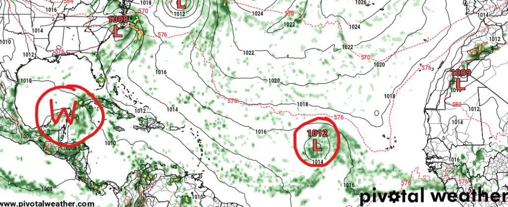
The second wave, here, is shown as wrapped up and already moving northward.
Given this, know that between now and September 7th, we have almost nothing to worry about. Beyond that, we start to watch for this wave in the middle of the Atlantic to get closer to home. And if – big IF here – it were to do anything it would be between the 9th and 14th of September.
If. Big if. We are still way too far out to know what – if anything – may happen.
BOTTOM LINE
Keep tabs on the forecast in the tropics in the coming days, but know there isn’t anything to really worry about happening locally until later this upcoming week.
Aug 31st through Sept 5th: Monitor system in the Gulf for extra rain – but development or not won’t change local impacts.
Sept 7th through Sept 10th: Keep eyes on the potential development of a system in the Caribbean.
Sept 11th through Sept 15th: Potential impacts from said system somewhere between Belize, Brownsville, Biloxi, and the Bahamas.
A lot of uncertainty at this point.
But, having systems floating around out there is a good reminder to make sure your hurricane kit is ready to go and your hurricane plan is set and everyone in your family knows what to do!


