We’ve got a lot to talk about this evening, so let’s get started! First, Debby is now a hurricane and is forecasted to make landfall late tonight in Florida. To the west of Debby, hot and dry conditions are likely this week from Kansas to Alabama. Finally, heavy rain is possible later this week across the Northeast due to Debby and a system that is forecasted to move across the Upper Midwest.
Hurricane Debby to Cause Major Impacts
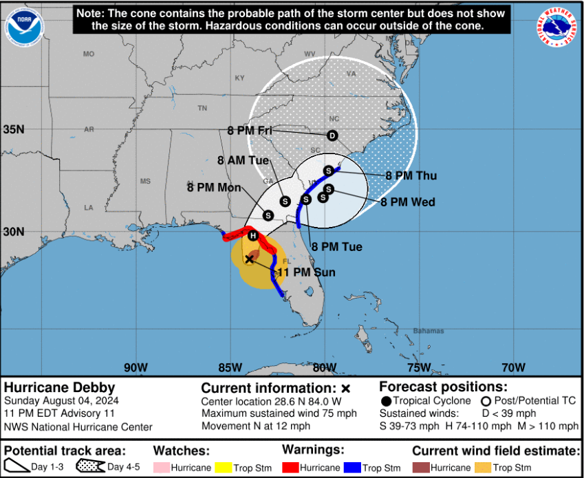
As of the 10 pm EDT update, Hurricane Debby now has winds of 75mph as the system continues to move northward toward Florida.
Hurricane conditions will begin to take place late tonight into tomorrow morning in the Florida Big Bend region, with tropical storm conditions beginning late this evening.
Life-threatening storm surge is possible along the Gulf Coast of Florida from Horseshoe Beach to Indian Pass. Storm surge is also likely southward from Tampa Bay to Fort Myers Beach.
The main concern with Debby is the heavy rainfall and the likelihood of flash and urban flooding across Florida, Georgia, and the Carolinas over the next few days.
Significant river flooding is also likely with strong winds, storm surge, and heavy rain. Storm Surge warnings are in effect on the Atlantic side from Fernandina Beach, FL to McClellanville, SC.
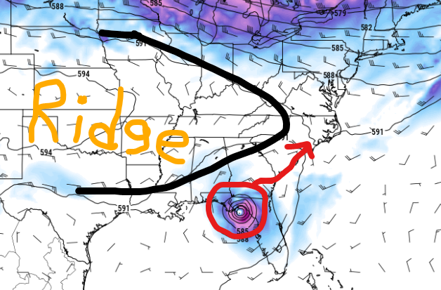
This week, ridging in the mid-levels of the atmosphere will act as a blocker and not allow any fronts or troughs to kick this thing out to sea. Instead, Debby is forecasted to hang around in the Southeast this upcoming week.
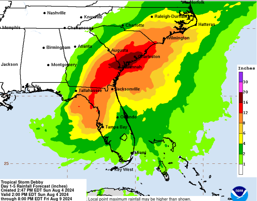
This will be a widespread and life-threatening flooding event! Over 6″ of rainfall is likely from Tampa Bay, FL to Cape Hatteras, NC and this isn’t even including storm surge. The bullseye for catastrophic flooding includes cities such as Savannah, GA, and Charleston, SC where rainfall may exceed 15″.
The Carolinas have already picked up a lot of rainfall this past month, so these areas will flood easily. The city of Charleston can flood very quickly, so please take this storm seriously. If you are asked to evacuate, do so, and be sure to take the most important belongings out of your house. It may take days or weeks for the water to recede along the Southeast coast.
After that, Debby will move northward towards the Mid-Atlantic and the Northeast, bringing more torrential rainfall and impacts later in the week.
Southern U.S. Heat
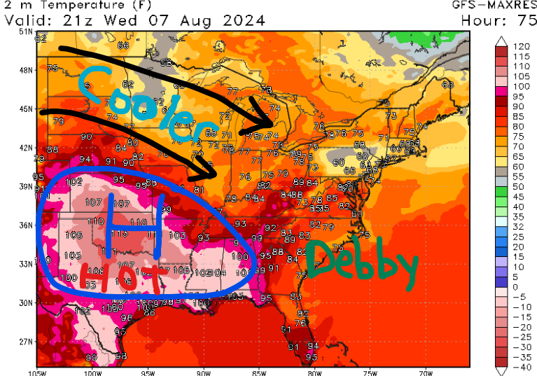
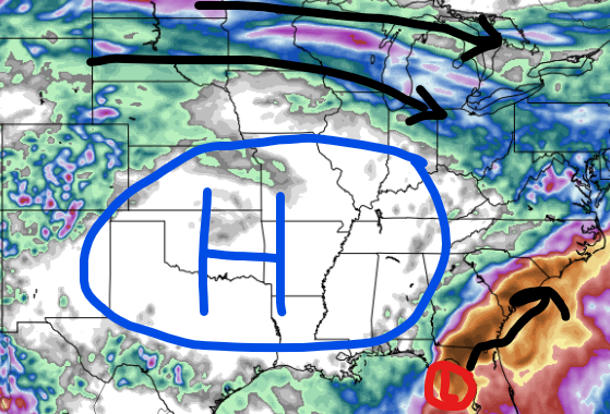
A strong area of high pressure is forecasted to build across the central and southern U.S. this week. This allows for a lot of sinking air at the surface and drier conditions. Over the next few days, temperatures will be above average for much of the South due to limited cloud cover and the lack of troughing.
Afternoon high temperatures will likely exceed 100 degrees in southern Kansas, Oklahoma, Texas, southern Arkansas, Louisiana, Mississippi, Alabama, and possibly the Florida panhandle. The strength and location of this high will determine where Tropical Storm Debby will go next as the storm is forecasted to slow down.
Heat advisories have been issued for eastern Louisiana, central and southern Mississippi, and southern Alabama. If you live in one of the states mentioned in the paragraph above, please drink a lot of water this week and avoid going outside during the afternoon hours. Heat illness can occur quickly, so find shady areas if you have to work outside.
There is a slight cooldown possible for the central U.S. late this week to due mid-level troughing, so this could be the last week of really intense heat for many.
Northeast Rain
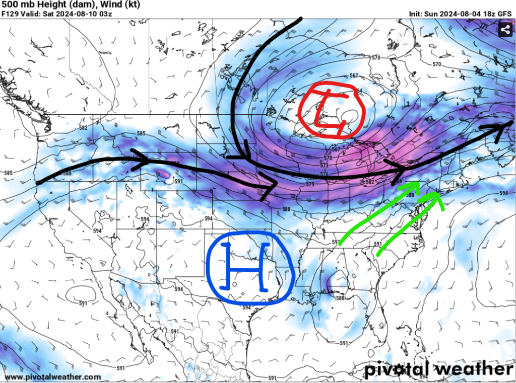
A mid-level shortwave trough will move across the Upper Midwest later this week, bringing rain chances out ahead of it and cooler temperatures on the backside.
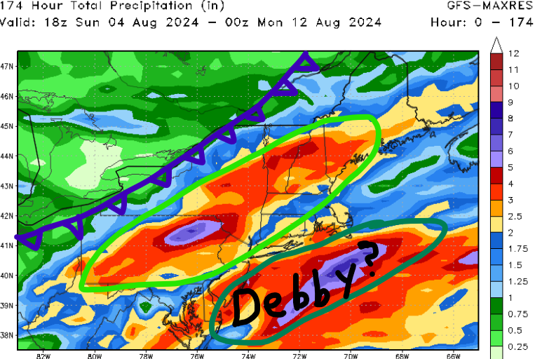
Friday evening through Saturday afternoon, warm southerly flow out ahead of the low-pressure center will help advect moisture northward into the interior northeast. A nice swath of 3-6″ of rain is possible from Pennsylvania to Maine with some localized totals over 6″.
Furthermore, we don’t know what Hurricane Debby will do after stalling in the Carolinas for a few days. Some models are bringing the storm up the East Coast which could cause flooding concerns for Baltimore, MD, Philadelphia, PA, and New York City, NY. We’ll have more confidence on this by the middle of the week.


