Happy Wednesday! We have a couple of topics to discuss as different trends are occurring nationwide. Tropical Storm Debby continues to bring historic rain and flooding to the East Coast. as it moves to the north. Extreme heat is again affecting the southeast, with most of the area stuck under heat advisories and highs in the upper 90s/lower 100s. On the opposite side of the country, wildfires continue to affect certain northwest regions (specifically Idaho/Wyoming), and there are some showers/thunderstorms in the southwest region. Let’s get into it!
EXCESSIVE RAIN/FLOODING ON THE EAST COAST:
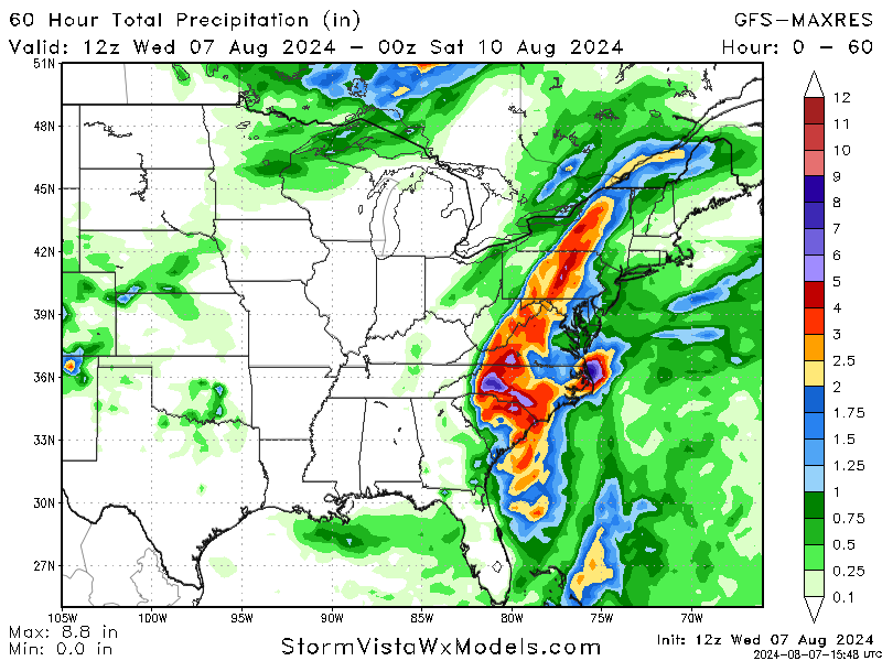

Tropical Storm Debby continues to bring huge amounts of rainfall to the eastern coast after having a big impact on Georgia and Florida. As it moves up the coast into the Northeast over the next couple of days, Debby’s impacts will keep spreading, with excessive rainfall risks along with flash and localized flooding risks.
Over the next few days, the excessive rainfall will continue to pose severe flood risks. Eastern South Carolina and southeastern North Carolina are forecasted to receive heavy rain, which could exacerbate flooding conditions. Additionally, gusty winds between 40-60 mph will impact the coastal regions. This combination of persistent heavy rain and strong winds will likely lead to further flooding, power outages, and significant disruptions.
In the Northeast region, heavy rains and thunderstorms are expected. Flood warnings are in place, with some areas facing several inches of rain. The tropical moisture from Debby and a cold front will result in severe weather and increase the risk of flash flooding. Rainfall totals of 5-8 inches are anticipated, with localized areas possibly seeing higher amounts.
Residents in the affected areas should be prepared for continued flooding and follow local advisories for safety measures. Emergency declarations have facilitated federal assistance for rescue and recovery efforts. As Tropical Storm Debby progresses, staying updated with local weather reports and heeding evacuation orders will be crucial to ensure safety.
EXTREME SOUTHEASTERN HEAT:
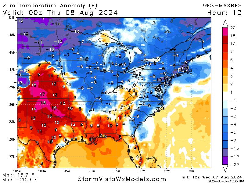

The Southeastern United States is enduring an extreme heat wave, with temperatures soaring well above average and heat indices making conditions increasingly hazardous. Over the next few days, daytime highs are expected to consistently reach the upper 90s to low 100s, with heat indices often surpassing 105°F due to high humidity. Nighttime temperatures will offer little relief, remaining in the mid to upper 70s. The region is under numerous heat advisories and warnings, indicating dangerous levels of heat that significantly increase the risk of heat-related illnesses.
Forecasts through tomorrow indicate that daytime highs will remain in the upper 90s to low 100s with mostly sunny skies and minimal cloud cover, exacerbating the heat. By this weekend, slightly lower temperatures might be observed due to possible cloud cover and isolated thunderstorms, but heat indices will still be dangerously high, around 100°F to 108°F. Moving into the start of next week, a slight cooling trend is expected, with highs in the mid to upper 90s. Despite this, high humidity will keep heat indices around 100°F to 105°F, with partly cloudy conditions and a higher chance of afternoon thunderstorms offering brief relief.
During this period, it is crucial to take precautions against heat-related illnesses, stay hydrated, wear light-colored and loose-fitting clothing, and take frequent breaks in shaded or air-conditioned areas. It is also important to keep a close eye on vulnerable populations. The extreme heat is expected to persist, with little relief in sight, making it imperative to stay updated with local weather advisories and follow safety recommendations.
IDAHO/WYOMING WILDFIRES:

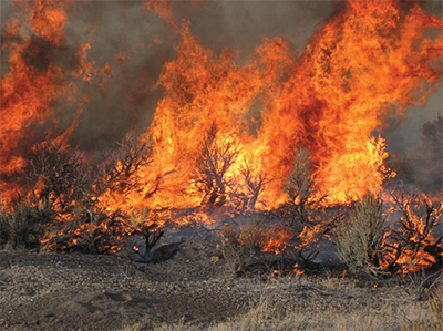
Recent lightning strikes have ignited wildfires in Idaho and Wyoming. The weather forecast for the next few days is critical for firefighting efforts. In Idaho, high temperatures are expected to reach the mid-90s, accompanied by low humidity levels, creating extremely dry conditions that can fuel the fires.
Additionally, afternoon thunderstorms are anticipated, which, although they may bring some rain, also pose the risk of lightning strikes that could ignite new fires. Winds are forecasted to be gusty, potentially reaching up to 30 mph, which can spread the existing fires rapidly and complicate containment efforts.
Similar weather patterns are expected in Wyoming, with high temperatures and low humidity dominating the forecast. Afternoon thunderstorms and gusty winds will also be present, further challenging firefighting efforts in the region. The combination of these weather conditions emphasizes the need for continuous monitoring and swift response by firefighting teams to manage wildfires effectively.
Overall, the hot, dry, and unstable weather conditions in Idaho and Wyoming are expected to persist, making it crucial for residents and authorities to remain vigilant and prepared for potential evacuations and further fire developments.


