Here is the latest from the NHC:

NOAA and Air Force Hurricane Hunters upgraded Francine to a hurricane after collecting vital data during their investigation tonight. The storm has reached an intensity of about 65 knots (75 mph), with a pressure drop to 980 mb, signaling further strengthening. Convection near the center has increased, and radar shows a developing inner core, though some dry air remains around the system.
Francine is now moving northeast at 9 knots, with a mid- to upper-level trough steering it toward the Louisiana coast, where landfall is expected by late Wednesday. After landfall, the storm will slow down and shift north-northeast over eastern Louisiana and Mississippi.
While models vary on the rate of intensification, Francine is likely to approach Category 2 strength by Wednesday morning due to warm waters and low wind shear. However, increasing wind shear and dry air are expected to limit further strengthening before landfall, with rapid weakening once inland.
KEY MESSAGES:
1. There is a danger of life-threatening storm surge on
Wednesday for the Louisiana and Mississippi coastlines, where a
Storm Surge Warning is in effect. Residents in the warning area
should follow advice, including evacuation orders, given by local
officials.
2. Damaging and life-threatening hurricane-force winds are expected
in portions of southern Louisiana on Wednesday, where a Hurricane
Warning is in effect. Preparations to protect life and property
should be complete, since tropical storm conditions are expected to
begin within this area early Wednesday.
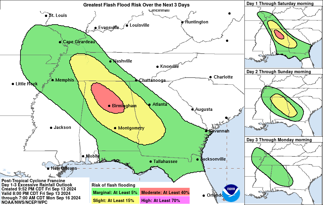
3. Francine is expected to bring heavy rainfall and the risk of
considerable flash and urban flooding across eastern Louisiana,
Mississippi, far southern Alabama and the western Florida Panhandle
through Thursday. Flash and urban flooding is probable across the
Lower Tennessee Valley and Lower Mississippi Valley Wednesday night
into Friday morning.
FORECAST POSITIONS AND MAX WINDS
INIT 11/0300Z 26.4N 94.3W 65 KT 75 MPH
12H 11/1200Z 27.7N 93.2W 80 KT 90 MPH
24H 12/0000Z 29.7N 91.4W 80 KT 90 MPH...INLAND
36H 12/1200Z 32.0N 90.2W 45 KT 50 MPH...INLAND
48H 13/0000Z 34.2N 89.9W 30 KT 35 MPH...INLAND
60H 13/1200Z 35.5N 89.9W 25 KT 30 MPH...POST-TROP/REMNT LOW
72H 14/0000Z 36.3N 89.8W 25 KT 30 MPH...POST-TROP/REMNT LOW
96H 15/0000Z...DISSIPATED
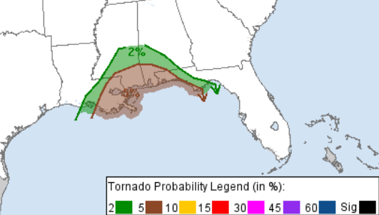
Inland, the main concern looks to be the wind, tornadoes, and heavy rain. the NHC and CPC has released a Moderate Risk for flash flooding for most of the area tomorrow and Thursday and the SPC has issued a Slight Risk for parts of the area and a Marginal Risk for other parts of the area for severe weather – mainly brief tornadoes..
On top of that, the timeline looks to have further clowed down slightly with the onset of Tropical Storm force wind across much of the area now starting now at or after 8pm.

I’ll continue to monitor model guidance and trends tomorrow morning from the overnight updates and model data.


Thanks