The latest from the NHC shows that Tropical Storm Francine is still floating around the southwestern Gulf and it is now drifting northward.

The forecast from the NHC shows the Tropical Storm strengthening into a Hurricane – now a Category 1 Hurricane – before landfall. Max sustained wind shown is 100mph.
NHC.NOAA.GOV
FORECAST POSITIONS AND MAX WINDS
INIT 11/0900Z 27.0N 93.8W 80 KT 90 MPH
12H 11/1800Z 28.5N 92.3W 85 KT 100 MPH
24H 12/0600Z 30.6N 90.8W 50 KT 60 MPH…INLAND
36H 12/1800Z 33.0N 90.1W 30 KT 35 MPH…INLAND
48H 13/0600Z 34.7N 90.3W 25 KT 30 MPH…POST-TROP/EXTRATROP
60H 13/1800Z 35.3N 90.3W 20 KT 25 MPH…POST-TROP/EXTRATROP
72H 14/0600Z…DISSIPATED
Landfall is expect to happen on Wednesday afternoon / evening.
The timeline on the arrival of Tropical Storm-force wind is shown in the graphic below on the left and the percent-chance you see Hurricane-force winds is below and on the right. Notice the Hurricane-force winds are confined mainly to the immediate coastline.

Below is the county-by-county breakdown. The storm is still strengthening, there is a chance this forecast will change. So please take this for now, but check back for an update.
Given the timeline above, please note that all times shown begin on Wednesday and – if needed – move into Thursday morning.
QUICK NOTES
As we talked about last night, the dry air – and a little shear – are going to do a number on this thing as it nears landfall and once it is ashore. That should reduce the length of the impacts, but won’t really change the potency of the system for folks with impacts that start before, roughly 2am overnight tonight.
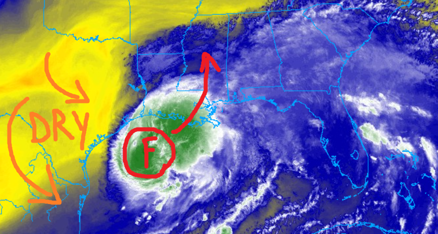
So if you live south of – roughly – Highway 84 the forecast has actually shifted slightly slower, but your wind has increased slightly for a the short period of time where the most intense part of the storm is passing.
For folks north of HWY 84 the forecast has slowed and your wind has also slowed.
The insertion of dry air and shear may also increase the tornado along some of the souter bands in the back right quadrant, too. So the tornado risk may linger for some a bit longer than “normal” during a landfalling tropical system.
The good news is the erosion of the back half of the storm as it moves ashore means that the rainfall totals ahve been reduce for many spots.
I know this may feel like a stressful situation, but I promise you that if you take the right steps, have a plan in place, and execute that plan, you’ll make it through the storm with far less stress.
Along I-20
Rankin County:
3p — 11p – As things get started, a few isolated storms are possible. Sustained wind between 15 and 30mph. A few may be severe. The main concerns are brief heavy rain, some lightning, gusty wind, small hail. Rainfall totals up to 1 inch possible.
11p — 8a – Sustained wind between 25 and 40 mph. There is a chance for showers and storms. Some severe. the main concerns are heavy rain, wind gusts up to 60mph, and a few tornadoes (up to EF1 in strength). Rainfall totals are estimated to be around 3-6 inches.
8a — 12p – All Clear! Though, there is a chance for some lingering brief heavy rain, some lightning, gusty wind, small hail. Rainfall totals up to 1 inch possible.
How it will impact you:
— Roads may be briefly impassable due to short-term flash flooding
— Trees may be knocked down, and scattered power outages are likely
— A Tornado Watch is possible
Best to be where you want to be by 10p
Scott County:
3p — 11p – As things get started, a few isolated storms are possible. Sustained wind between 15 and 30mph. A few may be severe. The main concerns are brief heavy rain, some lightning, gusty wind, small hail. Rainfall totals up to 1 inch possible.
11p — 8a – Sustained wind between 25 and 40 mph. There is a chance for showers and storms. Some severe. the main concerns are heavy rain, wind gusts up to 60mph, and a few tornadoes (up to EF1 in strength). Rainfall totals are estimated to be around 3-6 inches.
8a — 12p – All Clear! Though, there is a chance for some lingering brief heavy rain, some lightning, gusty wind, small hail. Rainfall totals up to 1 inch possible.
How it will impact you:
— Roads may be briefly impassable due to short-term flash flooding
— Trees may be knocked down, and scattered power outages are likely
— A Tornado Watch is possible
Best to be where you want to be by 10p
Newton County:
3p — 11p – As things get started, a few isolated storms are possible. Sustained wind between 15 and 30mph. A few may be severe. The main concerns are brief heavy rain, some lightning, gusty wind, small hail. Rainfall totals up to 1 inch possible.
11p — 8a – Sustained wind between 25 and 40 mph. There is a chance for showers and storms. Some severe. the main concerns are heavy rain, wind gusts up to 60mph, and a few tornadoes (up to EF1 in strength). Rainfall totals are estimated to be around 3-6 inches.
8a — 12p – All Clear! Though, there is a chance for some lingering brief heavy rain, some lightning, gusty wind, small hail. Rainfall totals up to 1 inch possible.
How it will impact you:
— Roads may be briefly impassable due to short-term flash flooding
— Trees may be knocked down, and scattered power outages are likely
— A Tornado Watch is possible
Best to be where you want to be by 10p
Lauderdale County:
3p — 11p – As things get started, a few isolated storms are possible. Sustained wind between 15 and 30mph. A few may be severe. The main concerns are brief heavy rain, some lightning, gusty wind, small hail. Rainfall totals up to 1 inch possible.
11p — 8a – Sustained wind between 30 and 40 mph. There is a chance for showers and storms. Some severe. the main concerns are heavy rain, wind gusts up to 60mph, and a few tornadoes (up to EF1 in strength). Rainfall totals are estimated to be around 3-6 inches.
8a — 12p – All Clear! Though, there is a chance for some lingering brief heavy rain, some lightning, gusty wind, small hail. Rainfall totals up to 1 inch possible.
How it will impact you:
— Roads may be briefly impassable due to short-term flash flooding
— Trees may be knocked down, and scattered power outages are likely
— A Tornado Watch is possible
Best to be where you want to be by 10p
Near I-20
Copiah County:
3p — 10p – As things get started, a few isolated storms are possible. Sustained wind between 15 and 30mph. A few may be severe. The main concerns are brief heavy rain, some lightning, gusty wind, small hail. Rainfall totals up to 1 inch possible.
10p — 7a – Sustained wind between 35 and 40 mph. There is a chance for showers and storms. Some severe. the main concerns are heavy rain, wind gusts up to 60mph, and a few tornadoes (up to EF1 in strength). Rainfall totals are estimated to be around 3-6 inches.
7a — 12p – All Clear! Though, there is a chance for some lingering brief heavy rain, some lightning, gusty wind, small hail. Rainfall totals up to 1 inch possible.
How it will impact you:
— Roads may be briefly impassable due to short-term flash flooding
— Trees may be knocked down, and scattered power outages are likely
— A Tornado Watch is possible
Best to be where you want to be by 9p
Simpson County:
3p — 10p – As things get started, a few isolated storms are possible. Sustained wind between 15 and 30mph. A few may be severe. The main concerns are brief heavy rain, some lightning, gusty wind, small hail. Rainfall totals up to 1 inch possible.
10p — 7a – Sustained wind between 35 and 40 mph. There is a chance for showers and storms. Some severe. the main concerns are heavy rain, wind gusts up to 60mph, and a few tornadoes (up to EF1 in strength). Rainfall totals are estimated to be around 3-6 inches.
7a — 12p – All Clear! Though, there is a chance for some lingering brief heavy rain, some lightning, gusty wind, small hail. Rainfall totals up to 1 inch possible.
How it will impact you:
— Roads may be briefly impassable due to short-term flash flooding
— Trees may be knocked down, and scattered power outages are likely
— A Tornado Watch is possible
Best to be where you want to be by 9p
Smith County:
3p — 10p – As things get started, a few isolated storms are possible. Sustained wind between 15 and 30mph. A few may be severe. The main concerns are brief heavy rain, some lightning, gusty wind, small hail. Rainfall totals up to 1 inch possible.
10p — 7a – Sustained wind between 35 and 45 mph. There is a chance for showers and storms. Some severe. the main concerns are heavy rain, wind gusts up to 65mph, and a few tornadoes (up to EF1 in strength). Rainfall totals are estimated to be around 3-6 inches.
7a — 12p – All Clear! Though, there is a chance for some lingering brief heavy rain, some lightning, gusty wind, small hail. Rainfall totals up to 1 inch possible.
How it will impact you:
— Roads may be briefly impassable due to short-term flash flooding
— Trees may be knocked down, and scattered power outages are likely
— A Tornado Watch is possible
Best to be where you want to be by 9p
Jasper County:
3p — 10p – As things get started, a few isolated storms are possible. Sustained wind between 15 and 30mph. A few may be severe. The main concerns are brief heavy rain, some lightning, gusty wind, small hail. Rainfall totals up to 1 inch possible.
10p — 7a – Sustained wind between 35 and 45 mph. There is a chance for showers and storms. Some severe. the main concerns are heavy rain, wind gusts up to 65mph, and a few tornadoes (up to EF1 in strength). Rainfall totals are estimated to be around 3-6 inches.
7a — 12p – All Clear! Though, there is a chance for some lingering brief heavy rain, some lightning, gusty wind, small hail. Rainfall totals up to 1 inch possible.
How it will impact you:
— Roads may be briefly impassable due to short-term flash flooding
— Trees may be knocked down, and scattered power outages are likely
— A Tornado Watch is possible
Best to be where you want to be by 9p
Clarke County:
3p — 10p – As things get started, a few isolated storms are possible. Sustained wind between 15 and 30mph. A few may be severe. The main concerns are brief heavy rain, some lightning, gusty wind, small hail. Rainfall totals up to 1 inch possible.
10p — 7a – Sustained wind between 30 and 40 mph. There is a chance for showers and storms. Some severe. the main concerns are heavy rain, wind gusts up to 55mph, and a few tornadoes (up to EF1 in strength). Rainfall totals are estimated to be around 3-5 inches.
7a — 12p – All Clear! Though, there is a chance for some lingering brief heavy rain, some lightning, gusty wind, small hail. Rainfall totals up to 1 inch possible.
How it will impact you:
— Roads may be briefly impassable due to short-term flash flooding
— Trees may be knocked down, and scattered power outages are likely
— A Tornado Watch is possible
Best to be where you want to be by 9p
HWY 84 Corridor
Lincoln County:
1p — 8p – Sustained wind will be between 15 and 35mph. As things get started, a few isolated storms are possible. A few may be severe. The main concerns are brief heavy rain, some lightning, gusty wind, small hail. Rainfall totals up to 1 inch possible.
8p — 4a – Sustained wind will be between 30 and 50mph for up to an hour as most intense part of the storm passes. There is a chance for showers and storms. Some severe. the main concerns are heavy rain, wind gusts up to 65mph, and a few tornadoes (up to EF2 in strength). Rainfall totals are estimated to be around 4-7 inches.
4a — 10a – All Clear! Though, there is a chance for some lingering brief heavy rain, some lightning, gusty wind. Rainfall totals up to 1 inch possible.
How it will impact you:
— Roads may be briefly impassable due to short-term flash flooding
— Roads may be impassable due to downed trees
— Numerous power outages are likely, have battery backup if needed
— A Tornado Watch is possible
Best to be where you want to be by 7p
Lawrence County:
1p — 8p – Sustained wind will be between 15 and 35mph. As things get started, a few isolated storms are possible. A few may be severe. The main concerns are brief heavy rain, some lightning, gusty wind, small hail. Rainfall totals up to 1 inch possible.
8p — 4a – Sustained wind will be between 30 and 50mph for up to an hour as most intense part of the storm passes. There is a chance for showers and storms. Some severe. the main concerns are heavy rain, wind gusts up to 65mph, and a few tornadoes (up to EF2 in strength). Rainfall totals are estimated to be around 4-7 inches.
4a — 10a – All Clear! Though, there is a chance for some lingering brief heavy rain, some lightning, gusty wind. Rainfall totals up to 1 inch possible.
How it will impact you:
— Roads may be briefly impassable due to short-term flash flooding
— Roads may be impassable due to downed trees
— Numerous power outages are likely, have battery backup if needed
— A Tornado Watch is possible
Best to be where you want to be by 7p
Jeff Davis County:
1p — 8p – Sustained wind will be between 15 and 35mph. As things get started, a few isolated storms are possible. A few may be severe. The main concerns are brief heavy rain, some lightning, gusty wind, small hail. Rainfall totals up to 1 inch possible.
8p — 4a – Sustained wind will be between 30 and 50mph for up to an hour as most intense part of the storm passes. There is a chance for showers and storms. Some severe. the main concerns are heavy rain, wind gusts up to 65mph, and a few tornadoes (up to EF2 in strength). Rainfall totals are estimated to be around 4-7 inches.
4a — 10a – All Clear! Though, there is a chance for some lingering brief heavy rain, some lightning, gusty wind. Rainfall totals up to 1 inch possible.
How it will impact you:
— Roads may be briefly impassable due to short-term flash flooding
— Roads may be impassable due to downed trees
— Numerous power outages are likely, have battery backup if needed
— A Tornado Watch is possible
Best to be where you want to be by 7p
Covington County:
1p — 8p – Sustained wind will be between 15 and 35mph. As things get started, a few isolated storms are possible. A few may be severe. The main concerns are brief heavy rain, some lightning, gusty wind, small hail. Rainfall totals up to 1 inch possible.
8p — 4a – Sustained wind will be between 30 and 50mph for up to an hour as most intense part of the storm passes. There is a chance for showers and storms. Some severe. the main concerns are heavy rain, wind gusts up to 65mph, and a few tornadoes (up to EF2 in strength). Rainfall totals are estimated to be around 4-7 inches.
4a — 10a – All Clear! Though, there is a chance for some lingering brief heavy rain, some lightning, gusty wind. Rainfall totals up to 1 inch possible.
How it will impact you:
— Roads may be briefly impassable due to short-term flash flooding
— Roads may be impassable due to downed trees
— Numerous power outages are likely, have battery backup if needed
— A Tornado Watch is possible
Best to be where you want to be by 7p
Jones County:
1p — 8p – Sustained wind will be between 15 and 35mph. As things get started, a few isolated storms are possible. A few may be severe. The main concerns are brief heavy rain, some lightning, gusty wind, small hail. Rainfall totals up to 1 inch possible.
8p — 4a – Sustained wind will be between 30 and 50mph for up to an hour as most intense part of the storm passes. There is a chance for showers and storms. Some severe. the main concerns are heavy rain, wind gusts up to 65mph, and a few tornadoes (up to EF2 in strength). Rainfall totals are estimated to be around 4-7 inches.
4a — 10a – All Clear! Though, there is a chance for some lingering brief heavy rain, some lightning, gusty wind. Rainfall totals up to 1 inch possible.
How it will impact you:
— Roads may be briefly impassable due to short-term flash flooding
— Roads may be impassable due to downed trees
— Numerous power outages are likely, have battery backup if needed
— A Tornado Watch is possible
Best to be where you want to be by 7p
Wayne County:
1p — 8p – Sustained wind will be between 15 and 35mph. As things get started, a few isolated storms are possible. A few may be severe. The main concerns are brief heavy rain, some lightning, gusty wind, small hail. Rainfall totals up to 1 inch possible.
8p — 4a – Sustained wind will be between 30 and 45mph for up to an hour as most intense part of the storm passes. There is a chance for showers and storms. Some severe. the main concerns are heavy rain, wind gusts up to 60mph, and a few tornadoes (up to EF2 in strength). Rainfall totals are estimated to be around 4-7 inches.
4a — 10a – All Clear! Though, there is a chance for some lingering brief heavy rain, some lightning, gusty wind. Rainfall totals up to 1 inch possible.
How it will impact you:
— Roads may be briefly impassable due to short-term flash flooding
— Roads may be impassable due to downed trees
— Numerous power outages are likely, have battery backup if needed
— A Tornado Watch is possible
Best to be where you want to be by 7p
HWY 98 Corridor
Pike County:
9a — 5p – As things get started, a few isolated storms are possible. A few may be severe. The main concerns are brief heavy rain, some lightning, gusty wind, small hail. Rainfall totals up to 1-2 inches possible.
5p — 4a – There is a chance for showers and storms. Some severe. Wind will be intense with sustained wind up to 55mph for up to an hour as the strongest part of the core passes. The main concerns are heavy rain, wind gusts up to 65mph, and a few tornadoes (up to EF2 in strength). Rainfall totals are estimated to be around 5-9 inches.
4a — 10a – All Clear! Though, there is a chance for some lingering brief heavy rain, some lightning, gusty wind. Rainfall totals up to 1 inch possible.
How it will impact you:
— Roads may be briefly impassable due to short-term flash flooding
— Wind will knock over and blow around anything not tied down or anchored
— Roads may be impassable due to downed trees
— Numerous, multiple-hour, power outages are likely, have battery backup
— A Tornado Watch is likely
Best to be where you want to be by 4p
Walthall County:
9a — 5p – As things get started, a few isolated storms are possible. A few may be severe. The main concerns are brief heavy rain, some lightning, gusty wind, small hail. Rainfall totals up to 1-2 inches possible.
5p — 4a – There is a chance for showers and storms. Some severe. Wind will be intense with sustained wind up to 55mph for up to an hour as the strongest part of the core passes. The main concerns are heavy rain, wind gusts up to 65mph, and a few tornadoes (up to EF2 in strength). Rainfall totals are estimated to be around 5-9 inches.
4a — 10a – All Clear! Though, there is a chance for some lingering brief heavy rain, some lightning, gusty wind. Rainfall totals up to 1 inch possible.
How it will impact you:
— Roads may be briefly impassable due to short-term flash flooding
— Wind will knock over and blow around anything not tied down or anchored
— Roads may be impassable due to downed trees
— Numerous, multiple-hour, power outages are likely, have battery backup
— A Tornado Watch is likely
Best to be where you want to be by 4p
Marion County:
9a — 5p – As things get started, a few isolated storms are possible. A few may be severe. The main concerns are brief heavy rain, some lightning, gusty wind, small hail. Rainfall totals up to 1-2 inches possible.
5p — 4a – There is a chance for showers and storms. Some severe. Wind will be intense with sustained wind up to 55mph for up to an hour as the strongest part of the core passes. The main concerns are heavy rain, wind gusts up to 65mph, and a few tornadoes (up to EF2 in strength). Rainfall totals are estimated to be around 5-9 inches.
4a — 10a – All Clear! Though, there is a chance for some lingering brief heavy rain, some lightning, gusty wind. Rainfall totals up to 1 inch possible.
How it will impact you:
— Roads may be briefly impassable due to short-term flash flooding
— Wind will knock over and blow around anything not tied down or anchored
— Roads may be impassable due to downed trees
— Numerous, multiple-hour, power outages are likely, have battery backup
— A Tornado Watch is likely
Best to be where you want to be by 4p
Lamar County:
9a — 5p – As things get started, a few isolated storms are possible. A few may be severe. The main concerns are brief heavy rain, some lightning, gusty wind, small hail. Rainfall totals up to 1-2 inches possible.
5p — 4a – There is a chance for showers and storms. Some severe. Wind will be intense with sustained wind up to 50mph for up to an hour as the strongest part of the core passes. The main concerns are heavy rain, wind gusts up to 65mph, and a few tornadoes (up to EF2 in strength). Rainfall totals are estimated to be around 5-9 inches.
4a — 10a – All Clear! Though, there is a chance for some lingering brief heavy rain, some lightning, gusty wind. Rainfall totals up to 1 inch possible.
How it will impact you:
— Roads may be briefly impassable due to short-term flash flooding
— Wind will knock over and blow around anything not tied down or anchored
— Roads may be impassable due to downed trees
— Numerous, multiple-hour, power outages are likely, have battery backup
— A Tornado Watch is likely
Best to be where you want to be by 4p
Forrest County:
9a — 5p – As things get started, a few isolated storms are possible. A few may be severe. The main concerns are brief heavy rain, some lightning, gusty wind, small hail. Rainfall totals up to 1-2 inches possible.
5p — 4a – There is a chance for showers and storms. Some severe. Wind will be intense with sustained wind up to 50mph for up to an hour as the strongest part of the core passes. The main concerns are heavy rain, wind gusts up to 65mph, and a few tornadoes (up to EF2 in strength). Rainfall totals are estimated to be around 5-8 inches.
4a — 10a – All Clear! Though, there is a chance for some lingering brief heavy rain, some lightning, gusty wind. Rainfall totals up to 1 inch possible.
How it will impact you:
— Roads may be briefly impassable due to short-term flash flooding
— Wind will knock over and blow around anything not tied down or anchored
— Roads may be impassable due to downed trees
— Numerous, multiple-hour, power outages are likely, have battery backup
— A Tornado Watch is likely
Best to be where you want to be by 4p
Perry County:
9a — 5p – As things get started, a few isolated storms are possible. A few may be severe. The main concerns are brief heavy rain, some lightning, gusty wind, small hail. Rainfall totals up to 1-2 inches possible.
5p — 4a – There is a chance for showers and storms. Some severe. Wind will be intense with sustained wind up to 50mph for up to an hour as the strongest part of the core passes. The main concerns are heavy rain, wind gusts up to 65mph, and a few tornadoes (up to EF2 in strength). Rainfall totals are estimated to be around 4-7 inches.
4a — 10a – All Clear! Though, there is a chance for some lingering brief heavy rain, some lightning, gusty wind. Rainfall totals up to 1 inch possible.
How it will impact you:
— Roads may be briefly impassable due to short-term flash flooding
— Wind will knock over and blow around anything not tied down or anchored
— Roads may be impassable due to downed trees
— Numerous, multiple-hour, power outages are likely, have battery backup
— A Tornado Watch is likely
Best to be where you want to be by 4p
Greene County:
9a — 5p – As things get started, a few isolated storms are possible. A few may be severe. The main concerns are brief heavy rain, some lightning, gusty wind, small hail. Rainfall totals up to 1-2 inches possible.
5p — 4a – There is a chance for showers and storms. Some severe. Wind will be intense with sustained wind up to 40mph for up to an hour as the strongest part of the core passes. The main concerns are heavy rain, wind gusts up to 65mph, and a few tornadoes (up to EF2 in strength). Rainfall totals are estimated to be around 3-6 inches.
4a — 10a – All Clear! Though, there is a chance for some lingering brief heavy rain, some lightning, gusty wind. Rainfall totals up to 1 inch possible.
How it will impact you:
— Roads may be briefly impassable due to short-term flash flooding
— Wind will knock over and blow around anything not tied down or anchored
— Roads may be impassable due to downed trees
— Numerous, multiple-hour, power outages are likely, have battery backup
— A Tornado Watch is likely
Best to be where you want to be by 4p
HWY 26 Corridor
Pearl River County:
8a — 4p – As things get started, a few isolated storms are possible. A few may be severe. The main concerns are brief heavy rain, some lightning, gusty wind, small hail. Rainfall totals up to 1-2 inches possible.
4p — 2a – There is a chance for showers and storms. Some severe. Wind will be intense with sustained wind up to 60mph for up to an hour as the strongest part of the core passes. The main concerns are heavy rain, wind gusts up to 65mph, and a few tornadoes (up to EF2 in strength). Rainfall totals are estimated to be around 4-8 inches.
2a — 6a – All Clear! Though, there is a chance for some lingering brief heavy rain, some lightning, gusty wind. Rainfall totals up to 1 inch possible.
How it will impact you:
— Roads may be briefly impassable due to short-term flash flooding
— Wind will knock over and blow around anything not tied down or anchored
— Roads may be impassable due to downed trees
— Numerous, multiple-hour, power outages are likely, have battery backup
— A Tornado Watch is likely
Best to be where you want to be by 4p
Stone County:
9a — 5p – As things get started, a few isolated storms are possible. A few may be severe. The main concerns are brief heavy rain, some lightning, gusty wind, small hail. Rainfall totals up to 1 inch possible.
5p — 3a – There is a chance for showers and storms. Some severe. The main concerns are heavy rain, wind gusts up to 60mph, and a few tornadoes (up to EF1 in strength). Rainfall totals are estimated to be around 4-7 inches.
3a — 7a – All Clear! Though, there is a chance for some lingering brief heavy rain, some lightning, gusty wind. Rainfall totals up to 1 inch possible.
How it will impact you:
— Roads may be briefly impassable due to short-term flash flooding
— Wind will knock over and blow around anything not tied down or anchored
— Roads may be impassable due to downed trees
— Numerous, multiple-hour, power outages are likely, have battery backup
— A Tornado Watch is likely
Best to be where you want to be by 4p
George County:
10a — 5p – As things get started, a few isolated storms are possible. A few may be severe. The main concerns are brief heavy rain, some lightning, gusty wind, small hail. Rainfall totals up to 1 inch possible.
5p — 4a – There is a chance for showers and storms. Some severe. the main concerns are heavy rain, wind gusts up to 55mph, and a few tornadoes (up to EF1 in strength). Rainfall totals are estimated to be around 4-7 inches.
4a — 8a – All Clear! Though, there is a chance for some lingering brief heavy rain, some lightning, gusty wind. Rainfall totals up to 1 inch possible.
How it will impact you:
— Roads may be briefly impassable due to short-term flash flooding
— Wind will knock over and blow around anything not tied down or anchored
— Roads may be impassable due to downed trees
— Numerous, multiple-hour, power outages are likely, have battery backup
— A Tornado Watch is likely
Best to be where you want to be by 4p
MISSISSIPPI COAST
Hancock County:
8a — 2p – As things get started, a few isolated storms are possible. A few may be severe. The main concerns are brief heavy rain, some lightning, gusty wind, small hail. Rainfall totals up to 1 inch possible.
2p — 12a – There is a chance for showers and storms. Some severe. Wind will be intense with sustained wind up to 70mph for up to an hour as the strongest part of the core passes. The main concerns are heavy rain, wind gusts up to 75mph, and a few tornadoes (up to EF2 in strength). Rainfall totals are estimated to be around 4-7 inches.
12a — 3a – All Clear! Though, there is a chance for some lingering brief heavy rain, some lightning, gusty wind. Rainfall totals up to 1 inch possible.
How it will impact you:
— Roads may be briefly impassable due to short-term flash flooding
— Wind will knock over and blow around anything not tied down or anchored
— Roads may be impassable due to downed trees
— Numerous, multiple-hour, power outages are likely, have battery backup
— A Tornado Watch is likely
–Peak Storm Surge of 3-5ft
Best to be where you want to be by 1p
Harrison County:
8a — 3p – As things get started, a few isolated storms are possible. A few may be severe. The main concerns are brief heavy rain, some lightning, gusty wind, small hail. Rainfall totals up to 1 inch possible.
3p — 1a – There is a chance for showers and storms. Some severe. the main concerns are heavy rain, wind gusts up to 70mph, and a few tornadoes (up to EF2 in strength). Rainfall totals are estimated to be around 4-7 inches.
1a — 4a – All Clear! Though, there is a chance for some lingering brief heavy rain, some lightning, gusty wind. Rainfall totals up to 1 inch possible.
How it will impact you:
— Roads may be briefly impassable due to short-term flash flooding
— Wind will knock over and blow around anything not tied down or anchored
— Roads may be impassable due to downed trees
— Numerous, multiple-hour, power outages are likely, have battery backup
— A Tornado Watch is likely
–Peak Storm Surge of 3-5ft
Best to be where you want to be by 2p
Jackson County:
8a — 3p – As things get started, a few isolated storms are possible. A few may be severe. The main concerns are brief heavy rain, some lightning, gusty wind, small hail. Rainfall totals up to 1 inch possible.
3p — 1a – There is a chance for showers and storms. Some severe. the main concerns are heavy rain, wind gusts up to 65mph, and a few tornadoes (up to EF1 in strength). Rainfall totals are estimated to be around 4-7 inches.
1a — 4a – All Clear! Though, there is a chance for some lingering brief heavy rain, some lightning, gusty wind. Rainfall totals up to 1 inch possible.
How it will impact you:
— Roads may be briefly impassable due to short-term flash flooding
— Wind will knock over and blow around anything not tied down or anchored
— Roads may be impassable due to downed trees
— Numerous, multiple-hour, power outages are likely, have battery backup
— A Tornado Watch is possible
–Peak Storm Surge of 2-4ft
Best to be where you want to be by 2p
LOUISIANA PARISHES
St. Helena Parish:
8a — 2p – As things get started, a few isolated storms are possible. A few may be severe. The main concerns are brief heavy rain, some lightning, gusty wind, small hail. Rainfall totals up to 1-3 inches possible.
2p — 12a – There is a chance for showers and storms. Wind will be intense with sustained wind up to 55mph for up to an hour as the strongest part of the core passes. Some severe. the main concerns are heavy rain, wind gusts up to 80mph, and a few tornadoes (up to EF2 in strength). Rainfall totals are estimated to be around 5-10 inches.
12a — 3a – All Clear! Though, there is a chance for some lingering brief heavy rain, some lightning, gusty wind. Rainfall totals up to 1 inch possible.
How it will impact you:
— Roads may be briefly impassable due to short-term flash flooding
— Wind will knock over and blow around anything not tied down or anchored
— Roads may be impassable due to downed trees
— Numerous, multiple-hour, power outages are likely, have battery backup
— A Tornado Watch is likely
Best to be where you want to be by 1p
Tangipahoa Parish:
8a — 2p – As things get started, a few isolated storms are possible. A few may be severe. The main concerns are brief heavy rain, some lightning, gusty wind, small hail. Rainfall totals up to 1-3 inches possible.
2p — 12a – There is a chance for showers and storms. Wind will be intense with sustained wind up to 65mph for up to an hour as the strongest part of the core passes. Some severe. the main concerns are heavy rain, wind gusts up to 85mph, and a few tornadoes (up to EF2 in strength). Rainfall totals are estimated to be around 5-10 inches.
12a — 3a – All Clear! Though, there is a chance for some lingering brief heavy rain, some lightning, gusty wind. Rainfall totals up to 1 inch possible.
How it will impact you:
— Roads may be briefly impassable due to short-term flash flooding
— Wind will knock over and blow around anything not tied down or anchored
— Roads may be impassable due to downed trees
— Numerous, multiple-hour, power outages are likely, have battery backup
— A Tornado Watch is likely
Best to be where you want to be by 1p
Washington Parish:
8a — 2p – As things get started, a few isolated storms are possible. A few may be severe. The main concerns are brief heavy rain, some lightning, gusty wind, small hail. Rainfall totals up to 1-3 inches possible.
2p — 12a – There is a chance for showers and storms. Wind will be intense with sustained wind up to 65mph for up to an hour as the strongest part of the core passes. Some severe. the main concerns are heavy rain, wind gusts up to 85mph, and a few tornadoes (up to EF2 in strength). Rainfall totals are estimated to be around 5-10 inches.
12a — 3a – All Clear! Though, there is a chance for some lingering brief heavy rain, some lightning, gusty wind. Rainfall totals up to 1 inch possible.
How it will impact you:
— Roads may be briefly impassable due to short-term flash flooding
— Wind will knock over and blow around anything not tied down or anchored
— Roads may be impassable due to downed trees
— Numerous, multiple-hour, power outages are likely, have battery backup
— A Tornado Watch is likely
Best to be where you want to be by 1p
Livingston Parish:
8a — 2p – As things get started, a few isolated storms are possible. A few may be severe. The main concerns are brief heavy rain, some lightning, gusty wind, small hail. Rainfall totals up to 1-3 inches possible.
2p — 12a – There is a chance for showers and storms. Wind will be intense with sustained wind up to 65mph for up to an hour as the strongest part of the core passes. Some severe. the main concerns are heavy rain, wind gusts up to 85mph, and a few tornadoes (up to EF2 in strength). Rainfall totals are estimated to be around 6-12 inches.
12a — 3a – All Clear! Though, there is a chance for some lingering brief heavy rain, some lightning, gusty wind. Rainfall totals up to 1 inch possible.
How it will impact you:
— Roads may be briefly impassable due to short-term flash flooding
— Wind will knock over and blow around anything not tied down or anchored
— Roads may be impassable due to downed trees
— Numerous, multiple-hour, power outages are likely, have battery backup
— A Tornado Watch is likely
Best to be where you want to be by 1p
St. Tammany Parish:
8a — 2p – As things get started, a few isolated storms are possible. A few may be severe. The main concerns are brief heavy rain, some lightning, gusty wind, small hail. Rainfall totals up to 1-3 inches possible.
2p — 12a – There is a chance for showers and storms. Wind will be intense with sustained wind up to 65mph for up to an hour as the strongest part of the core passes. Some severe. the main concerns are heavy rain, wind gusts up to 85mph, and a few tornadoes (up to EF2 in strength). Rainfall totals are estimated to be around 5-10 inches.
12a — 3a – All Clear! Though, there is a chance for some lingering brief heavy rain, some lightning, gusty wind. Rainfall totals up to 1 inch possible.
How it will impact you:
— Roads may be briefly impassable due to short-term flash flooding
— Wind will knock over and blow around anything not tied down or anchored
— Roads may be impassable due to downed trees
— Numerous, multiple-hour, power outages are likely, have battery backup
— A Tornado Watch is likely
Best to be where you want to be by 1p
Orleans Parish:
8a — 1p – As things get started, a few isolated storms are possible. A few may be severe. The main concerns are brief heavy rain, some lightning, gusty wind, small hail. Rainfall totals up to 1-3 inches possible.
1p — 11p – There is a chance for showers and storms. Wind will be intense with sustained wind up to 70mph for up to an hour as the strongest part of the core passes. Some severe. the main concerns are heavy rain, wind gusts up to 90mph, and a few tornadoes (up to EF2 in strength). Rainfall totals are estimated to be around 5-10 inches.
11p — 3a – All Clear! Though, there is a chance for some lingering brief heavy rain, some lightning, gusty wind. Rainfall totals up to 1 inch possible.
How it will impact you:
— Roads may be briefly impassable due to short-term flash flooding
— Wind will knock over and blow around anything not tied down or anchored
— Roads may be impassable due to downed trees
— Numerous, multiple-hour, power outages are likely, have battery backup
— A Tornado Watch is likely
Best to be where you want to be by 1p
ALABAMA COUNTIES
Sumter County:
11a — 7p – As things get started, a few isolated storms are possible. A few may be severe. The main concerns are brief heavy rain, some lightning, gusty wind, small hail. Rainfall totals up to 1 inch possible.
7p — 7a – There is a chance for showers and storms. Some severe. the main concerns are heavy rain, wind gusts up to 45mph, and a few tornadoes (up to EF1 in strength). Rainfall totals are estimated to be around 3-5 inches.
7a — 1p – All Clear! Though, there is a chance for some lingering brief heavy rain, some lightning, gusty wind, small hail. Rainfall totals up to 1 inch possible.
How it will impact you:
— Roads may be briefly impassable due to short-term flash flooding
— Trees may be knocked down, and some power outages are possible
— A Tornado Watch is possible
Best to be where you want to be by 6p
Choctaw County:
11a — 7p – As things get started, a few isolated storms are possible. A few may be severe. The main concerns are brief heavy rain, some lightning, gusty wind, small hail. Rainfall totals up to 1 inch possible.
7p — 7a – There is a chance for showers and storms. Some severe. the main concerns are heavy rain, wind gusts up to 45mph, and a few tornadoes (up to EF1 in strength). Rainfall totals are estimated to be around 3-5 inches.
7a — 1p – All Clear! Though, there is a chance for some lingering brief heavy rain, some lightning, gusty wind, small hail. Rainfall totals up to 1 inch possible.
How it will impact you:
— Roads may be briefly impassable due to short-term flash flooding
— Trees may be knocked down, and some power outages are possible
— A Tornado Watch is possible
Best to be where you want to be by 6p
Washington County:
11a — 6p – As things get started, a few isolated storms are possible. A few may be severe. The main concerns are brief heavy rain, some lightning, gusty wind, small hail. Rainfall totals up to 1 inch possible.
6p — 6a – There is a chance for showers and storms. Some severe. the main concerns are heavy rain, wind gusts up to 50mph, and a few tornadoes (up to EF1 in strength). Rainfall totals are estimated to be around 3-5 inches.
6a — 11a – All Clear! Though, there is a chance for some lingering brief heavy rain, some lightning, gusty wind, small hail. Rainfall totals up to 1 inch possible.
How it will impact you:
— Roads may be briefly impassable due to short-term flash flooding
— Trees may be knocked down, and some power outages are possible
— A Tornado Watch is possible
Best to be where you want to be by 6p
Mobile County:
11a — 6p – As things get started, a few isolated storms are possible. A few may be severe. The main concerns are brief heavy rain, some lightning, gusty wind, small hail. Rainfall totals up to 1 inch possible.
6p — 6a – There is a chance for showers and storms. Some severe. the main concerns are heavy rain, wind gusts up to 55mph, and a few tornadoes (up to EF1 in strength). Rainfall totals are estimated to be around 3-5 inches.
6a — 11a – All Clear! Though, there is a chance for some lingering brief heavy rain, some lightning, gusty wind, small hail. Rainfall totals up to 1 inch possible.
How it will impact you:
— Roads may be briefly impassable due to short-term flash flooding
— Trees may be knocked down, and some power outages are possible
— A Tornado Watch is possible
Best to be where you want to be by 6p
MISC REQUESTED COUNTIES
Neshoba County, MS:
3p — 11p – As things get started, a few isolated storms are possible. Sustained wind between 15 and 30mph. A few may be severe. The main concerns are brief heavy rain, some lightning, gusty wind, small hail. Rainfall totals up to 1 inch possible.
11p — 8a – Sustained wind between 25 and 40 mph. There is a chance for showers and storms. Some severe. the main concerns are heavy rain, wind gusts up to 60mph, and a few tornadoes (up to EF1 in strength). Rainfall totals are estimated to be around 3-6 inches.
8a — 12p – All Clear! Though, there is a chance for some lingering brief heavy rain, some lightning, gusty wind, small hail. Rainfall totals up to 1 inch possible.
How it will impact you:
— Roads may be briefly impassable due to short-term flash flooding
— Trees may be knocked down, and scattered power outages are likely
— A Tornado Watch is possible
Best to be where you want to be by 10p
Franklin County, MS:
9a — 5p – As things get started, a few isolated storms are possible. A few may be severe. The main concerns are brief heavy rain, some lightning, gusty wind, small hail. Rainfall totals up to 1-2 inches possible.
5p — 4a – There is a chance for showers and storms. Some severe. Wind will be intense with sustained wind up to 55mph for up to an hour as the strongest part of the core passes. The main concerns are heavy rain, wind gusts up to 65mph, and a few tornadoes (up to EF2 in strength). Rainfall totals are estimated to be around 5-9 inches.
4a — 10a – All Clear! Though, there is a chance for some lingering brief heavy rain, some lightning, gusty wind. Rainfall totals up to 1 inch possible.
How it will impact you:
— Roads may be briefly impassable due to short-term flash flooding
— Wind will knock over and blow around anything not tied down or anchored
— Roads may be impassable due to downed trees
— Numerous, multiple-hour, power outages are likely, have battery backup
— A Tornado Watch is likely
Best to be where you want to be by 4p
Hinds County:
3p — 11p – As things get started, a few isolated storms are possible. Sustained wind between 15 and 30mph. A few may be severe. The main concerns are brief heavy rain, some lightning, gusty wind, small hail. Rainfall totals up to 1 inch possible.
11p — 8a – Sustained wind between 25 and 40 mph. There is a chance for showers and storms. Some severe. the main concerns are heavy rain, wind gusts up to 60mph, and a few tornadoes (up to EF1 in strength). Rainfall totals are estimated to be around 3-6 inches.
8a — 12p – All Clear! Though, there is a chance for some lingering brief heavy rain, some lightning, gusty wind, small hail. Rainfall totals up to 1 inch possible.
How it will impact you:
— Roads may be briefly impassable due to short-term flash flooding
— Trees may be knocked down, and scattered power outages are likely
— A Tornado Watch is possible
Best to be where you want to be by 10p
St. Charles Parish:
7a — 12p – As things get started, a few isolated storms are possible. A few may be severe. The main concerns are brief heavy rain, some lightning, gusty wind, small hail. Rainfall totals up to 1-3 inches possible.
12p — 9p – There is a chance for showers and storms. Wind will be intense with sustained wind up to 80mph for up to an hour as the strongest part of the core passes. Some severe. the main concerns are heavy rain, wind gusts up to 100mph, and a few tornadoes (up to EF2 in strength). Rainfall totals are estimated to be around 4-9 inches.
9p — 1a – All Clear! Though, there is a chance for some lingering brief heavy rain, some lightning, gusty wind. Rainfall totals up to 1 inch possible.
How it will impact you:
— Roads may be briefly impassable due to short-term flash flooding
— Wind will knock over and blow around anything not tied down or anchored
— Roads may be impassable due to downed trees
— Numerous, multiple-hour, power outages are likely, have battery backup
— A Tornado Watch is likely
Best to be where you want to be by 1p


One thought on “9/11/24 600am Hurricane Francine Update: County-by-County forecast update for Southern MS/AL/LA”
Comments are closed.