The late morning advisory came down from the National Hurricane Center and the Hurricane Hunters noted a shift in the position as the center tries to re-form. This may eventually mean some dramatic implications for people in Alabama and Florida. A reforming center to the east would slow forward momentum a bit and allow the system to – perhaps – sneak north sooner and make landfall further east.
This is something we will have to watch closely during the next 12 hours. But Tropical Storm Sally is slated to really put on the brakes today, so it may be difficult at times to get a good idea regarding its movement in the short term, we may have to wait many hours in order to determine an actual historical track. And then from that point we can make a more accurate prediction.
From the NHC

While that say “Tropical Storm” for the 10AM Advisory cone, at 11AM the NHC updgraded Sally to a Hurricane…
SUMMARY OF 1100 AM CDT
LOCATION…28.6N 86.9W
ABOUT 135 MI…220 KM ESE OF THE MOUTH OF THE MISSISSIPPI RIVER
ABOUT 175 MI…280 KM SE OF BILOXI MISSISSIPPI
MAXIMUM SUSTAINED WINDS…85 MPH…140 KM/H
PRESENT MOVEMENT…WNW OR 285 DEGREES AT 6 MPH…9 KM/H
MINIMUM CENTRAL PRESSURE…985 MB…29.09 INCHES
The upgrade is due to some reasonable intensification that is occurring currently.
The latest dropsonde in Sally’s center suggests its minimum MSLP has dropped by about 4 hPa in a little over an hour: pic.twitter.com/nO3x02vHAE
— Tomer Burg (@burgwx) September 14, 2020
KEY MESSAGES
1. It is too early to determine where Sally’s center will move onshore given the uncertainty in the timing and location of Sally’s northward turn near the central Gulf Coast. Users should not focus on the details of the official forecast track, since NHC’s average forecast error at 48 hours is around 80 miles, and dangerous storm surge, rainfall, and wind hazards will extend well away from the center.
2. An extremely dangerous and life-threatening storm surge is expected for areas outside the southeastern Louisiana Hurricane and Storm Damage Risk Reduction System from Port Fourchon, Louisiana, to the Alabama/Florida border, where a Storm Surge Warning is in effect. Residents in these areas should follow any advice given by local officials.
3. Hurricane conditions are expected tonight within the Hurricane Warning area in southeastern Louisiana and are expected by late Tuesday within the Hurricane Warning area along the Mississippi and Alabama coastline. Tropical storm conditions are likely to begin later today and this evening in these areas and preparations should be rushed to completion.
4. Life-threatening flash flooding is likely, as well as widespread minor to isolated major flooding, on area rivers along and just inland of the Central Gulf Coast. Significant flash and urban flooding, as well as widespread minor to moderate river flooding is likely across Mississippi and Alabama through the middle of the week. Flooding impacts are expected to spread farther across the Southeast through the week. Sally could continue to produce flash flooding across the Florida peninsula and prolong existing minor river flooding across west-central Florida through today.
FORECAST POSITIONS AND MAX WINDS
INIT 14/1630Z 28.7N 87.0W 80 KT 90 MPH
12H 15/0000Z 28.8N 87.8W 85 KT 100 MPH
24H 15/1200Z 29.2N 88.8W 90 KT 105 MPH
36H 16/0000Z 29.8N 89.1W 90 KT 105 MPH
48H 16/1200Z 30.8N 88.7W 65 KT 75 MPH…INLAND
60H 17/0000Z 31.8N 87.7W 30 KT 35 MPH…INLAND
72H 17/1200Z 32.6N 86.5W 25 KT 30 MPH…INLAND
96H 18/1200Z 33.1N 84.0W 20 KT 25 MPH…POST-TROP/REMNT LOW
120H 19/1200Z…DISSIPATED
Model Data
Model data continues to struggle a bit with Sally due to the very subtle forces at work. Below is the latest model track guidance.

The bad news is, with how slow Sally will be moving even if it follows a track to the east of whereever you live, you will still have a chance for see a fair amount of rain and wind.

You can see that the wind field has stretched out pretty well this morning. So as it turns north and then back northeast, there is stil a preety good chance tha the wind and the rain stretch out on the west side of the storm.
That said, rainfall on the east side of this system is going to be intense. Flooding is likely. The European model shows a slug of 10+ inches of rain just east of landfall and inland

The GFS model shows the same.

So the bottom line for this storm is that flooding will be a concern. And places on the east side of this storm need to prepare for up to 10+ inches of rain.
Water Temperatures
Looking at the 26C isotherm, you can see that there appears to be plenty of warm water – even to depth – for Sally to work with.

The path ahead for Sally takes it through water with a 26C isotherm depth of 60-80 meters. Plenty deep to support a Category 1 Hurricane.
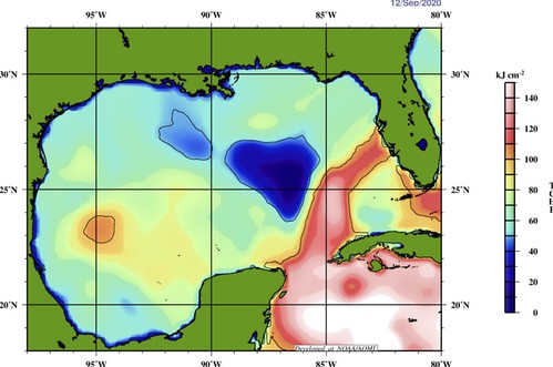
Even the “Tropical Cyclone Heat Potential” looks like there is plenty of “food” for the tropical cyclone to eat. But what is Tropical Cyclone Heat Potential? I’m so glad you asked! Here is a breakdown from NOAA: But! There may be another factor not expressed in just looking at the water temperatures. I grabbed a map of the Gulf of Mexico depth from a paper on Gulf fish. The paper, titled, “Ontogenetic spatial distributions of red grouper (Epinephelus morio) and gag grouper (Mycteroperca microlepis) in the U.S. Gulf of Mexico” had this map:

It shows that the overall depth of the Gulf. And I added the – general – track of Sally over the water depth. Right now Hurricane Sally is over some of the deepest waters in the Gulf. And thus the most voluminously warm waters. That may help to explain – as one of thepeices in the puzzle, at elast – why it recently began to erupt with new convection.
As you can see as it moves toward Louisiana, it will be moving over some of the deeper waters of the Gulf, but as it gets closer, and rides over the shallower shelf, it may get to a point where it slows down over water that is only 80 meters deep.
Without getting too into the weeds, even if the water is warmer than 26C for 80 meters deep, if it is only 80 meters deep, the water will “mix out” the warmer water faster and rain falls on it from above. In the same way a “kiddie pool” warms up and cools down faster than an olympic-sized pool. Depth and breadth matter.
So!
Depending on where Sally slows down, how slow it goes and when it turns north is likely to dictate exactly how strong it may become before making landfall.
Forecast for the Gulf
I know that is a ton of data. Perhaps even data overload. But if you are just here for the forecast, I have you covered, too.
Timeline
Monday: Sally is near the coastline and flinging the outer rainbands across parts of the Florida panhandle, southern Alabama, southern Mississippi and southeastern Louisiana – mainly after 3pm.
Tuesday: Landfall occurs late in the day. Rainbands continue across parts of southeastern Louisiana, southern Mississippi, Lower Alabama and the Florida panhandle. The storm slowly moves north.
Wednesday: The system moves slowly north, continuing to rain across Louisiana, Mississippi, Alabama and the Florida panhandle.
Thursday: Sally leaves the region.
Arrival time for wind
Pulled from the National Hurricane Center…

Rainfall estimates
The WPC shows that the entire region will be looking at the potential for heavy rain and flash flooding.

When does it end
Based on the guidance from the National Hurricane Center, Tropical Storm-force conditions begin to come to an end….
In Louisiana…
Coastline: Wednesday midday
Inland: Wednesday night
Well-inland: Thursday morning
In Mississippi…
Coastline: Wednesday afternoon
Inland: Thursday morning
Well-inland: Thursday night
In Alabama…
Coastline: Wednesday night
Inland: Thursday morning
Well-inland: Thursday afternoon
South Mississippi impacts
– Rain total estimates: 3″ – 8″ for most places, up to 12″ possible for a few spots
– Sustained wind estimate: 20 mph – 50 mph (lighter toward northwest of the area, stronger toward southeast)
– Length of time to deal with sustained wind: 36 hours; Tuesday morning – Wednesday night
– Wind gust estimate: 40mph – 75mph (lighter toward the northwest of the area, stronger toward the southeast)
– Length of time with potential wind gusts: 48 hours; Tuesday morning – Thursday morning
– Tornado threat: Tropical tornadoes possible ; EF-0 or EF-1 strength
– Length of tornado threat: 24 hours; Tuesday afternoon – Wednesday afternoon
The Bottom Line
Double check your hurricane preparedness kit now. Run to the store if you need any supplies. Look around the outside of your home and make sure all of the loose branches and debris aren’t within striking distance of your home. And clear any branches that look suspect. Bring any lawn furniture, or items you have outside that aren’t tied-down, inside. Clear any debris away from storm drains or gullies to make certain the water can be moved to larger creeks and rivers easier, and minimize localized flooding.
Based on the available data, this system shouldn’t be a catastrophic event for a lot of people. But the potential is there for some very heavy rain, flooding and gusty wind. The combination of those things could lead to a few folks being affected adversely. So, we encourage you to act like you may be one of those few folks. The old “prepare for the worst, hope for the best.”
Take the steps now to ensure you won’t have problems later.


