It looks like the westward progression of Hurricane Sally may be coming to an end. The latest water vapor imagery from the College of DuPage shows some modest flow in the mid-levels that is – very lightly – pushing Sally from the west.
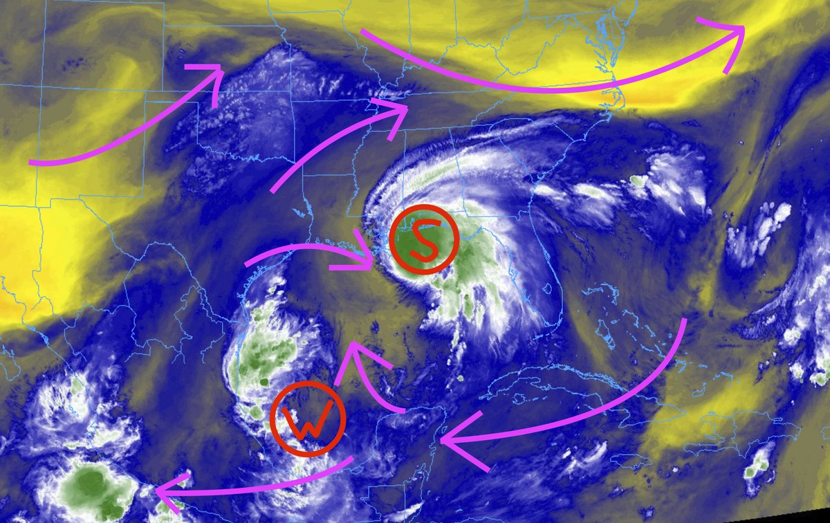
That will help to slow Sally to a crawl and eventually turn the storm to the north and eventually back to the northeast.
From the NHC
The satellite presentation of Sally has not changed much since overnight. A ragged eye is seen in WSR-88D radar imagery, with a band occasionally trying to wrap around the southwestern side. A NOAA reconnaissance aircraft has just recently provided a new center fix, and data from the center drop indicated the minimum pressure is 983 mb. The first pass through the northeastern quadrant suggests that the 50-kt wind field may have expanded, but there has been little change in peak winds reported by the aircraft. The intensity has been held at 75 kt pending additional data from the NOAA P-3 mission that has just begun. A highly elevated oil rig just northeast of the center reported peak has reported sustained winds of 69 kt with a gust to 86 kt around 1200 UTC this morning.

Sally has been meandering this morning, but the longer-term motion is northwestward or 315/2 kt. Sally remains within an area of weak steering flow, but a weak mid-level trough over the south-central United States is forecast to slide eastward over the next over the next couple of days. This pattern should cause Sally to move very slowly north-northwestward to northward over the next 24 hours, with the center of the hurricane nearing the northern Gulf Coast late tonight or Wednesday. By late Wednesday, Sally should turn northeastward as the aforementioned trough approaches Missouri and Arkansas. The new forecast has been nudged slightly eastward in the early portion of the track forecast, but the latter portion is very close to the previous advisory. The new track lies a little to the west of the various consensus aids in deference to the typically reliable GFS and ECMWF models that are near the left edge of the guidance envelope. Sally’s forward motion is forecast to be around 5 kt or less throughout the forecast period, which will result in a long period of heavy rainfall and historic flooding along the north-central Gulf Coast.
Moderate westerly shear and upwelling beneath the slow moving hurricane are likely to prevent strengthening today. The shear is forecast to increase tonight and although some slight weakening could occur before the center reaches the coast, Sally is predicted to remain a dangerous hurricane through landfall. Once Sally moves
inland, rapid weakening is expected and circulation is forecast to lose definition and dissipate by day 4.
Users are reminded to not focus on the specific timing and location of landfall. Life-threatening storm surge, historic flash flooding from heavy rainfall, and dangerous winds will affect a large portion of the north-central Gulf Coast during the next few days.
FORECAST POSITIONS AND MAX WINDS
INIT 15/1500Z 29.1N 88.2W 75 KT 85 MPH
12H 16/0000Z 29.6N 88.2W 75 KT 85 MPH
24H 16/1200Z 30.2N 88.1W 70 KT 80 MPH
36H 17/0000Z 31.0N 87.6W 55 KT 65 MPH…INLAND
48H 17/1200Z 31.9N 86.6W 35 KT 40 MPH…INLAND
60H 18/0000Z 32.6N 85.2W 25 KT 30 MPH…INLAND
72H 18/1200Z 33.0N 83.6W 20 KT 25 MPH…POST-TROP/REMNT LOW
96H 19/1200Z…DISSIPATED
Key Messages
Life-threatening storm surge is expected from the Mouth of the Mississippi River to the Okaloosa/Walton County Line in the Florida Panhandle. The highest inundation is expected along the Alabama coast, including Mobile Bay.

Historic life-threatening flash flooding is likely through Wednesday along and just inland of the coast from the western Florida Panhandle to far southeastern Mississippi. Widespread moderate to major river flooding is forecast along and just inland of the central Gulf Coast. Significant flash and urban flooding, as well as widespread minor to moderate river flooding, are likely across inland portions of Mississippi, Alabama, northern Georgia, and the western Carolinas through the week.

Hurricane conditions are expected today within portions of the Hurricane Warning area along the Mississippi and Alabama coastlines and the western Florida Panhandle. But Tropical Storm Force conditions are going to extend out much farther.

Water Temperatures
Looking at the 26C isotherm, you can see that there appears to be plenty of warm water – even to depth – out into the Gulf.

Looking at the Tropical Cyclone Heat Potential out in the Gulf, you can see that some of the waters have been cooled a bit from two or three days ago. Some of this is due to Sally’s rain cooling the surface temperature of the water. That cooler water then sinks in the Gulf and “upwells” the warmer water from below. But the “warmer” water below isn’t as warm as the water was, before Sally, at the surface.

As I mentioned the other day, the depth of the water – in general – may play a role in Sally’s ability to strengthen. So, I grabbed a map of the Gulf of Mexico depth from a research paper on Gulf fish. The paper, titled, “Ontogenetic spatial distributions of red grouper (Epinephelus morio) and gag grouper (Mycteroperca microlepis) in the U.S. Gulf of Mexico” had this map:

It shows that the overall depth of the Gulf. Below, I added the – general – area where Sally is centered as well as a blue area where the rains are cooling the water.

Right now, Hurricane Sally is over some of the deepest waters in the northern Gulf. And thus the most voluminously warm waters. But they aren’t as warm as they were, say, two days ago. On top of that, the northern Gulf shelf goes from very deep to very shallow… very quickly. And shallow water is much easier to cool down than deep water.
That may help to explain – as one of the pieces in the puzzle, at least – why Sally spent yesterday exploding and last night and today remaining stagnant, and even weakening. It is not trying to work with water that is much shallower to the north. Sometimes only 50 to 100 meters deep.
As I’ve been talking about for a few days now – and without getting too into the weeds – even if the water is warmer than 26C all the way down, if it is only 80 meters deep, the water will “mix out” the warmest water faster as rain falls on it from above. In the same way a “kiddie pool” warms up and cools down faster than an olympic-sized pool. Depth and breadth matter.
So!
Since it is slowing to a crawl in an area with shallower water, it could be hypothesized that Sally is unlikely to get any stronger than it is right now.
The Bottom Line for South Mississippi (but not the coast)
Landfall is now pegged to be Wednesday, around midday and into the afternoon. Somewhere along the Mississippi or Alabama coastline. More likely to be the Alabama coastline, at this point.
It looks like due to the increased shear aloft, coming at the storm from the west, the entrained dry air for part of yesterday, the shallow water, and the trough to the north set to pick up Sally, the threat to South Mississippi is diminishing. It looks like there will still be some pretty gusty wind, and the occasional rainband with very heavy rain and gusty wind. but the potential for more than five inches of rain for the area is dropping. And since flooding was the main concern, the level of concern is dropping.
Is the area in the clear? Far from it.
Can you relax a bit? Totally.
Again, rainbands with locally heavy rain will be possible. You may still see up to five inches of rain by the time this is all said and done. Some folks may even see up to eight inches of rain. Part of the area will also be close enough to Hurricane Sally to experience Tropical Storm force wind conditions, too. For everyone, wind gusts up to 40mph will be possible and rainfall totals up to three inches is still the forecast.
Since Sally is stalling out off the coast, we will be in this weather pattern of off-and-on showers and gusty wind for another 36 to 48 hours.


