With the wake of the updated models on the Central American Gyre, it has now been updated to a Tropical Invest. I have my tropical discussion below, however whether or not it moves strictly north or to the east, it will have some sort of effect on us this week. Overall, the first part of this week is going to be a hot one, however with a big upper low pressure system and a cold front moving in, we’ll see some moisture and rain possible towards the middle of the week.
To start off the week, we’ll have an increase in moisture flow as the southwestern ridge moves towards the east. This will cause the dew point to rise and keep it hot and humid on Monday and Tuesday. As we move into Wednesday, we’ll see the shift in wind due to the Tropical influence and also a closed low to our west. With this, a cold front will move to the east increasing rain chances for areas of central and western Mississippi. Parts of the Pinebelt will also see some chances of rain.
For Thursday, the temperatures will begin to fall into the 80s as the Tropical Invest makes its way towards the Gulf Coast. With this, some heavy rain is possible across our neck of the woods. Areas around east to north Mississippi and many parts of Alabama will see heavy rain from the outer bands of the storm. As it moves out, temperatures will begin to reduce across the region for a few days.
Now, to our Tropical Discussion.
Invest Ten-E
Currently, the CAG south of the Yucatan is beginning to pick up some steam with more convective clouds firing off. It isn’t quite organized yet, however it will gain a little momentum as we near the beginning of the week. The southerly winds out of the Caribbean are giving it the push to make it out of the Yucatan, however it will take a couple of days.
Here’s where it starts to get tricky. Several of the mainline models, like the GFS, Canadian, Euro, and UK models are suggesting that this storm will move east as it moves up the Gulf. Why? I’ll show you!
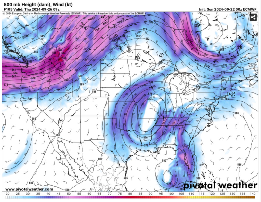
There’s a few things to unpack here, but for the most part, they’re all suggesting something similar. A stout shortwave trough in the eastern US along with an almost longitudinal ridge in the western US. A few models suggest that the shortwave above us along with a cold front at the surface that would steer this thing towards the eastern Gulf of Mexico and towards Florida. The current main detractors from this are the GFS and the Euro-AIFS models. The GFS has a more closed low just to the west of the Euro’s (above) and the Euro-AIFS has the low further north and east towards the mid-South.
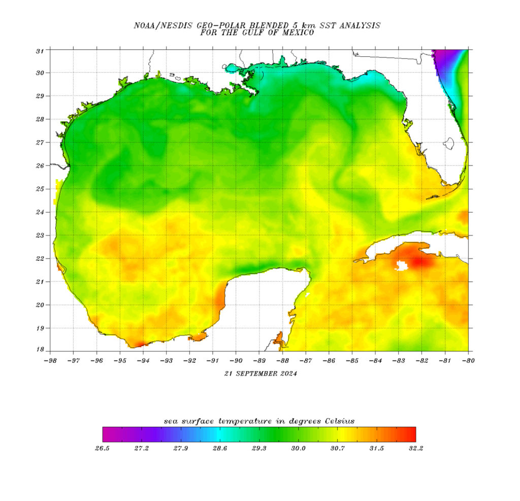
Another factor we have to think about is the sea surface temperatures. If you look at the graphic above, you can see there is plenty of very warm water for this storm to feed off. If we look at the Gulf itself, there is a current moving towards the northern Gulf of Mexico.
With all this in mind, Invest TEN-E is going to be heading north up the Gulf in the next several days. Depending on the setup of the upper levels, this could move further east in the Gulf. The intensity of the Invest is still varied with the models, however many are suggesting tropical storm strength and even a possible hurricane. The storm itself looks a bit lopsided as it moves up the coastline, however models like the GFS suggest it will become better organized before it makes landfall.
And just as a disclaimer: THIS CAN CHANGE, stay tuned for the next few days because even though the models are aligning, there will be tweaks to the forecast.
Regional Day-to-Day Forecast
Tonight – Mostly clear. Lows around 70. South winds around 5 mph this evening, becoming light and variable.
Monday – Sunny. Highs in the lower 90s. Light and variable winds, becoming south around 5 mph in the afternoon.
Monday Night – Partly cloudy in the evening, then becoming mostly clear. Lows around 70. South winds around 5 mph in the evening, becoming light and variable.
Tuesday – Sunny. Highs in the lower 90s. South winds around 5 mph.
Tuesday Night – Partly cloudy. Lows in the lower 70s. South winds around 5 mph in the evening, becoming light and variable.
Wednesday – Mostly sunny. A chance of showers and thunderstorms in the afternoon. Highs in the upper 80s. Chance of rain 40 percent.
Wednesday Night – A chance of thunderstorms in the evening. Mostly cloudy with a chance of showers. Lows in the upper 60s. Chance of rain 40 percent.
Thursday – Partly sunny. A chance of showers. Highs around 80. Chance of rain 40 percent.
Thursday Night – Mostly cloudy with a chance of showers in the evening, then partly cloudy after midnight. Lows in the mid 60s. Chance of rain 40 percent.
Friday – Mostly sunny. Highs in the lower 80s.
Friday Night Through Sunday – Mostly clear. Lows in the mid 60s. Highs in the mid 80s.


