Tropical Storm Cristobal has formed deep in the bay of Campeche. The Hurricane Hunters are on their way to investigate the storm.
Just one day after the start of #HurricaneSeason, the @53rdWRS are headed into Tropical Depression Three, located in the Bay of Campeche. Always #ReserveReady, we gather weather data for the @NHC_Atlantic which helps improve their forecast models so everyone can be #WeatherReady. pic.twitter.com/xYixCSw81v
— 403rd Wing (@403rdWing) June 2, 2020
The latest from the NHC:
…DEPRESSION STRENGTHENS TO A TROPICAL STORM…
Observations from an Air Force Reserve Unit Hurricane Hunter
aircraft indicate that Tropical Depression Three has strengthened
into Tropical Storm Cristobal. The maximum winds are estimated to
be 40 mph (65 km/h) with higher gusts.SUMMARY OF 1115 AM CDT…1615 UTC…INFORMATION
———————————————-
LOCATION…19.3N 92.7W
ABOUT 150 MI…245 KM WSW OF CAMPECHE MEXICO
ABOUT 135 MI…215 KM NE OF COATZACOALCOS MEXICO
MAXIMUM SUSTAINED WINDS…40 MPH…65 KM/H
PRESENT MOVEMENT…SW OR 230 DEGREES AT 3 MPH…6 KM/H
MINIMUM CENTRAL PRESSURE…1004 MB…29.65 INCHES

Model Data
The deterministic models continue to show a ridge of high pressure stepping in to block Cristobal’s trip due north.
However, some of the ensemble guidance is starting to show the ridge may not be as pronounced as originally anticipated.

The GEFS now shows less of a trend to shove Cristobal to the west and toward Texas. While the EPS, still shows a nudge to the west, though, not as pronounced.
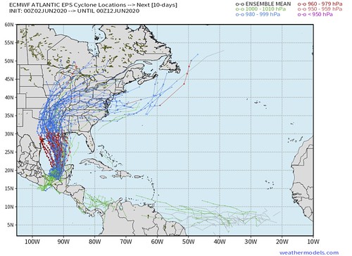
This morning, model guidance is still showing Cristobal is most likely to remain at Tropical Storm strength, and does not become a hurricane during its lifespan.

That said, the Rapid Intensification numbers from the SHIPS guidance is coming back a bit “hotter” this morning.

Keep in mind that the Gulf is still very warm, too. And the area where it is the warmest is the area that Cristobal is forecast to run through.

What does it all mean?!
Cristobal is a Tropical Storm now and will eventually drift north into the central sections of the Gulf of Mexico. After that point, there is still some uncertainty about its track.
At the end of the day, it also means we are not just starting to get a better idea about where this thing is going and how strong it will be when it gets there. Like usual, meteorologists and computer models have a difficult time predicting a tropical system before it forms. Now that it is getting better wrapped up, the models are able to get a hold of it better and meteorologists are able to make more sound predictions.
On top of that, the Hurricane Hunters are headed into the storm today and will be able to relay valuable information back to the NHC and that data will then get plugged into the modeling to help further improve the forecast.
Historically speaking, these early season Central American Gyre storms are lopsided, poorly organized and very – VERY! – proficient rain producers. That means, historically, wind is less of a threat than flooding.
What does this mean for me, though, Nick?
It depends on where you live and how things shake out. However, right now, I would say that if you live between Corpus Christi and Pensacola, you need to…
1. Start watching your local television meteorologist for forecast updates, checking with the National Hurricane Center every morning (you can read their updates on this website), or just check back here for updates, too.
2. Check your hurricane preparedness kit to make sure that your stocked up with supplies. In particular, water, food and medications. I know during the pandemic a lot of us are probably stocked up with extra supplies anyway, but double check those. For more info on what needs to be in your kit, head here!
3. Check out in your yard (if you have one) to see how you can mitigate your flooding risk. Usually these early season storms drop a lot – I mean, a LOT – of water. Some early estimates from the model data show the potential for some places to pick up over a foot of rain from whatever may drift north, regardless of strength. So take some steps now to look around your house and figure out what may help to move water away from your home and toward storm drains, creeks, or streams.


Thank you, Nick! We appreciate you and all the weather team!