As Tropical Storm Sally presses to the west-northwest across the Gulf of Mexico, it is now slated to be a Category 2 Hurricane at landfall. But that is not set in stone. There is still room for a little more strengthening. Or, perhaps, not as much strengthening.
Like most tropical forecasts, it is difficult to naildown specifics. And intensity is something, historically, that model guidance and humans don’t do very well at forecasting.
Quick look at the NHC Forecast

10AM SUMMARY
LOCATION…27.5N 84.9W
ABOUT 135 MI…220 KM W OF ST. PETERSBURG FLORIDA
ABOUT 280 MI…450 KM ESE OF THE MOUTH OF THE MISSISSIPPI RIVER
MAXIMUM SUSTAINED WINDS…60 MPH…95 KM/H
PRESENT MOVEMENT…WNW OR 295 DEGREES AT 12 MPH…19 KM/H
MINIMUM CENTRAL PRESSURE…998 MB…29.48 INCHES
DISCUSSION AND OUTLOOK
At 1100 AM EDT (1500 UTC), the center of Tropical Storm Sally was located near latitude 27.5 North, longitude 84.9 West. Sally is moving toward the west-northwest near 12 mph (19 km/h), and a west-northwestward or northwestward motion is expected through Monday. A decrease in forward speed and a turn toward the north-northwest is forecast on Monday night, and slow north-northwestward motion is expected Tuesday. On the forecast track, the center of Sally will move over the eastern Gulf of Mexico today, move over the north-central Gulf of Mexico tonight and Monday, and approach the north-central Gulf Coast within the hurricane warning area late Monday and Monday night. Sally is expected to move farther inland over southeastern Louisiana on Tuesday and Tuesday night.
Data from an Air Force Reserve Hurricane Hunter aircraft indicate that the maximum sustained winds have increased to near 60 mph (95 km/h) with higher gusts. Strengthening is expected over the next day or so, and Sally is forecast to become a hurricane on Monday, with some additional strengthening possible before landfall Monday night.
Tropical-storm-force winds extend outward up to 90 miles (150 km) primarily to the east of the center.
The latest minimum central pressure estimated from reconnaissance aircraft data is 998 mb (29.48 inches).
HAZARDS AFFECTING LAND
STORM SURGE: The combination of a dangerous storm surge and the tide will cause normally dry areas near the coast to be flooded by rising waters moving inland from the shoreline. The water could reach the following heights above ground somewhere in the indicated areas if the peak surge occurs at the time of high tide…
Mouth of the Mississippi River to Ocean Springs, MS including Lake Borgne…7-11 ft
Port Fourchon, LA to Mouth of the Mississippi River…4-7 ft
Ocean Springs, MS to MS/AL Border…4-7 ft
Lake Pontchartrain and Lake Maurepas…4-6 ft
MS/AL Border to AL/FL Border including Mobile Bay…2-4 ft
AL/FL Border to Chassahowitzka, FL including Pensacola Bay,
Choctawhatchee Bay, and Saint Andrew Bay…1-3 ft
Burns Point, LA to Port Fourchon, LA…1-3 ft
Overtopping of local levees outside of the Hurricane and Storm Damage Risk Reduction System is possible where local inundation
values may be higher than those shown above.
The deepest water will occur along the immediate coast near and to the right of the landfall location, where the surge will be accompanied by large and damaging waves. Surge-related flooding depends on the relative timing of the surge and the tidal cycle, and can vary greatly over short distances. For information specific to your area, please see products issued by your local National Weather Service forecast office.
WIND: Hurricane conditions are expected within the warning area starting late Monday. Tropical storm conditions are possible within the watch area and expected within the warning area beginning Monday.
RAINFALL: Sally is expected to produce additional rainfall of 1 to 3 inches across southwestern Florida with isolated amounts of 6 inches along that coast through Monday. This rainfall may produce flash and urban flooding and prolong high flows and ongoing minor flooding on rivers across west-central Florida.
Sally is expected to be a slow moving system resulting in significant flash flooding for the central Gulf Coast through the middle of the week. Sally is expected to produce rainfall of 6 to 12 inches with isolated amounts of 20 inches over portions of the central Gulf Coast from the western Florida Panhandle to far southeast Louisiana from Monday through the middle of the week.
Sally is forecast to turn inland Wednesday and track into the Southeast with rainfall of 4 to 8 inches possible farther inland across much of Mississippi and Alabama with further heavy rain anticipated for portions of Tennessee, northern Georgia and western North Carolina. Flash and urban flooding is possible, as well as minor to isolated moderate flooding on rivers for Mississippi and Alabama. Flash, urban, and minor river flooding is possible for portions of Tennessee, northern Georgia and western North Carolina.
SURF: Swells will spread northward along the west-central coast of Florida and reach the Florida Panhandle and the northern Gulf Coast during the next couple of days. These swells are likely to cause life-threatening surf and rip current conditions. Please consult products from your local weather office.
NHC Technical Discussion
Although the center of Sally remains near the northwestern edge of the deep convection, there is a large area of convection and some banding evident over the southeastern portion of the circulation. An Air Force Reserve Hurricane Hunter aircraft investigating the storm this morning reported a peak 850-mb flight-level wind of 62 kt, and believable SFMR winds of around 50 kt, and these data are the basis for the 50-kt initial wind speed. The plane reported minimum pressures in the 996-998 mb range, with the higher value being the most recent information available.
Northwesterly shear continues over the cyclone, but this shear is expected to decrease later today and tonight as Sally moves beneath a narrow upper-level ridge axis. This more conducive upper-level pattern is expected to allow the tropical storm to strengthen while it moves over the north-central Gulf of Mexico tonight and Monday. Most of the intensity guidance calls for Sally to become a hurricane in about 24 hours and so does the official forecast. Additional strengthening is expected after that time and Sally could be slightly stronger at landfall than indicated below since it is forecast to reach the coast between the 36 h forecast point and 48 h when it is inland over southeast Louisiana. The NHC intensity forecast is close to the consensus aids through 24 hours and at or just above the SHIPS, LGEM and HFIP corrected consensus aids at 36 and 48 hours.
Sally is moving west-northwestward at about 10 kt. The tropical storm should continue on that general heading and speed over the next 12 to 24 hours as it steered around the southern flank of a mid-level ridge. After 24 hours, Sally is expected to be near the western portion of the ridge which should cause the storm to slow down and turn northwestward. The global models have trended toward slightly more ridging over the northern Gulf during the next 24 hours, and the track guidance has edged westward. The NHC track has been adjusted slightly westward and lies near the lastest run of the GFS, but is not as far west as the ECMWF and the various consensus aids. As Sally rounds the ridge in 48 to 72 h, the steering flow is expected to be quite weak, and a slow northward motion is forecast at that time. Afterward, a north-northeastward to northeastward motion should commence as the cyclone moves in that direction ahead of a short-wave trough.
Users are reminded to not focus on the exact details of the track or intensity forecasts, as the average NHC track error at 36-48 h is 60-80 miles and the average intensity error is 10-15 mph. In addition, wind, storm surge, and rainfall hazards will extend far from the center. Unfortunately, confidence is increasing that Sally’s expected slow forward speed near the Gulf Coast will exacerbate the storm surge and heavy rainfall threats.
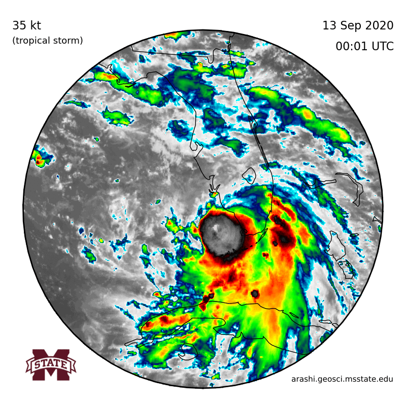
A quick look at Sally
Sally is riding some pretty subtle flow in the atmosphere to the west-northwest this morning. It sits under a ridge of high pressure aloft, so it is doing well to build convection and grow in size and intensity.
Potential outcomes
The general overall pattern within the current “bigger picture” shows that there are a few forces acting upon Sally at the moment.

The ridge of high pressure to the north (1), the flow ahead of the ridge (2), the nudge Sally is getting from the east (3), the other disturbance in the Gulf (4), and the click-wise rotation off the coast of Virginia (5).

A lot of the guiding of Sally is going to be pretty subtle during the next 48 hours. So any change in the forcing within the forecast data can have reasonable consequences down the line with respect to the final landfall and intensity. For example, here are a few possibilities…
Further West…
Assuming there is no change in the intensity forecast, if the ridge of high pressure (1) to the north slides through and doesn’t nudge the flow ahead of the ridge (2) further south, it would allow Sally to track a bit further west before getting “picked up” by the mid-level winds and pulled to the north and northeast.
Assuming there is a change to the intensity forecast, if Sally is weaker it would also allow it to make it farther west before turning north. It would also gain less latitude while moving west-northwest before making the turn to the north.
Further East…
Assuming there is no change to the intensity forecast, If the ridge of high pressure (1) pushed further south and the flow ahead of the ridge (2) also gets pushed south, it will “pick up” Sally a bit earlier and shift it to the north and northeast quicker. This would also limit the slowing down and stalling out over the Gulf that is currently in the forecast right before landfall. It may also shift the area that would be dealing with the greatest impacts (heaviest rain, strongest wind, etc) to the east. So places like Alabama and the Florida panhandle would get the worst of Sally instead of Louisiana and Mississippi.
Assuming there is a change to the intensity forecast, if sally is stronger it would also turn to the north a bit sooner from feeling the tug of Coriolis. A jump in intensity from a burst of Rapid Intensification may “hop” the center to the north along its trek, too. With that said, a full disclosure of transparency, I am uncertain what that would mean for any slowing and stalling. I would estimate that it would limit the stalling, but it may still slow down as it goes to make the turn.
Stronger
This goes along the same lines as above. Assuming Sally develops into a stronger storm, and is, say, all the sudden a Category 4 Hurricane. It would feel the tug of the Coriolis effect and be pulled north. This would limit the trek westward and instead it would start the turn sooner. How soon? It would depend on a lot of factors. But it would tend toride up the east side of the current forecast cone.
Weaker
Firstly, I don’t know if “weaker” is a word or not. I think “more weak” is grammatically correct but seems counter-intuitive. Less strong, perhaps, would work here? Anyway…
If the storm wasn’t as intense as forecast, it would continue to trek further to the west as it wouldn’t have as much deep convection and may not feel the tug of the flow to the north of it, pulling it back to the north and northeast. That said, given that it wouldn’t feel the tug, it wouldn’t likely slow down as much, either. Since the slowing is due to the “reverse course” the larger system is having to take. Ifit isn’t as large, it will just keep cruising.
Water Temperatures
Looking at the 26C isotherm, you can see that there appears to be plenty of warm water – even to depth – for Sally to work with.

The path ahead for Sally takes it through water with a 26C isotherm depth of 60-80 meters. Plenty deep to support a Category 1 Hurricane.
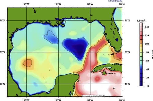
Even the “Tropical Cyclone Heat Potential” looks like there is plenty of “food” for the tropical cyclone to eat. But what is Tropical Cyclone Heat Potential? I’m so glad you asked! Here is a breakdown from NOAA:
Tropical Cyclones (known as Hurricanes in the Atlantic and eastern Pacific Ocean basins and as Typhoons in the western Pacific basin) are some of the most destructive weather events on the planet. The path of these storms and their intensity are the two main outputs of the forecast models, as they provide vital information for saving lives and determining possible economic and environmental impacts. In addition to the appropriate atmospheric conditions, the heat stored in the upper layers of the ocean plays an important role in tropical cyclone formation and intensification.
Tropical cyclones require ocean temperatures above 26℃ for development. AOML’s Tropical Cyclone Heat Potential (TCHP) quantifies the upper ocean heat content from the ocean surface to the 26℃ isotherm depth, and it represents a robust measure of how much energy is available in the ocean to sustain or modify the intensity of a tropical cyclone. High values of TCHP have been associated with the sudden intensification of a number of tropical cyclones (see references). Fields of TCHP are created daily and serve to identify regions where the ocean conditions are appropriate for tropical cyclone intensity changes.
Similarly, TCHP was also used to determine the magnitude of storm surge on specific areas.
Zooming into Sally’s path over the TCHP map, you can see that it will be traversing over some pretty high numbers.

But! There may be another factor not expressed in just looking at the water temperatures. I grabbed a map of the Gulf of Mexico depth from a paper on Gulf fish. The paper, titled, “Ontogenetic spatial distributions of red grouper (Epinephelus morio) and gag grouper (Mycteroperca microlepis) in the U.S. Gulf of Mexico” had this map:

It shows that the overall depth pf the Gulf. And I added the – general – track of Sally over the water depth.

As you can see as it moves toward Louisiana, it will be moving over some of the deeper waters of the Gulf, but as it gets closer, and rides over the shallower shelf, it may get to a point where it slows down over water that is only 80 meters deep.
Without getting too into the weeds, even if the water is warmer than 26C for 80 meters deep, if it is only 80 meters deep, the water will “mix out” the warmer water faster and rain falls on it from above. In the same way a “kiddie pool” warms up and cools down faster than an olympic-sized pool. Depth and breadth matter.
So!
Depending on where Sally slows down, how slow it goes and when it turns north is likely to dictate exactly how strong it may become before making landfall.
Rapid Intensification potential
It’s not high. But it isn’t low either. It is somewhere in the middle. And that is, in large part, due to all of the things mentioned above.
The SHIPS model that quantifies how likely Rapid Intensification will be, shows numbers around 10-percent. And while 10-percent may sound low, remember that with weather, not all percentages are weighed the same. During severe weather, we say there is a 10-percent tornado risk, that means “buckle up!” where a 10-percent chance for rain means you’ll probably stay dry.
In this case, 10-percent has to be weighed against climatology. And you can see on the graphic here that a lot of these numbers are 2- to 3-times higher than the climatological mean.

It is interesting to note the 65kts/72hr at 13-percent in there. Because it should be making landfall in about 60 hours. So, really, the SHIPS model is showing a 65kt increase in 60 hours. Which would be an incredible feat. And there is a better than 1-in-10 shot that it happens.
Again, not high. But also not, necessarily, low, either.
That’s great and all, Nick, but I’m just here for the forecast…
I know that is a ton of data. Perhaps even data overload. But if you are just here for the forecast, I have you covered, too.
Timeline
Monday: Sally is near the coastline and flinging the outer rainbands across parts of southern Alabama, southern Mississippi and southeastern Louisiana after 3pm.
Tuesday: Landfall occurs during the early morning hours. Rainbands continue across parts of southeastern Louisiana and southern Mississippi. The storm slowly moves north.
Wednesday: The system moves slowly north, continuing to rain across Louisiana and Mississippi.
Thursday: Sally leaves the region.
Arrival time for wind
Pulled from the National Hurricane Center…

Rainfall estimates
The WPC shows that the entire region will be looking at the potential for heavy rain and flash flooding.

When does it end
Based on the guidance from the National Hurricane Center, Tropical Storm-force conditions begin to come to an end….
In Louisiana…
Coastline: Wednesday midday
Inland: Wednesday night
Well-inland: Thursday morning
In Mississippi…
Coastline: Wednesday midday
Inland: Thursday morning
Well-inland: Thursday night
In Alabama…
Coastline: Wednesday morning
Inland: Wednesday midday
Well-inland: Thursday morning
South Mississippi impacts
– Rain total estimates: 3″ – 8″ for most places, up to 15″ possible for a few spots
– Sustained wind estimate: 20 mph – 50 mph (lighter toward northeast of the area, stronger toward southwest)
– Length of time to deal with sustained wind: 48 hours; Monday night – Wednesday night
– Wind gust estimate: 40mph – 75mph (lighter toward the northeast of the area, stronger toward the southwest)
– Length of time with potential wind gusts: 36 hours; Tuesday morning – Wednesday night
– Tornado threat: Tropical tornadoes possible ; EF-0 or EF-1 strength
– Length of tornado threat: Tuesday morning – Wednesday night
The Bottom Line
Double check your hurricane preparedness kit now. It is a Sunday! So you should (hopefully) have some time to run to the store if you need any supplies. Look around the outside of your home and make sure all of the loose branches and debris aren’t within striking distance of your home. And clear any branches that look suspect. Bring any lawn furniture, or items you have outside that aren’t tied-down, inside. Clear any debris away from storm drains or gullies to make certain the water can be moved to larger creeks and rivers easier, and minimize localized flooding.
Based on the available data, this system shouldn’t be a catastrophic event for a lot of people. But the potential is there for some very heavy rain, flooding and gusty wind. The combination of those things could lead to a few folks being affected adversely. So, we encourage you to act like you may be one of those few folks. The old “prepare for the worst, hope for the best.”
Take the steps now to ensure you won’t have problems later.


