Hello all and happy Friday! The Atlantic is continuing to remain mostly quiet with no significant tropical activity expected. Despite this lack of activity however, there is always things to discuss and track as we get closer and closer to the height of the Atlantic Hurricane season in August and September.
Since there are no highlights currently from the NHC, we will jump straight into the current state of the tropics, see how they will progress in the models, and then wrap it up with conclusions on what this all means for tropical activity.
Current Tropical Conditions

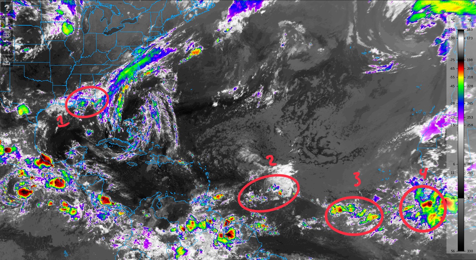
Taking a look at the current IR image out over the Atlantic, despite the lack of more robust tropical activity, we can still pick out areas of interest that we can track in the model guidance moving forward. Area of interest 1 is thunderstorm and shower activity associated with the passing front leading to enhanced rainfall along the coastal Gulf areas. Areas of interest 2, 3, and 4 are tropical waves that are moving off the coast of Africa and into the open Atlantic.

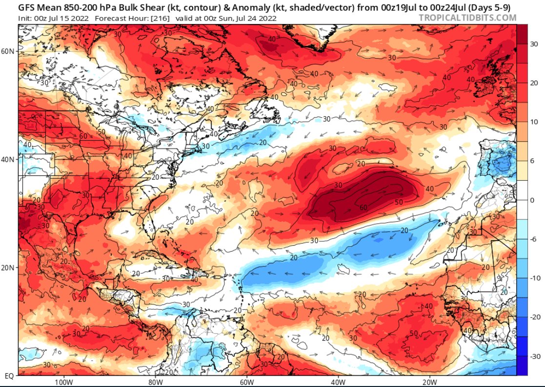
Taking a look the current wind shear across the Atlantic basin, we can see a lot of red coloring on the map, indicating relatively high wind shear values of 40+ kts. Wind shear prevents tropical development, as storms need a consistent vertical structure in order to maintain their strength and form an organized system. With high levels of shear, this does not happen and thus storms have a hard time becoming more organized. This is one of the reasons that the tropics is expected to mainly remain quiet in the future, as current conditions do not support organized and mature systems.
Next we will take a look at the moisture content, another important variable to look into.

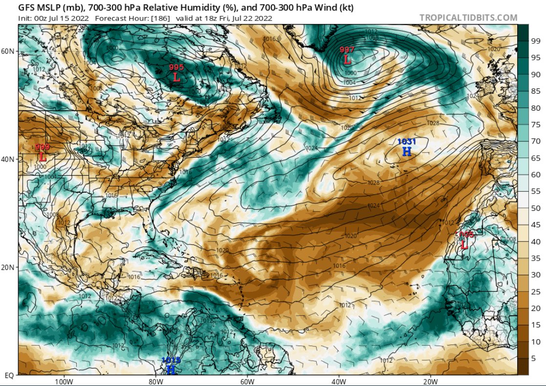
As you can see from the relative humidity profile, there is a lot more dry air than moist throughout much of the Atlantic Basin. With such a strong presence of dry air, systems have another thing working against them as anything that happens to over come the wind shear is likely to suffer from a lack of available moisture and quickly die off.
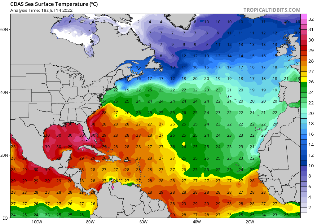
It is also always good to take a quick look at the current sea-surface temperatures, as this is another important factor in tropical system development.

Current sst’s are supportive of tropical development, as much of the Atlantic off the coast of Africa and into the Caribbean is above 26C (79F), which is sufficient energy to fuel more complex storm systems.
Model Prognosis
Taking a look at how these variables will change with time, we can get a glimpse at how any current system in the tropics will develop, or if any new systems that emerge would experience better environmental conditions for development.

Looking forward 5 to 9 days, we can see the current wind shear does not get much better in terms of favorable tropical conditions. Wind shear values remain exceptionally high just off the coast of Africa, with a contoured area of 50kts! throughout the rest of the Atlantic, wind shear will remain anomalously high, which is likely to completely prevent any of the disturbances highlighted above from forming into anything notable.


Looking at the relative humidity for the next week, not much change is expected with huge inflows of dry air still expected to dominate much of the tropical Atlantic. Once again, system are unlikely to form due to the shear, but even any cluster of showers and thunderstorms is likely to weaken in areas with the drier air (brown colors). Most clusters of storms which survive are likely to remain along the belt of moisture closer to the equator.
Conclusions
Well there you have it! It is defiantly a shorter discussion, however when the weather is this quiet, you can only talk about so much! While the Atlantic basin is expected to remain quiet for the time being, which is good for any trips or vacations, hurricane season certainly is not over. A reminder that the peak of the Atlantic hurricane season is not until late August and into September, where a majority of named storms occur.

Overall, I would enjoy the quiet weather while it lasts, as you never know what the future holds! Despite the quiet weather, it is always important to check back for future updates to follow up with any potential changes in tropical activity.

