Good morning folks and TGIF!
For today’s discussion, we can break this into three parts. The first of which is the usual look at the general pattern across the country; then the next two sections will be of the first and second weather patterns we’ll be seeing this week: hot & wet and hot & not-so-wet.
Current Synoptic Picture

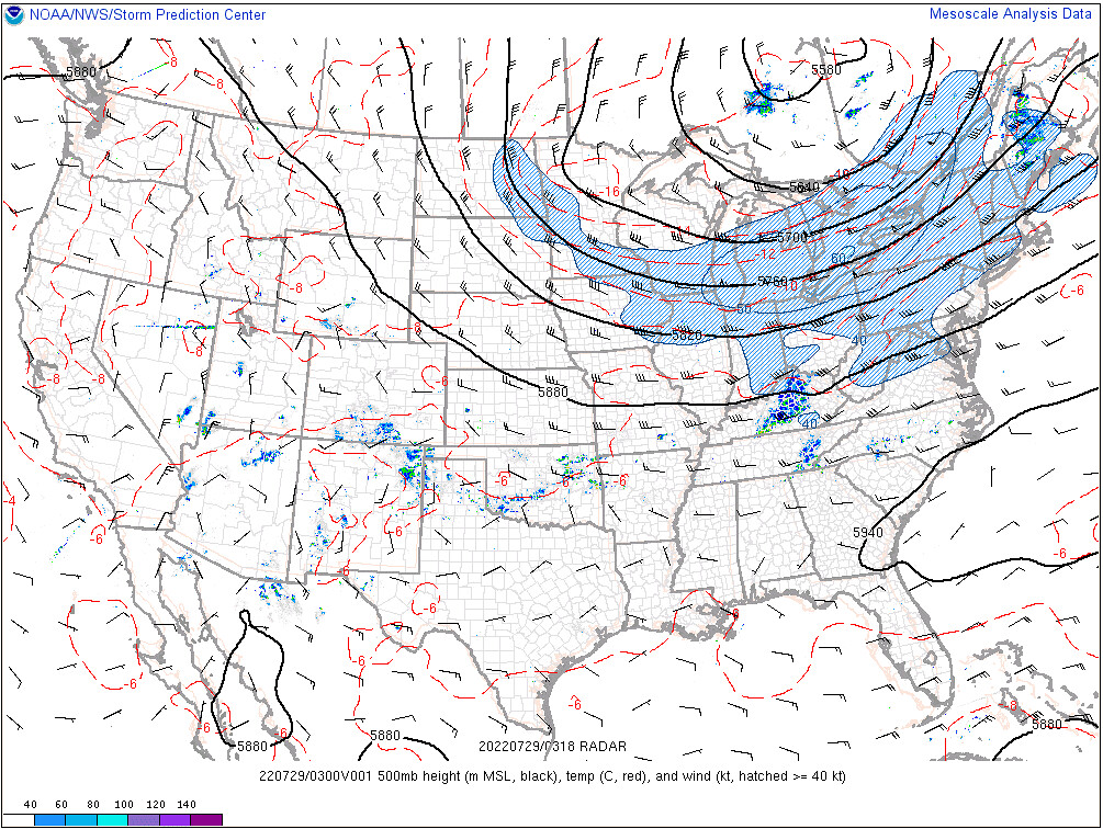
The major weather influences across the country this week is the large ridge over the West Coast, bringing a heat wave to the Pacific Northwest, an upper-level low near the border of Ontario and Quebec, resulting in general troughiness over the northern United States east of the Rockies, and finally a relatively weak sub-tropical low currently extending from the Georgia/South Carolina border westward toward western Texas.

The airmass responsible for this upper-level sub-tropical ridge over the Southeast is very moist, with precipitable water values exceeding 2″ for large portions of the Southeast. This moisture, along with the high temperatures continues to make for a miserable muggy experience across much of the region.
The last feature to make note of in the Southeast is a very slow moving cold front, whose position is seen as the northernmost local precipitable water maxima in the image above, roughly spanning from eastern Oklahoma, through Arkansas and extending into Tennessee.
Today through Sunday: Hot & Wet
As I’ve already mentioned, most of the area is under the influence of the upper-level sub-tropical ridge. The state of Mississippi, though, is almost split in two by the warmer, humid air mass directly underneath this ridge, and the slightly cooler and slightly drier airmass to the north associated with the upper-level low. As the strength of the sub-tropical ridge overhead ebbs and flows, the boundary between these two airmasses will hang around the area, bringing an increased chance for afternoon showers and thunderstorms to southwestern Mississippi as convection will fire along the front, and to the south of the front where storms may initiate over outflow boundaries.

According to the forecast reflectivity from the NAMNST above, most of the showers and thunderstorms will be in northern and central Mississippi for Friday. Friday night, however, the sub-tropical ridge over the region begins weaken slightly, which allows for the front to slide ever-so-slightly to the south. This will bring the chances for afternoon showers and thunderstorms for much of the state for Saturday. This also means that some extra cloud cover will help to keep temperatures down slightly on Saturday. By Sunday, however, the ridge begins to strengthen again, pushing the boundary to the north beginning Monday morning, removing the extra threat for showers and storms from the region and to the north.
While this won’t guarantee rain for the region, the chances for rain will be greater, especially compared to the rest of next week…
High temperatures will remain nearly constant through this time, with highs in the low-to-mid 90s across southwestern Mississippi expected. However, with dewpoints in the 70s across the region, the apparent temperature will exceed 100F for most locations.


Through the End of Next Week: Hot & Not-so-Wet
With the removal of the boundary to the north by Monday afternoon, a the chances for rain are greatly reduced for the rest of the week. In addition to clearer skies due to the absence of widespread convection, the sub-tropical ridge will continue to strengthen during this period and move slightly northward – bringing an increase to the temperatures.


While this at least does guarantee some warmer temperatures, as the sub-tropical ridge moves northward, it may allow the chance for more systems to travel along the southern edge of the ridge and enhance our chances for rain, however the extent of these rain chances are not as certain as they are for Friday and the Weekend.
Nonetheless, temperatures will still be average to slightly above-average underneath the strengthening sub-tropical ridge. This calls for temperatures in the low-to-mid-90s, and feels like temperatures approaching 105F for places later this week.
Day-by-Day Forecast
Today
Partly cloudy skies, with a 40-percent chance of an afternoon storm, with chances increasing closer to the I-20 corridor. Expect high temperatures in the low 90s, with heat index values approaching 100F.
Tomorrow
Partly to mostly cloudy skies with a 60-percent chance of an afternoon storm. Expect high temperatures in the upper-80s to low-90s, with heat index values approaching 100F.
Sunday
Partly cloudy skies, with a 30-percent chance of an afternoon storm, with chances increasing closer to the I-20 corridor. Expect high temperatures in the low-to-mid-90s, with heat index values approaching 100F.
Monday
Partly cloudy skies, with a 30-percent chance of an afternoon storm. Expect high temperatures in the low-to-mid-90s, with heat index values approaching 100F.
Tuesday
Partly cloudy skies, with a 40-percent chance of an afternoon storm. Expect high temperatures in the low-to-mid-90s, with heat index values approaching 100F.
Wednesday
Partly cloudy skies, with a 50-percent chance of an afternoon storm. Expect high temperatures in the low 90s, with heat index values approaching 100F.
Thursday
Partly cloudy skies, with a 50-percent chance of an afternoon storm. Expect high temperatures in the low 90s, with heat index values approaching 100F.

