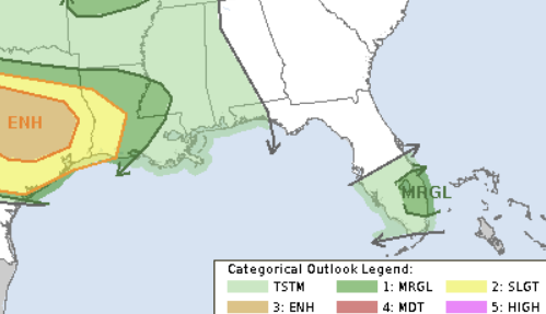
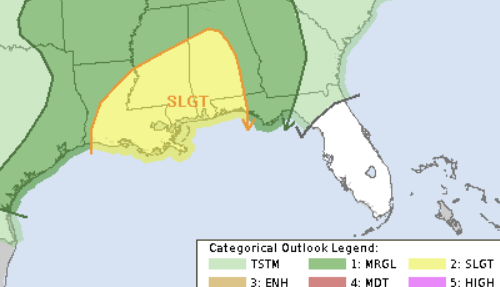
It should start out dry today, but expect showers and thunderstorms by later tonight. Some storms may be strong to severe. The Storm Prediction Center has parts of the area under a Slight Risk for severe weather. That is a “2” on the 1-to-5 scale where a “5” is the highest risk for the most significant severe weather.
With very moist air (PWAT values of 2.0 inches) and a strengthening low-level jet, heavy rainfall and flash flooding are likely along the front. High-resolution weather models, which have recently struggled with the timing of the rain but are doing a reasonable job with placement, have shown a batch of heavy rain through tonight, more tomorrow during the day and then again tomorrow night.
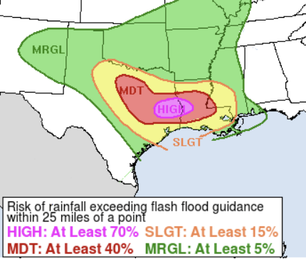
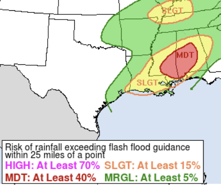
One thing to note that the flooding risk graphics above from the Weather Prediction Center use a slightly different scale than the SPC graphics I usually post. The WPC graphics use a 1-to-4 scale. So a “Moderate” in our area is a “3” on the 1-to-4 scale where “4” is the highest risk for the most catastrophic flash flooding.
That means there is a reasonable chance that we see some potentially life-threatening flooding in the area.
Getting nerdy for a moment, for you folks that enjoy reading about the parameters…. Tomorrow, as the weak cold front moves through, moist air (dewpoints in the lower 70s), instability (CAPE values near 3000 J/kg), strong wind shear (50-60 kt), and steep lapse rates (6-7 C/km) will support organized storms. On top of that, moisture levels (PW values between 1.6-2.0 inches) are high, and water vapor transport (IVT vectors) is exceptionally strong. This could lead to a combination of severe storms on the leading edge of things with training storms, causing flash flooding, behind it. Rainfall totals are now expected to be 1 to 4 inches, with most of the rain along and south of I-20.
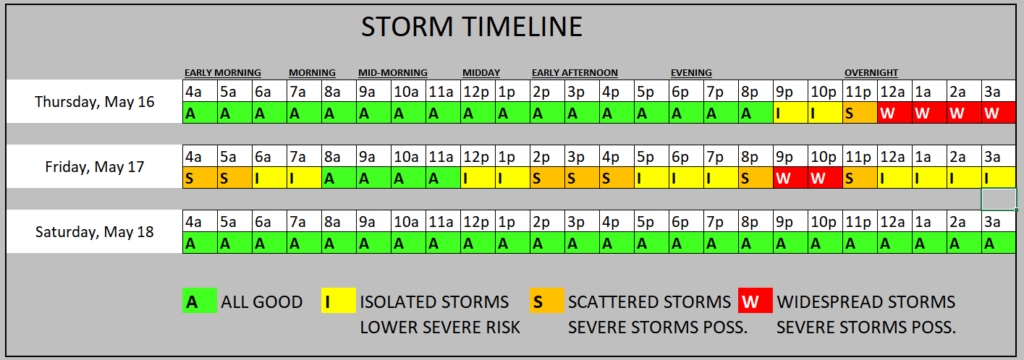
A couple of notes here:
– Storms don’t look as robust as the other day. Based on the available data, I don’t think we will see 90mph straight-line wind
– The tornado threat will be low, but not as low as it usually is this time of year. So a few tornadoes are possible
– A Severe Thunderstorm Watch or Tornado Watch will likely be posted tonight and then again tomorrow
– Flooding remains the biggest concern tonight and tomorrow. Yes, tornadoes and wind and lightning are a concern, but flooding is the biggest concern.
The best news I can offer is that after this things dry out. The bad news is that after this, things dry out — and I’m not really sure when we turn the spigot back on.
REGIONAL DAY TO DAY FORECAST
Today: Sunny. Highs around 90. Light and variable winds, becoming south around 5 mph this afternoon.
Tonight: Mostly cloudy. A slight chance of showers in the evening, then showers likely with a chance of thunderstorms after midnight. Lows in the upper 60s. Southeast winds around 5 mph. Chance of rain 60 percent.
Friday: Showers likely. A chance of thunderstorms in the morning, then thunderstorms likely in the afternoon. Highs in the mid 80s. South winds 10 to 15 mph with gusts up to 25 mph. Chance of rain 70 percent.
Friday Night: A chance of thunderstorms. A chance of showers in the evening, then showers likely after midnight. Lows in the upper 60s. South winds 5 to 10 mph. Chance of rain 70 percent.
Saturday: Showers likely. A chance of thunderstorms in the morning, then thunderstorms likely in the afternoon. Highs in the mid 80s. Southwest winds 5 to 10 mph. Chance of rain 70 percent.
Saturday Night: Partly cloudy in the evening, then clearing. Lows in the mid 60s.
Sunday: Sunny. Highs around 90.
Sunday Night: Mostly clear. Lows in the mid 60s.
Monday: Sunny. Highs in the lower 90s.
Monday Night: Mostly clear. Lows in the upper 60s.
Tuesday: Sunny. Highs in the lower 90s.
Tuesday Night: Mostly clear in the evening, then becoming partly cloudy. Lows in the upper 60s.
Wednesday: Mostly sunny. Highs in the lower 90s.


Thank you so much Nick for your professional expertise!