We’ve got a few showers out there this morning and perhaps a few rumbles of thunder. But the real risk for storms will arrive later today in the afternoon and evening.
While severe weather is unlikely, some storms could become strong, especially in the western parts of the area. We could see heavy rain, gusty winds, and possibly some hail. Highs today will be in the mid to upper 80s, with lows tonight in the mid to upper 60s. There’s also a potential for flash flooding overnight into Saturday as the storms continue.
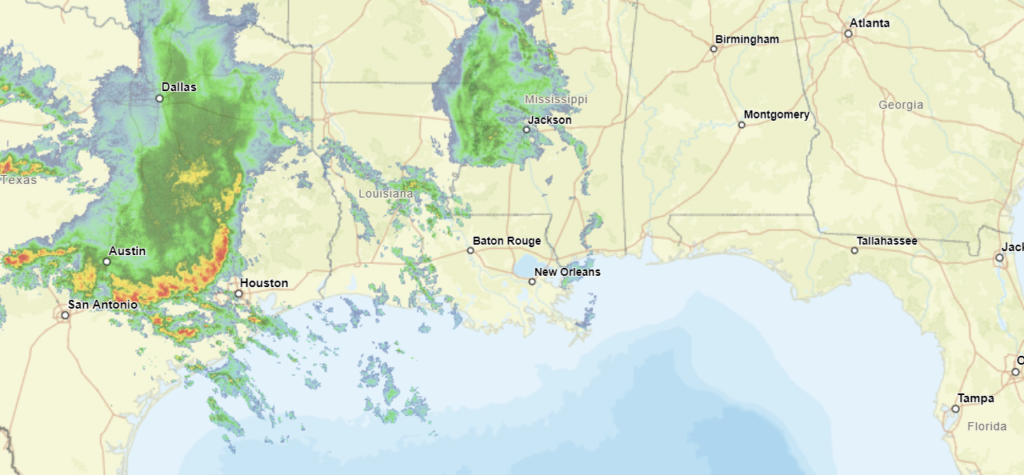
The threat for severe weather and flash flooding will persist through most of the upcoming week. A cold front will stall in the northwest part of our area, leading to ongoing storm activity. Early Saturday morning, a line of storms is expected to develop in southeast Arkansas, northeast Louisiana, and parts of western Mississippi. These storms will move southeast across central Mississippi by late morning and continue southward into the afternoon.
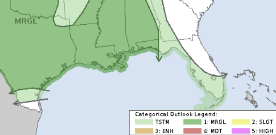
The main risks from these storms will be damaging winds and hail, with a slight chance of a brief tornado. A Marginal Risk for severe weather is in place for the area. That is a “1” on the 1-to-5 scale where a “5” is the highest risk for the most significant severe weather. Some storms could produce heavy downpours, with rainfall amounts between 2-4 inches possible, increasing the risk of flash flooding.
Storm chances will continue through Wednesday, with the potential for heavy rain, strong winds, and hail. Another cold front is expected to approach by Thursday, bringing more rain and the possibility of strong to severe storms.
REGIONAL DAY TO DAY FORECAST
Today: Mostly sunny. Highs around 90. Southeast winds 10 to 15 mph.
Tonight: Partly cloudy in the evening, then mostly cloudy with a chance of showers and thunderstorms after midnight. Lows in the lower 70s. Southeast winds 5 to 10 mph. Chance of rain 40 percent.
Saturday: Showers and thunderstorms. Highs in the mid 80s. South winds 5 to 10 mph. Chance of rain 90 percent.
Saturday Night: Mostly cloudy with a chance of thunderstorms. A chance of showers. Lows in the upper 60s. South winds 5 to 10 mph. Chance of rain 50 percent.
Sunday: Partly sunny. A chance of showers and thunderstorms in the morning, then showers and thunderstorms likely in the afternoon. Highs in the mid 80s. South winds 5 to 10 mph. Chance of rain 60 percent.
Sunday Night: Partly cloudy. A slight chance of showers and thunderstorms in the evening. Lows in the upper 60s. Chance of rain 20 percent.
Monday: Mostly sunny. A slight chance of showers and thunderstorms in the morning, then a chance of showers and thunderstorms in the afternoon. Highs in the upper 80s. Chance of rain 30 percent.
Monday Night: Partly cloudy. Lows around 70.
Tuesday: Sunny with a slight chance of showers and thunderstorms. Highs around 90. Chance of rain 20 percent.
Tuesday Night: Mostly clear. Lows in the lower 70s.
Wednesday: Mostly sunny. A slight chance of showers and thunderstorms in the afternoon. Highs in the lower 90s. Chance of rain 20 percent.
Wednesday Night: Partly cloudy. Lows in the lower 70s.
Thursday: Mostly sunny. A slight chance of showers and thunderstorms in the morning, then a chance of showers and thunderstorms in the afternoon. Highs in the lower 90s. Chance of rain 30 percent.


