Happy Monday! I hope that June has gotten off to a great start for you. We’ve got weather to talk about and there are two main topics I will be focusing on today. First, severe weather will be possible across portions of the Central United States tomorrow. Second, potentially dangerous heat is likely for the Southwest United States later this week.
Tuesday’s Severe Weather
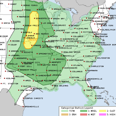
Yet another day of severe weather is possible for tomorrow. A “Slight Risk” (a “2” on the 1-to-5 scale where “5” is the highest risk for the most significant severe weather) has been issued by the Storm Prediction Center stretching from Kansas to Minnesota. Stronger storms will be centered near the Mid-Missouri Valley, where temperatures and wind shear will be more favorable. The main hazards include large hail initially followed by damaging winds as storms transition to a more linear pattern. A tornado or two cannot be ruled out either.
Timing for storms looks to be from late afternoon to evening on Tuesday. This will NOT be a widespread event and models still aren’t in good agreement, so rainfall totals could vary from nothing to over an inch across Kansas, Missouri, and Iowa. Pay attention to tomorrow’s forecast from the SPC when there should be more agreement on coverage and rainfall totals.
Southern Heat This Week
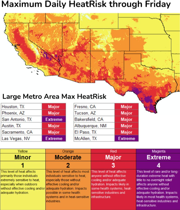
// Courtesy: National Weather Service
Who’s ready for the heat? An upper ridge is forecasted to develop across the Southwest United States early to mid-week. Heat indices have already surpassed the century mark in southern Texas today and will continue to so over the next couple of days. This dangerous heat will expand west across California and the Desert Southwest on Tuesday.
High temperatures will gradually climb into the 100s by Wednesday and Thursday with many records potentially being tied or broken. Cities such as Las Vegas, NV and Phoenix, AZ will likely top 110F for the first time this year by the latter half of the week. An Excessive Heat Warning is in effect for the Central Valley region of California while an Excessive Heat Watch is in effect for parts of the Desert Southwest.
Extended Outlook
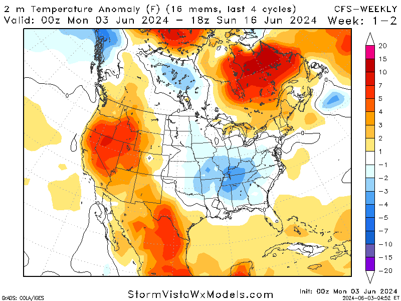
// Courtesy: Storm Vista
Unfortunately, above-average temperatures will likely continue for at least the next 10 days across the western United States. Upper-level ridging is forecasted to dominate the west which will lower the chances for seeing precipitation across this region. Areas such as southern New Mexico and southern Texas are already dealing with drought issues, so this could be a problem for them over the coming weeks.
From the Midwest to the Northeast, troughing will likely take place and help keep temperatures near or even below average. With northwesterly flow aloft, this may set the stage for multiple chances of showers and thunderstorms over the next 10 days as moisture will ride over the western ridge.
Conclusions
One last round of severe weather tomorrow from Kansas to Minnesota before a much-needed break is likely for at least the next couple of days.
Summer is officially here (for some of us at least) as the southern United States is forecasted to see multiple days of heat this week. If you live in these areas, limit your time outside and drink plenty of water.


