Well, there’s another chance of severe weather on Wednesday for the Ohio Valley. Luckily, this should be on the lower end and will not be a widespread event. We are also tracking rain chances for the Mid-Atlantic and Northeast on Wednesday and Thursday. Finally, record-breaking heat will continue to build in across the western United States as this is the first true heat wave of the year for places like the Desert Southwest.
Showers & Thunderstorms Possible On Wednesday for Ohio Valley
A mid-latitude cyclone is forecasted to move toward central and southern parts of Saskatchewan and Manitoba by early Wednesday. A cold front will extend southward through central Illinois and southern Missouri. As the low-pressure system moves further east throughout the day, warm, moist air will fuel thunderstorms along and ahead of the front.
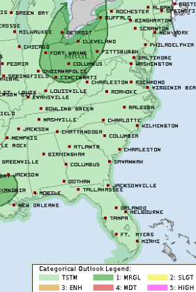
As of now, a “Marginal Risk” (a “1” on the 1-to-5 scale where “5” is the highest risk for the most significant severe weather) has been issued by the Storm Prediction Center stretching from Indiana and Michigan to western Pennsylvania and western New York.
There is still some uncertainty with some of the models. If cloud cover diminishes earlier Wednesday morning and afternoon, places like Indiana, southern Lower Michigan, and Ohio have the potential to see strong thunderstorms. The main hazards with these storms will be wind and hail, but a tornado or two cannot be ruled out, especially in Ohio.
East Coast Rain Chances
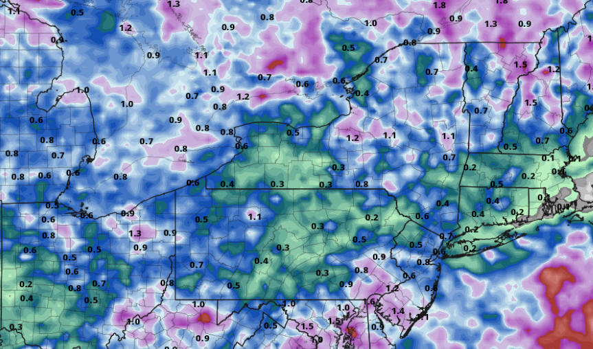
The same mid-latitude cyclone we talked about for Wednesday will be over portions of northwestern Ontario Thursday morning, before moving into the Upper Great Lakes later in the day. A cold front is expected to drag southward over western New York and eastern Pennsylvania. A few damaging wind gusts are possible throughout the day, however, the main focus will be rain. Most locations across the Northeast will likely see rainfall totals from 0.5″-1″, but some locations may exceed these totals.
Dangerous Heat Out West
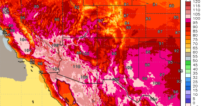
A strengthening upper ridge in the West will support a heat wave across much of the western United States over the next several days. Low-elevation regions of California’s Central Valley and the Desert Southwest will continue to feature high temperatures over 100 degrees. Locations may see high temperatures 20-30 degrees above their typical average for early June, leading to record-high temperatures.
Excessive Heat Warnings and Watches extend from the Central Valley down through southern California’s deserts, southern Nevada and southern/western Arizona. Heat indices could exceed 115F in some spots, so limit your time outdoors and drink plenty of water. The heat will peak over California’s Central Valley on Wednesday before expanding into the Desert Southwest later this week.


