Looking at the Big Picture of the tropics, we have a pretty active, but inconsequential setup for the next 24 hours. And truly the next three days.


The general flow in the atmosphere across the Gulf and east coast is from west to east with a reasonably trough in place across the Mid-Atlantic This would steer any tropical riff-raff out to sea before ever bothering the US. On top of that we have a developing trough that stretches from the yucatan across Cuba and out into the open Atlantic, too. This is riding around a weak area of high pressure that stretches from Africa to the Caribbean.
FORECAST BREAKDOWN
As we head through the next few days, we have the Central American Gyre to monitor as well as a wve near the Antilles. Neither will have a chance to do anything that would remotely impacts the area through late week.

I say, Central American Gyre, but it is worth noting that it is a bit of a tropical wave that is interacting with a weak gyre. And the current circulation max is on the other side of Central America

As we head through the next few days, model guidance – for both the GFS and Euro – suggest that a trough axis will develop from the Yucatan across the Florida Straights and out into the Atlantic. This will be where the focal point for showers and storms to develop will be. In the image below, the trough axis is the dashed black line with the orange(ish) lines representing the general “flow” in the atmosphere.
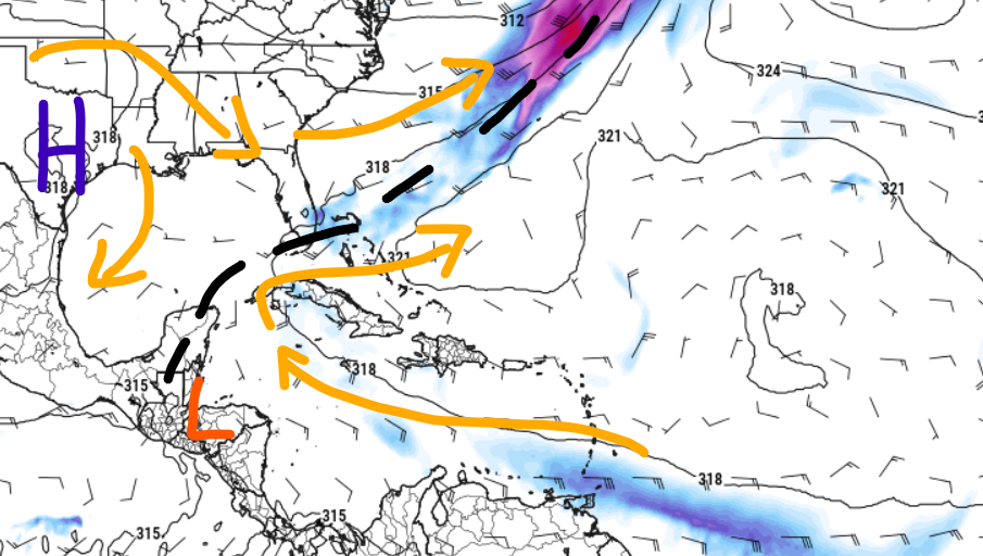
With a weaker ridge near Texas and a reasonable westerly flow – with an embedded wave -across the Caribbean, this should help to solidify an area of low pressure near Central America by midweek.
We could then see a bit of an extra shove by late week as the wave near the Lesser Antilles drifts toward the Yucatan. This could do one of a few things. It could (1) dislodge the trough axis to the north and into the Gulf, (2) disrupt the area of circulation near the Yucatan and break down the trough axis, (3) pass through and have very little impact.
Some model guidance wants to break off a piece of this things and move it NE and across Florida and out to sea. Other model guidance wants to move it into the central Gulf. And other model guidances shoves all of it into Mexico, across the bay of Campeche.
So, it is still TDB.
BOTTOM LINE
The next few days we will see a fair bit of activity bubble up in the Northwest Caribbean. But any impact to the local area is still quite a few days out. And we’re not certain what will – or won’t – happen later this week, at this point.

But the next few days look fine.


One thought on “Things getting more active this week in Caribbean: Tropical Weather Discussion – 6/9/24”
Comments are closed.