We’ve got things to talk about this time around, so let’s jump straight into it! First, there is a large area of showers and thunderstorms over the Florida peninsula which will continue to dump heavy rain over the next couple of days. Furthermore, we have a new area to watch highlighted by the National Hurricane Center across the southwestern Gulf of Mexico.

An elongated area of low pressure over the Florida peninsula continues to produce a large area of disorganized showers and thunderstorms. Although upper-level winds are expected to be only marginally conducive, some slow development is possible while the system moves northeastward offshore of the U.S. Southeast coast tonight through late week. Regardless of development, heavy rainfall is forecast to continue across portions of the Florida peninsula during the next few days. For more information, see products issued by the Weather Prediction Center and local National Weather Service Forecast Offices.
* Formation chance through 48 hours…low…10 percent.
* Formation chance through 7 days…low…20 percent.
A broad area of low pressure could form over the weekend across the southwestern Gulf of Mexico. Environmental conditions appear conducive for some slow development early next week while the system moves slowly westward or west-northwestward.
* Formation chance through 48 hours…low…near 0 percent.
* Formation chance through 7 days…low…30 percent.
Invest 90L
It has been quite the rainy week so far across the Florida peninsula as locations such as Sarasota have already picked up over 10 inches of rain! This will certainly help the current drought in central and southern Florida, but that much rain in a short period of time resulted in flooding for some areas.
Invest 90L only has a 20% of formation over the next week as strong upper-level winds and cooler sea surface temperatures across the southeast coastline will keep this system very messy and disorganized.
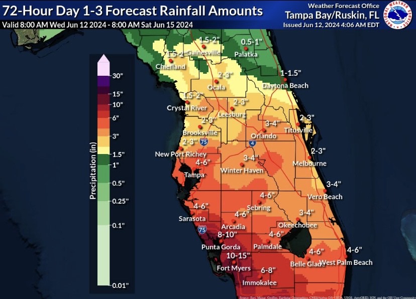
Regardless of development, heavy rain will continue to be the main headliner as gulf moisture advects northward. Southwest Florida is still forecasted to see the heaviest rain as locations between Venice and Bonita Springs are likely to pick up over 6 inches of additional rainfall. If you live in an area prone to flooding, avoid driving and follow local radio or tv updates.
Area to Watch
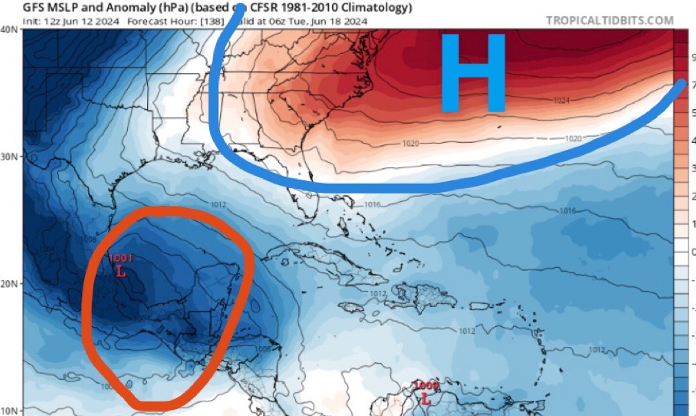
As Invest 90L moves northeast into the open Atlantic, high pressure will begin to build in at the surface across the eastern United States as we head into early next week. While this is happening, a broad area of showers and thunderstorms is forecasted to move into the southwestern Gulf of Mexico.
The good news is that we have plenty of time to watch this and development will be slow. The strength and location of the surface high will end up determining who may see rain from this.


One thought on “6/12/24 – Tropical Outlook: Invest 90L and a new area to watch”
Comments are closed.