Happy Friday, everyone! Now that hurricane season has begun, it is important to properly understand how the “cone of uncertainty” works by the National Hurricane Center. I was reading through this article that I thought did an excellent job of explaining how difficult it can be to receive the right information during a tropical storm or hurricane.
Today, there are so many ways to get alerts on the weather, so it is important for you to know who to trust and how to take action.
Summary
The National Hurricane Center (NHC) is a group in charge of tracking and predicting tropical weather to keep us safe and minimize damage. With a lot of things in meteorology, there is high uncertainty when it comes to forecasting tropical systems. Even though these storms are more slow-moving, tropical storms and hurricanes impact millions of people, so preparation is key and takes place days before landfall.
Most of the time, people make decisions based on the forecast cone put out by the NHC. The cone of uncertainty was introduced in 2002 and has changed the way that people plan. We’ve seen advancements in radar, aircraft, satellite, and more meteorological tools to help forecasters understand the current conditions as well as future impacts.
The intention of the NHC cone is to “provide information on any given tropical cyclone so those potentially impacted can make timely and responsible decisions” (652-653). This is great… until the general public doesn’t understand what the potential impacts are for their area. Many people tend to follow the black track line on the cone to determine what they should do.
Unfortunately, impacts from tropical systems can be felt well outside the cone such as storm surge, flooding, wind damage, and more. Or worse, a last-minute shift in the track of the cone can put your area in the heart of the storm.
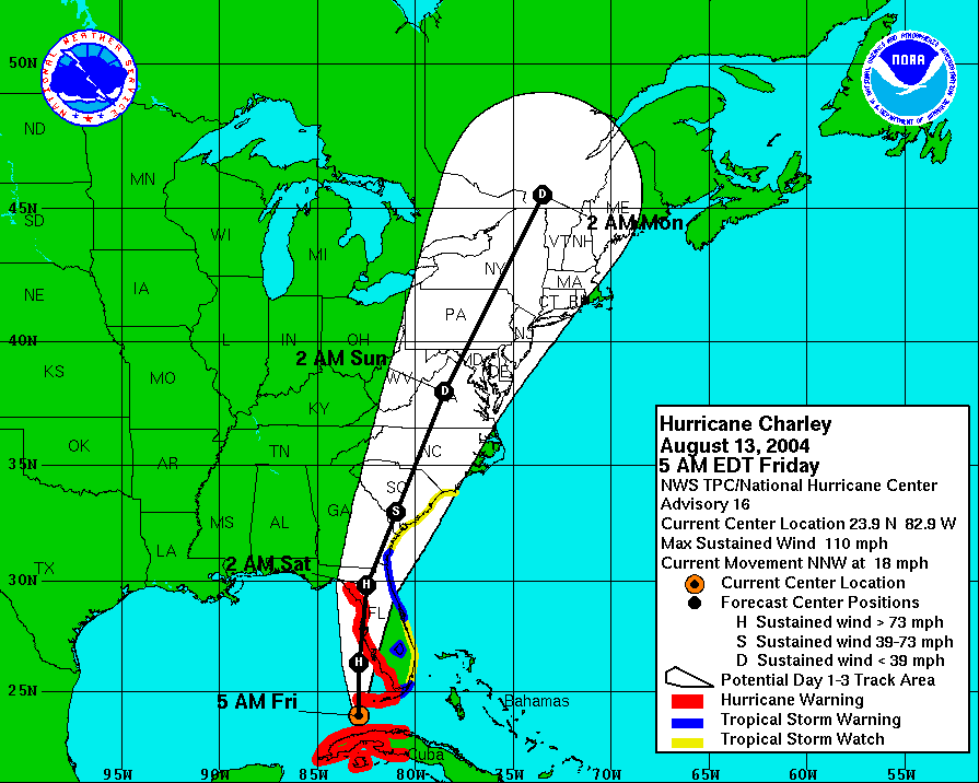
Hurricane Charley is a great example on why you shouldn’t always pay attention to the track line. 24 hours before landfall, Charley was projected to make landfall around Tampa Bay, FL. Instead, there was a sudden shift to the south and the storm made landfall near Fort Myers, FL. People weren’t as prepared there and Charley ended up doing massive damage to the area.
How do we fix this issue? It starts with communication. Twitter, Tik Tok, television, websites, etc… there are so many ways to hear about the weather. The key is to know who to trust and the two main groups that jump to mind are either a degreed meteorologist from media outlets or some sort of government agency like the NHC or the National Weather Service.
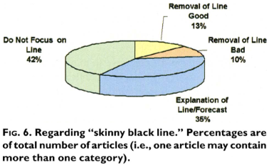
Next, we need to focus on potential impacts for areas rather than spending excessive time on where landfall could be. Above is a figure that shows how confusing and distracting the forecast track line can be. Instead, we should inform people on how high the storm surge can be, how much rain could fall, how you should protect your home from a hurricane, how to evacuate correctly, and other messages like that.
Speaking of confusion, sometimes individual TV stations “will alter the color and style of the NHC graphic by making fundamental changes and possibly removing the hurricane forecast track line” (655). I don’t mind stations breaking things down to make it easier for the general public to understand, but altering the cone and colors could lead to many people questioning the forecast.
3 Things for Future Study:
- Preparation – What are some of the main reasons why people aren’t prepared for hurricanes? Is it due to the lack of proper communication, the public not taking these storms seriously, or something else? It takes days to prepare for something like a hurricane.
- Educate – How can we properly deliver key messages to people? How do we eliminate non-trustworthy sources? Should we find more ways to demonstrate how people should plan for hurricanes? Take the time to educate yourself, so you feel more comfortbale the next time a hurricane impacts you.
- Research – Are probability forecasts the way to go? How can we improve predicting tropical storms and hurricanes? Is hurricane season going to be worse in 25 years? Forecasting is only going to get easier from here, so hopefully we can continue to find ways to communicate things more clearly.
Modern Meteorology:
This article addresses a very important point regarding how we should communicate tropical weather to the public. The problem doesn’t typically involve the forecast, models, or data. Usually, it relates to how people weren’t prepared because they didn’t understand the potential impacts or severity of the storm. We need to do a better job at explaining things whether it’s broadcast meteorology or operational. Hurricanes are such powerful storms and a forecast cone doesn’t show the full impacts it can have. Hopefully, we can continue to improve on this, so you can be weather-ready! Thank you for reading this!
Works Cited:
Broad, K., A. Leiserowitz, J. Weinkle, and M. Steketee, 2007: Misinterpretations of the “Cone of Uncertainty” in Florida during the 2004 Hurricane Season. Bull. Amer. Meteor. Soc., 88, 651–668, https://doi.org/10.1175/BAMS-88-5-651.


