it’ll be another hot one, today. That isn’t a big surprise, I’m sure. Highs will be back around 95F. The NWS has issued an Excessive Heat Warning for some and a Heat Advisory for others. But it is a bit of an exercise in semantics. It will be hot. everywhere.


There is a slight chance of showers and storms along the HWY 98 corridor and closer to the coast, everyone else may just bake.
High pressure will continue to build eastward through the region during the week. The slightly drier air at the start of the week will be replaced by more moisture, increasing chances for showers and thunderstorms each afternoon from mid to late week. These rain chances will continue through the weekend as a frontal boundary is expected to move into the region on Saturday and Sunday.
Despite this, the heat will remain a concern throughout much of the forecast area, with temperatures consistently rising into the mid to upper 90s each day. This, combined with increasing moisture, will result in afternoon heat index values exceeding 100°F. From Wednesday through Friday, heat index values will be in the 105-110F range, likely necessitating a Heat Advisory for parts of the area.
Looking at the big picture by later this week, the GFS computer weather model suggests that the ridge slides east and it opens the door for a weak front to try to dive into the area.
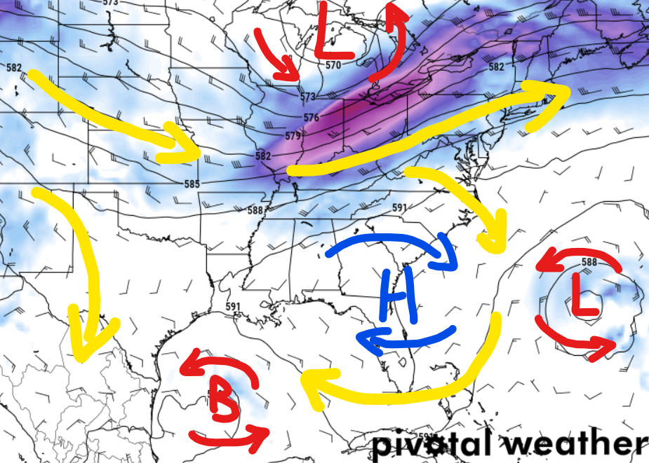
The map above highlights that even if we get that front, the overall pattern is still a general southerly and southeasterly flow (yellow arrows).
All the while, we are monitoring Beryl in the Tropics. The once-Category 5 Hurricane, will eventually make it to the Gulf. And depending on how the atmospheric puzzle pieces are aligned, it may try to curly-cue to the north once it gets past the Yucatan.

I still think that the farthest east it could possibly get if it turns more northward is the Louisiana coastline, but it still bears monitoring.
REGIONAL DAY TO DAY FORECAST
Today: Sunny. A slight chance of showers and thunderstorms this afternoon. Highs in the upper 90s. North winds 5 to 10 mph. Chance of rain 20 percent. Heat index values up to 112.
Tonight: Mostly clear. A slight chance of showers and thunderstorms in the evening. Humid with lows in the mid 70s. North winds around 5 mph in the evening, becoming light and variable. Chance of rain 20 percent. Heat index values up to 110 early in the evening.
Tuesday: Mostly sunny. A slight chance of showers in the morning, then a chance of showers and thunderstorms in the afternoon. Humid with highs in the mid 90s. Northeast winds around 5 mph, becoming southeast in the afternoon. Chance of rain 50 percent. Heat index values up to 111.
Tuesday Night: Partly cloudy with a slight chance of showers and thunderstorms. Humid with lows in the mid 70s. Southeast winds around 5 mph. Chance of rain 20 percent. Heat index values up to 106 early in the evening.
Wednesday: Mostly sunny. A chance of showers and thunderstorms in the morning, then showers and thunderstorms likely in the afternoon. Humid with highs in the lower 90s. Southeast winds 5 to 10 mph. Chance of rain 60 percent. Heat index values up to 107.
Wednesday Night: Partly cloudy in the evening, then becoming mostly clear. Lows in the mid 70s. Heat index values up to 105 early in the evening.
Independence Day: Mostly sunny. A slight chance of showers and thunderstorms in the morning, then a chance of showers and thunderstorms in the afternoon. Highs in the mid 90s. Chance of rain 40 percent. Heat index values up to 110.
Thursday Night: Partly cloudy in the evening, then becoming mostly clear. Lows in the mid 70s. Heat index values up to 105 early in the evening.
Friday: Sunny. A chance of showers and thunderstorms in the afternoon. Highs in the upper 90s. Chance of rain 30 percent. Heat index values up to 110.
Friday Night: Partly cloudy in the evening, then becoming mostly clear. Lows in the mid 70s. Heat index values up to 105 early in the evening.
Saturday: Mostly sunny. A slight chance of showers and thunderstorms in the morning, then a chance of showers and thunderstorms in the afternoon. Highs in the mid 90s. Chance of rain 40 percent. Heat index values up to 110.
Saturday Night: Partly cloudy. A slight chance of showers and thunderstorms in the evening. Lows in the mid 70s. Chance of rain 20 percent. Heat index values up to 105 early in the evening.
Sunday: Mostly sunny. A slight chance of showers and thunderstorms in the morning, then a chance of showers and thunderstorms in the afternoon. Highs in the mid 90s. Chance of rain 40 percent. Heat index values up to 110.


