Technically speaking, the forecast read: “Expect significant heat stress and convective rainfall today.”
But that sounds overly dramatic. So, intead, I’ll say, “Get ready for it to be hot and humid weather with a chance for storms.
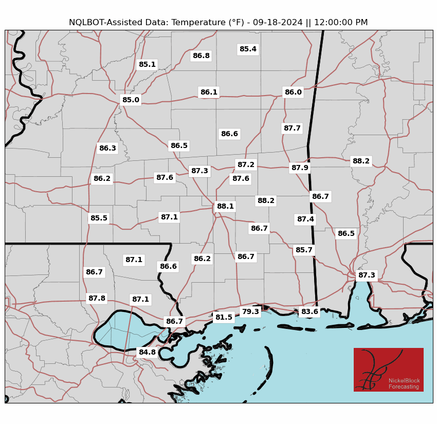
This morning, temperatures barely dropped below 80F in most spots, making it easy to reach heat advisory criteria. A heat advisory is in effect for the entire area. A cold front will try to move through today, bringing some minor relief. The weekend will be “less-hot” with highs in the low to mid 90s, with heat indices of 100-105F. Overnight lows will be slightly cooler, ranging from 74-77F.
We continue to watch Hurricane Beryl, too. tT made the second landfall this morning, moving ashore across the Yucatan peninsula.

As of this writing, it is forecast to move back out into the open waters of the Gulf and wrap around an area of high pressure, making landfall somewhere near the Texas/Mexico border. Though, there is some indications that it will slow down as it moves toward shore, and that may impact where landfall occurs. The cone depicts a “reasonable worst case scenario” with an outside shot for Beryl to skirt the coastline of Texas, remaining in the Gulf for longer.
The path will dictate the who sees the impacts. And the impacts will be rain, wind and storm surge.
Back here, next week, it will start off warm, but then become a bit more “uncertain” given where the remnants of Beryl may end up. If Beryl dissipates quicker, excessive heat conditions could return. If it doesn’t we could be talking about some pretty heavy rainfall, with a slight risk of isolated flash flooding midweek due to potential heavy rains.
REGIONAL DAY TO DAY FORECAST
Today: Patchy fog this morning. Partly sunny with a chance of showers and thunderstorms this morning, then mostly cloudy with showers and thunderstorms likely this afternoon. Highs in the lower 90s. West winds around 5 mph. Chance of rain 40 percent. Heat index values up to 109.
Tonight: Mostly cloudy. A chance of showers and thunderstorms, mainly in the evening. Humid with lows in the mid 70s. Southwest winds around 5 mph in the evening, becoming light and variable. Chance of rain 20 percent.
Saturday: Partly sunny. A chance of showers and thunderstorms in the morning, then showers and thunderstorms in the afternoon. Humid with highs in the mid 90s. Northwest winds around 5 mph. Chance of rain 40 percent. Heat index values up to 112.
Saturday Night: Mostly cloudy. A chance of showers and thunderstorms in the evening. Humid with lows in the mid 70s. Light and variable winds. Chance of rain 30 percent. Heat index values up to 107 early in the evening.
Sunday: Partly sunny. A chance of showers and thunderstorms in the morning, then showers and thunderstorms likely in the afternoon. Humid with highs in the lower 90s. North winds around 5 mph, becoming southwest in the afternoon. Chance of rain 40 percent. Heat index values up to 107.
Sunday Night: Mostly cloudy. A chance of showers and thunderstorms in the evening. Lows in the mid 70s. Chance of rain 20 percent.
Monday: Partly sunny. A chance of showers and thunderstorms in the morning, then showers and thunderstorms likely in the afternoon. Highs in the lower 90s. Chance of rain 40 percent. Heat index values up to 105.
Monday Night: Mostly cloudy with a chance of showers and thunderstorms in the evening, then partly cloudy after midnight. Lows in the mid 70s. Chance of rain 30 percent.
Tuesday: Mostly sunny. A chance of showers and thunderstorms in the morning, then showers and thunderstorms likely in the afternoon. Highs in the lower 90s. Chance of rain 40 percent. Heat index values up to 105.
Tuesday Night: Mostly cloudy with a slight chance of showers and thunderstorms in the evening, then partly cloudy after midnight. Lows in the mid 70s. Chance of rain 20 percent.
Wednesday: Mostly sunny. A slight chance of showers and thunderstorms in the morning, then a chance of showers and thunderstorms in the afternoon. Highs in the mid 90s. Chance of rain 40 percent. Heat index values up to 105.
Wednesday Night: Partly cloudy. A slight chance of showers and thunderstorms in the evening. Lows in the mid 70s. Chance of rain 20 percent.
Thursday: Mostly sunny. A slight chance of showers and thunderstorms in the morning, then a chance of showers and thunderstorms in the afternoon. Highs in the mid 90s. Chance of rain 30 percent. Heat index values up to 105.


