Hello there; thanks for taking the time to read this research. This is my second piece of research for the summer, and I have decided to switch things up from my last research paper. This time, I have decided to study upslope snowstorms, precisely two different types of events that occurred in the United States.
Before going into these events that I looked at, I want to give some background on upslope snowstorms. I will summarize the two research articles I found, which discuss two different types of upslope events.
Basics
One of the papers discusses a snowstorm that impacted Colorado in October 1997 and how mesoscale models are essential in forecasting specific snowfall amounts in mountainous regions. The other paper examines the dynamics of synoptic scale upslope snowfall events in the Appalachian Mountains in the Southeastern U.S. I hope you can learn something new from this research.
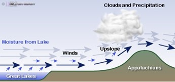
Before discussing the research articles I found, I want to go over the basics of an upslope snowstorm event. An upslope snowstorm is when cold, moist air is forced up a mountain slope. The air cools rapidly as it ascends, allowing heavy snow to fall along these mountain ranges. Here in the United States, these events are most commonly seen along the Front Range of the Rocky Mountains and the western-facing Appalachian Mountains. These snowstorms typically occur from mid-fall to late spring, when cold air and winter conditions exist in the northern hemisphere. These snow events can produce a high total snowfall; for example, Silver Lake, Colorado, recorded 76 inches of snow in 24 hours.
This was the most snowfall recorded in a 24-hour period in the Continental U.S.
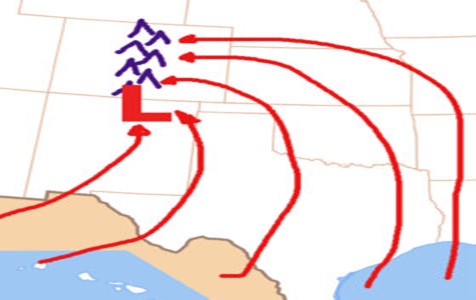
The setup of upslope snowstorms generally starts when the center of a low-pressure system sets itself near a major mountain range, allowing moisture to be drawn in from a large body of water. In the case of the Appalachian Mountains, winds typically blow from the northwest, allowing cold, moist air from the Great Lakes to impact the mountains. Out in the Rockies, moisture is drawn in from the Gulf of Mexico and collides with cold air from Canada. Cold enough temperatures are also required to produce snowfall, with rainfall occurring if temperatures are not cool enough.
These snowstorms can result in heavy snow accumulation on mountain ranges, disrupt travel plans, increase the risk of avalanches, and enhance the seasonal snowpack. The next part of this writing will summarize the two papers that I read for this writing.
The Research
The first paper I looked at is titled “A Rocky Mountain Storm. Part I: The Blizzard—Kinematic Evolution and the Potential for High-Resolution Numerical Forecasting of Snowfall” by Gregory S. Poulos, Douglas A. Wesley, John S. Snook, and Michael P. Meyers. This research aimed to look at mesoscale high-resolution weather forecasting models, how accurate they were, and what could be done in the future. The weather event examined for this research was an upslope snowstorm in the Front Range of Colorado in October 1997. The snowstorm storm was caused by a stationary cutoff low, allowing moisture to flow into the Front Range. A cold front had moved through the region before the low’s arrival, providing the necessary cold air. This particular storm affected areas from Wyoming to Southern New Mexico, caused numerous travel impacts around the Denver Metropolitan Area, shut down the then-new Denver International Airport, and produced blizzard conditions throughout the mountains of Colorado.
The primary goal of this research was to utilize computer models to forecast localized or mesoscale snowfall amounts. The storm’s upslope nature and early timing (in terms of the cold season) resulted in radically different snowfall amounts over a small area. To understand the dynamics of the storm, the researchers used the Regional Atmospheric Modeling System (RAMS) to generate a simulation of the storm. The model used different grid spacings of 5 Km and 1.67 Km to predict the snowfall amounts and where they were distributed. When the grid spacings were used, it significantly improved how accurately the snowfall could be forecasted. The percentage error found was 41% at 5 Km and 9% at 1.67 Km grid spacing.
This study showed how the RAMS model could more accurately predict snowfall that is affected by local geography and topography, especially if the storm in question has upslope characteristics. Using this model would allow for a more reliable forecast for upslope snow events in the Front Range of the Rocky Mountains and the Denver Metro Area.
The second research paper I read is titled ” Synoptic-Scale Features Common to Heavy Snowstorms in the Southeast United States” by Thomas L. Mote, Douglas W. Gamble, S. Jeffrey Underwood, and Mace L. Bentley. This research aims to understand the atmospheric dynamics of heavy synoptic-scale snowstorms in the Southeastern United States. This paper focuses on finding the critical patterns of these snowstorms and how understanding these patterns can help improve forecasting accuracy. The particular snowstorms looked at are upslope snowstorms that affect the western-facing Appalation Mountains. Unlike the Rockies, these snowstorms are much larger in size, hence why this paper looks at synoptic scale events.
The study looked at 22 heavy snowstorms, but only 18 of them could be used due to a lack of data or unique characteristics that could cause inaccurate data. The City of Ashville, North Carolina, was used for this study since its weather station had hourly snowfall data. Each time a storm impacted the region, the 00z time was used based on the onset of snowfall.
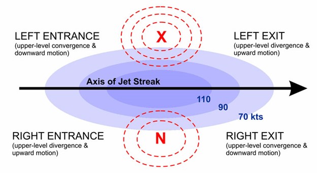
Typical synoptic data include sea level pressure, temperature, winds, humidity, and other data points. There were quite a few critical features found with these synoptic snowstorms. Warm air advection was found to be the primary mechanism for the upward motion of these storms. If you don’t know how warm air advection works, it involves warm air being forced above colder air, producing precipitation as the warm air rises. Another ingredient to upslope storms in the Appalachians is how the upper-level jet streaks affect snowfall. It was found that the right entrance, the upper-level part of the jet streak, contributed to upward motion. This allowed more moisture to flow upwards, causing more snowfall in the region.
Another ingredient that these storms possessed was moisture from both the Gulf of Mexico and the Atlantic Ocean. Synoptic-scale snowstorms need moisture, and both of these large bodies of water provide the necessary moisture for these storms. One thing that this research found was that anticyclones tended to deepen near the coast of the Carolinas.
Although this setup can lead to heavy snowfall in the Northeast, the studied region saw little effect from this setup. Some other effects observed from these snowfall events were diabatic processes and cyclogenetic lift; however, it was found that warm air advection and upper-level jet streaks were the primary contenders in upslope snowfall in the Appalachian Mountains of North Carolina. Because of these findings, meteorologists can provide a more accurate weather forecast for upslope snowfall in the Appalachian Mountains of North Carolina. While there were discoveries of synoptic scale features related to upslope snowfall, more research is needed, especially on how warm air advection is affected by local geography.
From what I found in this research, it was obvious that local geography has a significant effect on mesoscale snow events and synoptic-scale snow events. This area of research is critical since these upslope events can significantly impact society and produce high levels of snow in a short time. This area of research has led to new information regarding upslope snowfall; however, more research is needed to improve forecasting on both synoptic and mesoscale levels. I want to take a moment to thank the people who wrote both of the papers used in this research and give credit to those who created the graphs used in this paper.
References
Babb, D. (2019). Upper-level jet streaks. Upper-Level Jet Streaks | Learning Weather at Penn State Meteorology. https://learningweather.psu.edu/node/100
Moser, H. (2021, March 8). Anatomy of an upslope snowstorm. Colorado Wilderness Rides and Guides. https://coloradowildernessridesandguides.com/backcountry-skiing/anatomy-of-an-upslope-snowstorm/
Mote, T. L., Gamble, D. W., Underwood, S. J., & Bentley, M. L. (1997, March 1). Synoptic-scale features common to heavy snowstorms in the Southeast United States. AMETSOC. https://journals.ametsoc.org/view/journals/wefo/12/1/1520-0434_1997_012_0005_ssfcth_2_0_co_2.xml?tab_body=abstract-display
Poulos, G. S., Wesley, D. A., Snook, J. S., & Meyers, M. P. (2002, October 1). A Rocky Mountain Storm. part I: The blizzard-kinematic evolution and the potential for high-resolution numerical forecasting of snowfall. AMETSOC. https://journals.ametsoc.org/view/journals/wefo/17/5/1520-0434_2002_017_0955_armspi_2_0_co_2.xml
Robinson, D. (2007, November 15). Upslope snow in the Appalachians: The basics. Storm Highway by Dan Robinson. https://stormhighway.com/blog/nov1507a.php


