Our run of Experienced Temps near 110F should come to a brief end. How does 105F sound, instead? Almost Arctic!
Jokes aside, afternoon temperatures should be reasonable the next two days. I think we will have to earn it with rain – but hey, better than melting!


By early afternoon, we’ll see a storms develop. Those storms will become a bit more widespread across the area as the day moves on. With this moist air moving in, heat indices will rise, potentially reaching around 105 degrees in parts of central and southeast Mississippi. As a result, a Heat Advisory is in effect from 10 AM to 7 PM.
We may see the storms linger around through the overnight hours tonight. And if some of these storms end up as slow moving as we expect, you may see some isolated flash flooding in low-lying spots. I don’t think flooding will be widespread of catastrophic, but gullies and creeks may get pretty full. While we can’t rule out some strong storms, severe weather is not expected at this time.
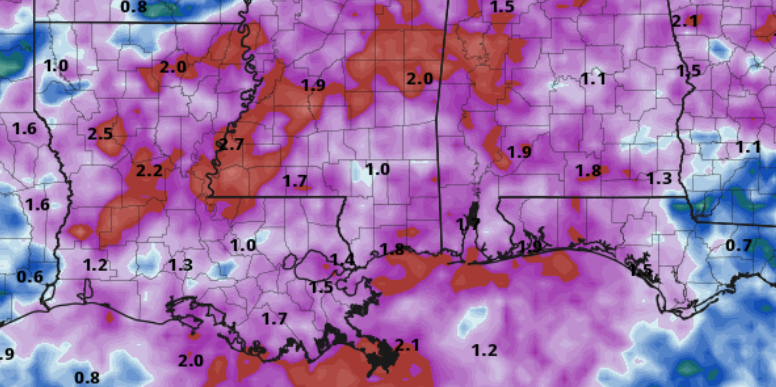
This pattern may hold for the next few days with rainfall amounts around 1-3 inches generally, and possibly even 4-6 inches in localized spots where some of the heavier storms develop. While that isn’t reflected on the map below, I think there is still the potential for some folks to get pretty drenched.
Looking toward the weekend, temperatures will be seasonably cool, with highs in the 80s on Friday and through the weekend for many spots – a few low 90s can’t be ruled out. Overnight lows will remain in the upper 60s to low 70s. Patchy fog is possible in areas that receive substantial rainfall.
As we move into early next week there is a chance we hold this semi-unsettled pattern for a few more days before we shake out of it and warm back up.
REGIONAL DAY TO DAY FORECAST
Today: Mostly sunny. A slight chance of showers and thunderstorms this morning, then showers and thunderstorms this afternoon. Highs in the lower 90s. Northwest winds around 5 mph, becoming southwest around 5 mph this afternoon. Chance of rain 80 percent. Heat index values up to 105.
Tonight: Mostly cloudy with showers and thunderstorms likely in the evening, then partly cloudy with a chance of showers and thunderstorms after midnight. Lows in the lower 70s. Southwest winds around 5 mph in the evening, becoming light and variable. Chance of rain 60 percent.
Friday: Showers and thunderstorms. Humid with highs in the upper 80s. South winds around 5 mph. Chance of rain 80 percent.
Friday Night: Showers and thunderstorms likely. Lows in the lower 70s. South winds around 5 mph in the evening, becoming light and variable. Chance of rain 40 percent.
Saturday: Showers and thunderstorms. Humid with highs in the upper 80s. South winds around 5 mph. Chance of rain 80 percent.
Saturday Night: Showers and thunderstorms likely, mainly in the evening. Lows in the lower 70s. Chance of rain 40 percent.
Sunday: Showers and thunderstorms. Highs in the upper 80s. Chance of rain near 70 percent. Heat index values up to 105.
Sunday Night: Mostly cloudy with a chance of showers and thunderstorms. Lows in the lower 70s. Chance of rain 20 percent.
Monday: Partly sunny. A chance of showers and thunderstorms in the morning, then showers and thunderstorms in the afternoon. Highs in the upper 80s. Chance of rain 50 percent.
Monday Night: Mostly cloudy. A chance of showers and thunderstorms, mainly in the evening. Lows in the lower 70s. Chance of rain 20 percent.
Tuesday: Partly sunny. A chance of showers and thunderstorms in the morning, then showers and thunderstorms in the afternoon. Highs in the upper 80s. Chance of rain 40 percent. Heat index values up to 105.
Tuesday Night: Mostly cloudy with a chance of showers and thunderstorms. Lows in the lower 70s. Chance of rain 20 percent.
Wednesday: Showers and thunderstorms. Highs in the upper 80s. Chance of rain 40 percent.


Much appreciated forecast and your time and efforts for getting it to us. Thank you!